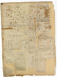
Page 140 of the City Engineer's Plat Book with six plats. Plat 1 shows lots and structures located on and near Queen Street, between King Street and Meeting Street. Plat 2 shows lots located on Rutledge Street. Plat 3 shows lots located between George Street and Burns Lane, near where they intersect with Meeting Street. One lot is labelled "Property of Charleston High School." Plat 4 shows lots and structures located between Lynch Street and the Ashley River, near Broad Street and Beaufain Street. Plat 5 shows lots and structures located on the corner of King Street and Society Street. Plat 6 shows the same area as Plat 5, but with some changes to the structures.
Page 101 of the City Engineer's Plat Book with two plats. Plat 1 shows lots located between Washington Street and Wharf Street, and between Calhoun Street and Laurens Street. Plat 2 shows lots located near the intersection of Rutledge Avenue and Line Street, with several buildings labelled.
Page 78 of the City Engineer's Plat Book with five plats. Plat 1 features land and lots located near the Ashley River, including geographic features such as marshland, high land, and bodies of water. Plat 1 also shows Boundary Street, Hutson Street, Doughty Street, Bee Street, Elliot Street, Cannon Street, President Street, and Thomas Street. Plat 2 shows a city block between Doughty Street and Bee Street, and between President Street and Thomas Street, with some marsh labelled. Plat 3 features land and lots located near the Ashley River, with shoals and streams labelled. Plat 3 also shows Boundary Street, Pinckney Street, Cannon Street, Hutson Street, Doughty Street, and Bee Street. Plat 4 shows lots located near the intersection of Calhoun Street and Lucas Street, and shows several structures and a stretch of a creek. Plat 5 shows lots features lots located between Lucas Street and Ashley Street, and Mill Street and Doughty Street. Plat 5also shows Palmetto Street, President Street, and a lot labelled "U. S. Arsenal Square."
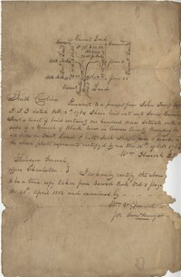
Plat of 42 acres in St. George’s Parish belonging to Nathaniel Bradwell. Very little detail included with the plat. Names associated with this plat include Nathaniel Bradwell, John B. Giradeau, E.G. Montagu, John Barker, and Peter Haskins.
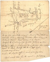
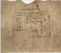
56 acre plot of land given to Radcliffe, the plot of land is bordering Cuckolds Creek, shows surrounding property owners, no land type detail or identification. Names associated with this plat are Thomas Radcliffe, Nathaniel Heyward, John Goddard and James Heyward. Notable geographic locations include Cuckolds Creek, Combahee River and St. Bartholomew's Parish.
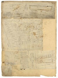
Page 24 of the City Engineer's Plat Book with three plats. Plat 1 shows lots located near King Street, Meeting Street, Wolf Street, March Lane, and Reid Street, including a portion of land labelled "Old fish pond low & broken land" and large label reading "Part of Hampstead." Plat 2 shows lots and features near the Charleston Harbor on the Cooper River, Boundary Street, Charlotte Street, Washington Street, and East Bay Street, and notes the "High Water Mark at Common Tides." Plat 3 shows lots located Meeting Street, Elizabeth Street, Ann Street, John Street, "Chapple Street," Alexander Street, and Washington Street, including a lot labelled "Tobacco Inspection."
General Cutherbert's land on Big Pipe Creek. Names associated with this plat are General Cuthbert, B.H. Roberts, Ball, Peters and David DeSapah [?]. Notable geographic locations include the Savannah River.
Page 183 of the City Engineer's Plat Book with five plats. Plat 1 shows lots located along Simons Street, between King Street and a stretch of marshland. Plat 2 shows lots on and near "Simmons" Street. It also shows lots near King Street and Romney Court. Plat 3 shows lots located near the intersection of King Street and Grove Street. Plat 4 shows lots and structures located near the intersection of Simons Street and King Street. Plat 5 shows lots along Simons Street, located between King Street and a stretch of marshland.
Copy of a plat of a tract of land containing 100 acres situated on the west side of branch of Black River in Craven County bounding on all sides on vacant land. Names associated with this plat are John Trough, James Bauman, Robert McDaniel, Gluscork [?], Howard, and Samuel Bunger. Geographic locations include Craven County [now in parts of Berkeley, Charleston, Georgetown, and Williamsburg counties], Black River, and Blues River.
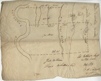
Plat contains 200 acres conveyed to Thomas McConnell of W town 1814. Granted to Duyal Mckechaw in 1735. Names associated with this plat are Thomas McConnell, Duyal Mckechaw, John Summerhoofs, Eliza Staufiur, and John White.
Page 76 of the City Engineer's Plat Book with three plats. Plat 1 shows land roughly between the Ashley River and Coming Street, and roughly between Elliot Street and Comings Creek. Plat 1 also shows multiple streams, marshes, and islands. It also includes Boundary Street, Doughty Street, Bee Street, Cannon Street, Smith Street, Pinckney Street, and Thomas Street. Plat 2 shows lots and some buildings located between Spring Street and a marsh, along an road labelled "Court." Plat 3 features lots located between Morris Street and Radcliffe Street, near their intersections with Pitt Street, "Commings Street," St. Philips Street, and King Street. Plat 3 also shows some marshland. Plat 4 features lots located between Smith Street and Coming Street, and between Radcliffe Street and Vanderhorst Street. Plat 4 also shows the intersection of Warren Street and Thomas Street.
Page 86 of the City Engineer's Plat Book with four plats. Plat 1 shows land starting west of Legare Street and ending east of America Street. Plat 1 also includes Line Street, Pinckney Street, King Street, Meeting Street, America Street, a public square, and several marshes. Plat 2 shows a stretch of land starting west of Legare Street and ending at Drake Street. Plat 2 also shows Line Street, Sheppard Street, Coming Street, St. Phillips Street, King Street, Meeting Street, America Street, a lot labelled "Est of Nells Rope yard," and several marshes. Plat 3 shows 3 plots of land near a road, a marsh, and a pond. Plat 4 shows land near King Street, where it intersects with Huger Street and Charlotte Street.
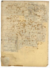
Page 66 of the City Engineer's Plat Book with fourteen plats. Plat 1 features buildings located near the intersection of King Street and Clifford Street. Plat 2 shows lots and structures located near the intersection of "Comings Street" and Wentworth Street. Plat 3 shows a lot and structures located on Pitt Street. Plat 4 shows lots located on a city block between Smith Street and Pitt Street, and between Montague Street and Wentworth Street. Plat 5 shows lots located on a city block between Montague Street and Wentworth Street, and between South Street and Rutledge Street. Plat 6 features a lot located near the intersection of "Comings Street" and Montague Street. Plat 7 shows lots and some structures located near the intersection of Bull Street and Coming Street. Plat 8 shows a lot and buildings located on Bull Street. Plat 9 Shows lots located near the intersection of Smith Street and Boundary Street. Plat 10 shows lots located on a city block between Lynch Street and Rutledge Street, and between Bull Street and Montague Street. Plat 11 shows lots and structures located near the intersection of Pitt Street and Bull Street. Plat 12 is features a lot located at the intersection of Pitt Street and Bull Street. Plat 13 Features lots located near the intersection of Bull Street and Lynch Street. Plat 14 shows lots located on Queen Street.
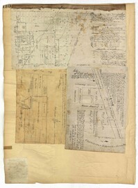
Page 34 of the City Engineer's Plat Book with four plats. Plat 1 shows lots located on South Bay Street. Plat 2 shows land located between Beaufain Street and Queen Street, near Smith Street, Wilson Street, and Franklin Street. Plat 3 shows lots located near Beaufain Street's intersections with Pitt Street and Wilson Street. Plat 4 features a lot and its buildings located on Meeting Street.
Page 50 of the City Engineer's Plat Book with seven plats. Plat 1 shows wharves and other structures located on East Bay Street. Plat 2 shows lots and buildings located on the intersection of Tradd Street and Meeting Street. Plat 3 shows lots located near the intersection of Broad Street and Rutledge Street. Plat 4 shows lots and buildings located near Gibbes Street. Plat 5 shows lots located near the intersection of Society Street and East Bay Street. Plat 6 shows lots and buildings near Broad Street. Plat 7 shows lots located between South Bay Street and the Ashley River, near Legare Street.
Page 130 of the City Engineer's Plat Book with three plats. Plat 1 shows lots located on a city block between Meeting Street and Scarborough Street and between Boundary Street and George Street. Plat 2 shows lots and structures located on East Bay Street. Plat 3 shows lots located on the Cooper River channel of the Charleston Harbor, near Concord Street and Wharf Street.
Page 151 of the City Engineer's Plat Book with two plats. Plat 1 shows lots and structures located on and near Anson Street. Plat 2 shows lots and structures located between Coming Street and the Ashley River Channel, and between Elliott Street and Mill Creek. The plat also shows 50 acres of marsh, several bodies of water, Boundary Street, Pinckney Street, Cannon Street, and President Street.
Page 127 of the City Engineer's Plat Book with four plats. Plat 1 shows lots and wharves, including Accommodation Wharf and Brown's Wharf. Plat 2 shows structures on Anson Street. Plat 3 shows lots located near the intersection of Pinckney Street and Anson Street. Plat 4 shows lots located on and near Gadsden Street, between Pinckney Street and King Street.
Page 52 of the City Engineer's Plat Book with seven plats. Plat 1 features a lot located on Queen Street. Plat 2 shows land between New Street and the Ashley River Channel, including stretches of Tradd Street, Broad Street, New Street, Savage Street, Rutledge Street, and Lynch Street. Plat 2 also shows some marshlands in the area. Plat 3 shows lots located along Greenhill Street, near the intersection with Tradd Street. Plat 4 shows an area similar to Plat 2, with certain buildings and marshlands labelled. Plat 5 shows a lot located on the intersection of Tradd Street and New Street, featuring several buildings and other structures. Plat 6 shows land located near Tradd Street, with marshes and shoals labelled. Plat 7 features lots between Tradd Street and Gibbes street, and has a label reading "City marshland." Plat 7 also shows New Street, Savage Street, and Council Street.