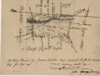
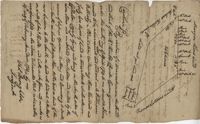
Plan of a tract of 1000 acres of land in Wall Eye Swamp in Craven County [now in parts of Berkeley, Charleston, Georgetown, and Williamsburg counties]. Names associated with this plat are Samuel Cooper, James Sinkler, Peter Sinkler, Isham Moore, John Bremar, and William Bull.
Copy of a plat of 250 acres laid out to Abraham Michau on the north side of Santee River and “now belonging to John Pedro." Names associated with this plat are Abraham Michau, John Pedro, George Hunter and James Glen. Notable geographic locations include the Santee River, Prince Frederick Parish and Georgetown District.
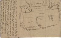
Plat of 53 acres off of Dorchester Road which is divided into lots. Very little details or information. Names associated with this plat are Fitch and Beckman. Notable geographic locations include Dorchester Road.
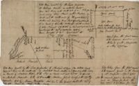
"Jonathan Burnbridge 310 acres certified for him the 24th day of December 1805. Pursuant to a warrant from Artemar B. Darby D. S. G. dated the 20th day of December 1805 having admeasured and laid out unto Jonathan Bunbridge a tract of land containing 310 acres situated in Charleston District bounded by a lain [sic] running NW and NW by land of Ralph Izard NE on land of William Stephens NE and E on land not known and by all other lines on land of Doctor William Stephens and hath such form and marks as the above plat represents Surveyed the 21 day of December 1805 Michael Byrne Dep Surveyor." Names associated with this plat are Jonathan Darby Bunbridge, B. Artemar, Ralph Izard, William Stepens, Dr. William Stephens, and Michael Byrne. Notable geographic locations include St. Bartholomew’s Parish.
“Plan of parcel of land of late belonging to John Jones and now sold and conveyed by the said Jones to James Carsen for 850 acres but the request of the said Carsen. The said tract of land has been resurveyed and find it to contain but 805 acres of land or there about, so that the original survey must have taken in 45 acres of the marshes of Bohicket River...true copy taken from the original plat in the property of Mr. William Carsen in June 1794." Names associated with this plat are John Carsen, John Jones, James Carsen, William Chambers, James Young, Thomas Winborns, McDoul, Abigail Winborn, John Gibbs, Wilkins, and William Carsen. Notable geographic locations include St. John's Parish, Bohicket River, Wadmalaw River and Johns Island.
Sipros Openen Plantation, 342 acre plantation in Colleton county near Stono River, an island plantation, shows property lines and no land detail, also shows surrounding area outside of the plantation. Names associated with this plat are William Willersby, Alens [?], Thomas Lattson, Robert Murens, Ambers Helle, Charles Craven, Hells and Thomas Broughton. Notable geographic locations include Colleton County, Stono River, Sipros Opener, and Johns Island.
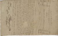
Plat of 130 acres on the Pee Dee River. Explains the plat and the surrounding area, drawing itself has little detail. Names associated with this plat are William Swinton, Joseph LaBruce, John White, James St. John, Elias Hopkin, and Thomas [?]. Notable geographic locations include the Pee Dee River, Black River, Weehaw Plantation, Kensington Plantation, Weehaw Creek, Georgetown, and Craven County [now in parts of Berkeley, Charleston, Georgetown, and Williamsburg counties].
Plat of 210 acres belonging to William Williams surrounded by land owned by Thomas Pinckney, Christopher Smith, and Thomas Dalton. No other notes written as to the location of the land. Very little detail on the plat included. Names associated with this plat include William Williams, Thomas Pinckney, Christopher Smith, Thomas Daulton, Thomas Smith, Edward Weekly, William Dry, Ralph Izard, Charles Fields, John Jolhimns [?], Thomas Broughton, and Hannah English aka Hannah Williams.
600 acres plot granted to Richard Floyd residing in Colleton County lying and budding on the southside of Bohickett Creek, shows surrounding property names and creeks, shows land notes but no land type or details. Also shown is 200 acres granted by the Lords Proprietors by William Arnell in Colleton County. Names associated with this plat are Richard Floyd, Graeme [?], the Lords Proprietors, Michael Ranell, Thomas Broughton, Robert Gibbes, William Atnel, Timothy Bellemey, Anthony Matthews, Ambross Hill, John Prescot and Neufville. Notable geographic locations include John's Island, Bohickett Creek, Colleton County, Ambrose Hill, Stono River, and Keywa [Kiawah] Island.
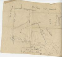
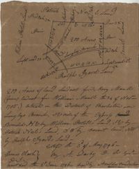
Plat includes Langley Branch Road going through plat as well as a road. Plat consists of 200 acres. Names associated with this plat are Mary Manlt, William Manlt, William Postell, Patrick Neel, Ralph Izard, Thomas Clark, A. Darby, Amoldus Vanderhorst, Margaret Manlt and W.S. Smith. Notable geographic locations include St. George’s Parish, Langley Branch, Cypress Road, Dorchester, Cypress Swamp, and Charleston District.