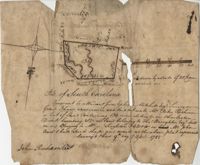
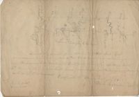
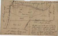
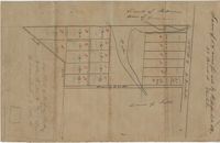
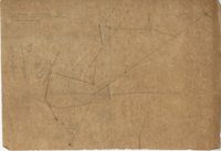
"Pursuant to a Warrant for, [?] Mitchell Esquire Surveyor General Sha [?] Ad measured and laid out unto William Peter Reahimer a tract of land containing 136 acres situated in Charleston District, bounding SW on land belonging to Thomas Broughton Esquire South on land belonging to William Singleton [?] on Mr. John Ansil and has such shape and mark as the above plat represents Surveyed 9th day of April 1785." Includes two water sources dividing the property. Names associated with this plat are William Peter Redhimer, Thomas Broughton, William Singleton, John William Ansil, and John Richardson.
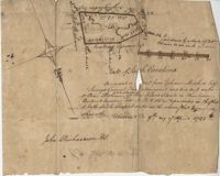
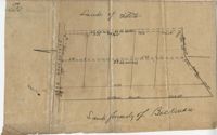
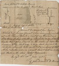
Persuant to [?] from Ephraim Mitchell Esquire Surveyor General that admeasured and laid out un to William Peter Redhimer a tract of land containing 97 acres of land situated in Charleston District bounding NW [?] as represented in the plat and hath such shape and marks as the above plat Surveyed this 9th day of April 1785. Names associated with this plat are William Peter Redhimer, John Richardson, Colonel Isaac Motte, Thomas Singleton, Reating Simoner, Ephraim Mitchell and Keating Simone.
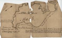
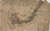
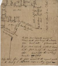
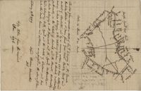
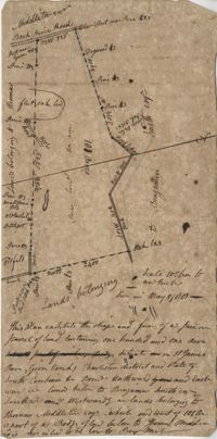
BACK: John Griggs 1220 acres Charleston 1 June 1786 [?] Peter Freneau. FRONT: “Pursuant to a warrant from Ephraim Mitchell Esquire Surveyor General and laid out unto John Griggs a Tract of land containing one thousand two hundred and twenty acres (1220) situated in St. Bartholomew's Parish Charleston District and has such shape form and marks as the above plat represents. Likewise butting and bounding as the said plat specifies." Names associated with this plat are John Griggs, Ephraim Mitchell, Daniel Doyley, Edmund Belling, Gochran, Gabriel Stock, Gochnan [?], and Peter Freneau [?]. Notable geographic locations include the Ch[?]aw River, Charleston District and St. Bartholomew's Parish.
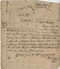
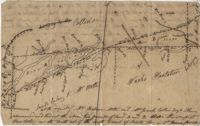
“Pursuant to a War- Mitchell Esquire Surveyor General [having been] admeasured and laid out unto John Griggs a tract of land containing one hundred and ninety (190) acres situated in Charleston District on the South side of Ashepoo River Bounded South-Westwardly on Lands of [?] Ladson, and part on Mr. Smiths lands on all other sides upon the said Ashepoo River and hath such form and marks as the above plat represents. Certified...this 26 day of June 1786 William Tate D. S." Names associated with this plat are John Griggs, William Tate, Ladson, Smith, Peter Freneau, and Ephraim Mitchell.
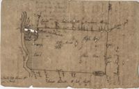
Plat contains 360 acres. Plat includes sketch of house. Names associated with this plat include John Glen, Ephraim Mitchell, Crip, Daniel Cannon, and John Richards. Notable geographic locations include St. James Parish, Goose Creek and Charleston District.
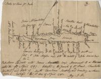
77 acres of marsh in two pieces situated on Johns Island along Stono River. Names associated with this plat are J.N. Mainville, Thomas Simmons, James Nicholas, Guervin, William Simmons and Marshall. Notable geographic locations are the Stono River, Johns Island, Charleston District, and Marshalls Creek.
Plan of a tract of land on the NE side of Edisto River called Riverside Plantation and contains 1100 acres belonging to estate of Thomas Ferguson lately sold to Martin. Names associated with this plat included Benjamin Berry, Bull, Martin, John Eberley, Edward Perry, and Thomas Ferguson. Notable geographic locations include St. Paul's Parish, the Edisto River, Parkers Ferry, Public Road to Charleston, Riverside Plantation, and Charleston District.
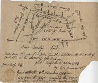
Plat contains 310 acres layer out for John Gamble granted November 6, 1706. Plat contains location of house. Names associated with this plat are John Gamble, Gideon Fishero, Amos Donoly, John Deas, Francis Cobia, Purull, and F. Bremar.
Copy of a plan of a plantation or tract of land lately sold to Isaac Holmes by James Legare lying on Johns Island, Charleston District from a plan annexed to Arleas from Thomas Legare and annexed to Isaac Holmes 1784. 380 acres. Names associated with this plat are Thomas Legare, James Legare, and Isaac Holmes. Notable geographic locations include Charleston District and Johns Island.
Copy of a plat of 490 acres owned by Francis Smith annexed to the lands owned by Laughlin McIntosh. Names associated with this plat are Francis Smith, Laughlin McIntosh, Beadon Colonel, Captain Hutchinson, and Thomas Fleming. Notable geographic locations include St. Bartholomew's Parish, Chickaw and Charleston District.
Plan of a parcel of land situated on Johns Island and containing 86 1/2 acres. Being part of a body of land belonging to Thomas Mathews. Bounded northwardly by a public road, eastwardly on James Legare's land, and southwardly on land belonging to Isaac Holmes and Thomas Legare. Intended to be conveyed to Isaac Holmes. Names associated with this plat are Thomas Mathews, Isaac Holmes, Thomas Legare, William Stanyarn, Matthews and James Legare.
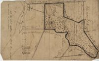
Plat of 237 acres belonging to Rob Reeves Gibbes. Detailed marsh and high land along with the location and outline of a house. Names associated with this plat are Robert Reeve Gibbes, Nathaniel Heyward, John Gibbes, Thomas Gibbes, and Lewis Gibbes. Notable geographic locations include the Combahee River, Tupelo Swamp, and Charleston District.
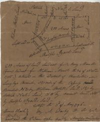
Plat includes Langley Branch Road going through plat as well as a road. Plat consists of 200 acres. Names associated with this plat are Mary Manlt, William Manlt, William Postell, Patrick Neel, Ralph Izard, Thomas Clark, A. Darby, Amoldus Vanderhorst, Margaret Manlt and W.S. Smith. Notable geographic locations include St. George’s Parish, Langley Branch, Cypress Road, Dorchester, Cypress Swamp, and Charleston District.
Plat contains 420 acres But is to the estate of Fulmer and Shubrick and to Shubreek and Hewart also bounding to Hapensack and Izard. Plat includes the location of the house and paths connecting the property to its neighbors. Names associated with this plat include William Conrade Heekeley, Shubrick, Fulmer, Hewart, Hapensack, Ralph Izard, and Thomas Abernethie. Notable geographic locations include St. James Parish, Goose Creek, Wolf Castell, Berkeley County, and Charleston District.
128 acres situated in the Charleston district unto James Maxwell situated in the parish of St. Paul, Charleston District April 1, 1797. Names associated with this plat include James Maxwell, Jane Ladson, Smith, John Boyles, John Somers and Brigdon Smith. Notable geographic locations include St. Paul's Parish, Jerico Plantation, Bretton Hall Plantation, Bay Swamp, and Charleston District.
"Release from Thomas Osborn a Sheriff Charleston District to Philip Hart dated 6 October 1794 for a tract of land measuring and Containing 500 acres more or less situated lying and being on the Cypress Swamp in the district of Charleston Butting and Bounding Westwardly on land now or late the property of David Manll. Southwardly on lands of John Conard, Eastwardly on lands of Thomas Waring and Northeastwardly on lands belonging to Major James Postell - Sold under [?] in the property of William Doweth." Names associated with this plat are Thomas Osborn, William Dewitt, Hart, David Manll, John Conrad, Thomas Waring, Philip Hart, James Postell, and William Doweth. Notable geographic locations include St. George Parish, Cypress Swamp and Charleston District.
"Jonathan Burnbridge 310 acres certified for him the 24th day of December 1805. Pursuant to a warrant from Artemar B. Darby D. S. G. dated the 20th day of December 1805 having admeasured and laid out unto Jonathan Bunbridge a tract of land containing 310 acres situated in Charleston District bounded by a lain [sic] running NW and NW by land of Ralph Izard NE on land of William Stephens NE and E on land not known and by all other lines on land of Doctor William Stephens and hath such form and marks as the above plat represents Surveyed the 21 day of December 1805 Michael Byrne Dep Surveyor." Names associated with this plat are Jonathan Darby Bunbridge, B. Artemar, Ralph Izard, William Stepens, Dr. William Stephens, and Michael Byrne. Notable geographic locations include St. Bartholomew’s Parish.
Plat of 42 acres in St. George’s Parish belonging to Nathaniel Bradwell. Very little detail included with the plat. Names associated with this plat include Nathaniel Bradwell, John B. Giradeau, E.G. Montagu, John Barker, and Peter Haskins.
Small description of a 264 acre land, near Wappoo Creek, including land description. Names associated with this plat are John Schnerlie, Thomas S. Jones, and Edwin R. Dorrill. Notable geographic locations include the Ashley River, Wappoo Creek, Ashley Bridge Ferry Road, and Charleston District.
Plat of 19 acres in St. Andrew’s Parish. A corn field is noted as is a public road along with the neighboring property owners. Little other detail. Names associated with this plat are James C. Perry, Cook, Sault, Benjamin, F.R.N. [?] Smith, Dinzhals [?], S. Charles, and Cattell.
Plat of 288 acres of land situated on Wadmalaw Island. Names associated with this plat are William Weston, Jonathan Runnel, James Clarks, Benjamin Allston [?], and Henry Treads. Notable geographic locations include Wadmalaw River, Wadmalaw Island, Bain Bluff, and Charleston District.
Plat of 640 acres of land belonging to Thomas Roberts situated in Berkeley County on the Cooper River bounding to the North and NE on land lad out to Nicholas Aremile to the south and SW on lands of Robert Miles and all other sides on vacant land. Names associated with this plat are John Berry, Ephraim Mitchell, Thomas Roberts, Nicholas Roberts, Nicholas Aremile, Robert Miles, William Gilbert, Barfield Homan and John Diamond. Notable geographic locations include the St. John's Parish, Cooper River, Berkeley County and Charleston District.
Plan of 101 acres in St. James Parish, Goose Creek belonging to Abram Jones. Details include roads, ports, banks, trees and a field. Names associated with this plat are Abram Jones, Thomas Middleton, and Major Benjamin Smith. Notable geographic locations include Goose Creek, Charleston District, and Black River Road.
Two parcels of land (A & B) on the south side of the south branch of the Santee River in St. James Parish, Charleston District. Names associated with this plat include Rebecca Motte and Jonah Collin. Notable geographic locations include Washo Plantation, St. James Parish, Santee and Charleston District.