Search Home
Search in
search for
Simple Search
Page Content Search
Title Search
Creator Search
Subject Search
Search
search icon
Search
Search Constraints
Start Over
You searched for:
Media Type
Maps
✖
Remove constraint Media Type: Maps
Subject (Geographic)
Charleston (S.C.)
✖
Remove constraint Subject (Geographic): Charleston (S.C.)
Date Range (beta)
1780
to
1799
✖
Remove constraint Date Range (beta): <span class="from" data-blrl-begin="1780">1780</span> to <span class="to" data-blrl-end="1799">1799</span>
1
-
7
of
7
Sort
by Relevance
Relevance
Title
Date (Newest)
Date (Oldest)
Number of results to display per page
10
per page
10
per page
20
per page
50
per page
100
per page
View results as:
list icon
List
masonry icon
Masonry
Search Results
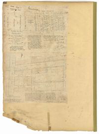
City Engineers's Plat Book, 1671-1951, Page 12
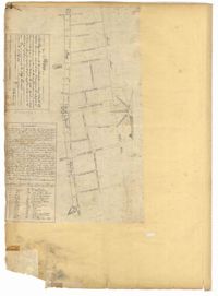
City Engineers's Plat Book, 1671-1951, Page 14
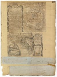
City Engineers's Plat Book, 1671-1951, Page 207
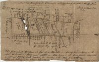
Plat in St. John's Parish 1789
Sandy Island Plat 1789
Plat on Stono Swamp 1793
Plat in St. Andrew's Parish 1797
Limit your search
Collection
John McCrady Plats and Deeds Collection
4
City Engineers's Plat Book, 1671-1951
3
Contributing Institution
South Carolina Historical Society
4
The Charleston Archive at CCPL, City of Charleston
3
Media Type
Maps
✖
[remove]
7
Subject (Topic)
Conveyancing--South Carolina, Maps, Surveying--South Carolina
4
Cadastral maps, Surveys
3
Subject (Geographic)
Charleston (S.C.)
✖
[remove]
7
Date
1789
2
1780, 1671
1
1787
1
1793
1
1797
1
1799, 1819
1
Date Range (beta)
1780
to
1799
✖
[remove]
7
1780
to
1781
1
1782
to
1783
0
1784
to
1785
0
1786
to
1787
1
1788
to
1789
2
1790
to
1791
0
1792
to
1793
1
1794
to
1795
0
1796
to
1797
1
1798
to
1799
1
Current results range from
1780
to
1799
Date Range (beta) range begin
Date Range (beta) range end
View larger »