Page 112 of the City Engineer's Plat Book with five plats. Plat 1 shows lots and structures located on the north side of Tradd Street. Plat 2 shows lots located on the east side of Savage Street. Plat 3 shows lots located on King Street. Plat 4 shows lots located between Broad Street and Tradd Street, and between Lynch Street and the Ashley River. Plat 5 shows lots and structures located near the intersection of King Street and Broad Street.
Page 111 of the City Engineer's Plat Book with one plat. This plat shows lots located near the intersection of East Bay Street and Broad Street. It also shows a building labelled "EXCHANGE," and Gillon Street.
Page 24 of the City Engineer's Plat Book with three plats. Plat 1 shows lots located near King Street, Meeting Street, Wolf Street, March Lane, and Reid Street, including a portion of land labelled "Old fish pond low & broken land" and large label reading "Part of Hampstead." Plat 2 shows lots and features near the Charleston Harbor on the Cooper River, Boundary Street, Charlotte Street, Washington Street, and East Bay Street, and notes the "High Water Mark at Common Tides." Plat 3 shows lots located Meeting Street, Elizabeth Street, Ann Street, John Street, "Chapple Street," Alexander Street, and Washington Street, including a lot labelled "Tobacco Inspection."
Page 26 of the City Engineer's Plat Book with two plats. Plat 1 is a plan for a public square located near the intersection of Pinkney Street and Boundary Street, and shows a creek. Plat 2 features a lot located on the Ashley River channel and "Commings Creek," located near the intersections of Pinckney Street and Boundary Street, and Bull Street and Rutledge Street. Plat 2 also labels a pond, an island, and "Cannon's Point." Plat 3 shows lots located between Boundary Street and Bull Street, near the intersections with Barre Street, Gadsden Street, Lynch Street, Rutledge Street, Pitt Street, and "Comming Street."
Page 29 of the City Engineer's Plat Book with three plats. Plat 1 shows lots and structures located near Calhoun Street, Rutledge Street, Lynch Street, Gadsden Street, Lucas Street, and Bennett Street, including a lot labelled "Public Square," a creek, and a building labelled "Saw Mill." Plat 2 shows land located near the intersection of West Bay Street and a body of water labelled "Mill Pond." Plat 3 shows land located near the Ashley River channel and a road labelled "Causeway Leading to Rice Mill."
Page 28 of the City Engineer's Plat Book with three plats. Plat 1 shows lots located near Calhoun Street, Bull Street, South Street, Ashley Street, Rutledge Street Lynch Street, and Bennett Street. Plat 1 also shows lots labelled "The Mall," and Lots Belonging to Sundry Persons. Plat 2 shows lots and buildings located near the intersection of Calhoun Street and Lucas Street, including lots labelled "Mansion Lot" and "Left for a Public Square." Plat 3 shows lots and buildings located near Bee Street, between Ashley Street and Rutledge Street.
Page 34 of the City Engineer's Plat Book with four plats. Plat 1 shows lots located on South Bay Street. Plat 2 shows land located between Beaufain Street and Queen Street, near Smith Street, Wilson Street, and Franklin Street. Plat 3 shows lots located near Beaufain Street's intersections with Pitt Street and Wilson Street. Plat 4 features a lot and its buildings located on Meeting Street.
Page 27 of the City Engineer's Plat Book with five plats. Plat 1 shows lots located on Broad Street, between the intersections with East Bay Street and State Street. Plat 2 shows lots on Chapel Street. Plat 3 shows lots near Savage Street and Tradd Street. Plat 4 shows lots on Savage Street. Plat 5 shows lots near the intersection of Broad Street and East Bay Street.
Page 38 of the City Engineer's Plat Book with two plats. Plat 1 shows lots located near Calhoun Street, some buildings, "Lots Belonging to Sundry Persons," and "The Mall." Plat 1 also shows Bennett Street, Ashley Street, Rutledge Street, Gadsden Street, and Lynch Street. Plat 2 features a lot on Smith Street.
Page 37 of the City Engineer's Plat Book with three plats. Plat 1 shows lots located on Herriot Street. Plat 2 shows lots located on the block between Rutledge Street and Smith Street, and Morris Street and Radcliffe Street. Plat 3 shows lots and buildings located on King Street, with a stretch labelled "Unitarian Church Land."
Page 25 of the City Engineer's Plat Book with two plats. Plat 1 shows lots and buildings near Guignard Street, located between East Bay Street and "Rapers Ally." Plat 2 shows lots located near Cumming Street, between Shepherd Street and Line Street.
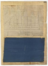
Page 215 of the City Engineer's Plat Book with two plats. Plat 1 shows land located between Calhoun Street and Bull Street, and between Lynch Street and Rutledge Street. Plat 2, located inside a folding insert, shows land along Moultrie Street. Plat 2 also includes Hanover Street, Hill Street, Huger Street, Nassau Street, Meeting Street, Hampton Street, King Street, a lot labeled "Chas. Gas Light Co.," labels for high land, labels for marsh land, and a structure located on Hampton Street.
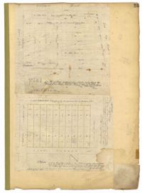
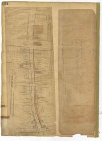
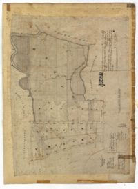
Page 212 of the City Engineer's Plat Book with three plats. Plat 1 shows lots located between Broad Street, Tradd Street, and Savage Street. Plat 2 shows lots and structures located near the intersection of Tradd Street and Chisolm Street, including wharves, a storehouse, a rice mill, an engine house, and a saw mill. Plat 3 shows lots, structures, and geographic features located between New Street and the Ashley River. Plat 3 also includes Tradd Street, Savage Street, Rutledge Street, Lynch Street, and a large stretch of marshland.
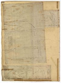
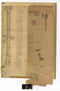
Page 213 of the City Engineer's Plat Book with two plats. Plat 1 features lots located between Savage Street and Chisolm Street, and between Tradd Street and Broad Street. Plat 1 also shows New Street, Rutledge Avenue, Lynch Street, Trapmann Street, and a lot labelled "Chisolm Mill Property." Plat 2 shows Calhoun Street's intersections with Lynch Street and Ashley Street.
Page 222 of the City Engineer's Plat Book with two plats. Plat 1 shows lots and structures located along East Bay Street, between Hasell Street and an unlabeled street. Plat 1 also shows Pritchard Street, Pinckney Street, Guignard Street, and Market Street. Plat 2 shows lots and structures located between Church Street and land owned by the Dry Dock Company. Plat 2 also shows Hayne Street, Anson Street, Guignard Street, and East Bay Street.
Page 228 of the City Engineer's Plat Book with two plats. Plat 1 shows the ground elevation near Mount Pleasant Street, between the Ashley River Marsh and the Cooper River Marsh. It also shows where Mount Pleasant Street intersects with Meeting Street and King Street. Plat 2 shows lots and structures located on and near Magazine Street, between Franklin Street and Smith Street.
Page 224 of the City Engineer's Plat Book with one plat. The plat features lots and structures belonging to a refining company. It also shows several streams, a right-of-way for a rail line, America Street, Hanover Street, Centre Street, and Meeting Street.
Page 220 of the City Engineer's Plat Book with one plat. The plat shows lots extending from the Ashley River, past Lucas Street. The plat also shows Doughty Street, Calhoun Street, President Street, U. S. Arsenal Square, and several structures.
Page 226 of the City Engineer's Plat Book with one plat. It shows lots located between Rutledge Avenue and King Street, and between Race Street and Sheppard Street.
Page 225 of the City Engineer's Plat Book with one plat. The plat shows lots and marsh located east of King Street and north of Line Street. It also shows Meeting Street.