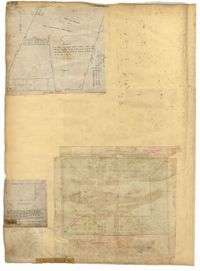
Page 146 of the City Engineer's Plat Book with three plats. Plat 1 shows lands located on and near the intersection of East Bay Street and Hasell Street. Plat 2 features a lot located on the north side of John Street, between Meeting Street and King Street. It also shows a lot labelled "So. Ca. RR. Co." Plat 4 shows a park and buildings located between King Street and Meeting Street, and between Calhoun Street and Hutson Street.
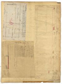
Page 147 of the City Engineer's Plat Book with three plats. Plat 1 shows lots located between King Street and land owned by the South Carolina Railroad Company. Plat 2 shows lots and structures located between Charlotte Street and Calhoun Street, and between Washington Street and Meeting Street. It also shows Alexander Street, Elizabeth Street, and Henrietta Street. Plat 3 shows lots and structures located on and near the intersection of President Street and Cannon's Court.
Page 159 of the City Engineer's Plat Book with five plats. Plat 1 shows lots and structures located on East Bay Street, between Hasell Street and Cumberland Street. Plat 2 features a lot located on King Street, between Hudson Street and Tobacco Street. Plat 3 shows lots located between State Street and East Bay Street, located near their intersections with Market Street. Plat 4 shows lots located along "Horlbecks Alley," between King Street and Meeting Street. Plat 5 shows lots located on Short Street, between Mazyck Street and Franklin Street.
Page 160 of the City Engineer's Plat Book with four plats. Plat 1 shows a stretch of Mazyck Street, near its intersections with Queen Street and Short Street. Plat 2 shows lots and structures located on and near Reid Street, between Drake Street and Bay Street. Plat 4 shows lots and structures located between Nassau Street and Meeting Street, and between Stewart Street and Johnson Street.
Page 162 of the City Engineer's Plat Book with three plats. Plat 1 shows land located near Payne Street with several streams. Plat 2 shows lots located in the Village of Hampstead, located near America Street. The plat also shows marshland and streams. Plat 3 has numerous tears and holes. Plat 4 shows lots and structures located between Meeting Street and Lynch Street.
Page 163 of the City Engineer's Plat Book with two plats. Plat 1 shows lots and structures located on Friend Street, near its intersections with Queen Street, Broad Street, and an unlabeled street. Plat 2 shows lots located on King Street, near where it intersects with Broad Street.
Page 28 of the City Engineer's Plat Book with three plats. Plat 1 shows lots located near Calhoun Street, Bull Street, South Street, Ashley Street, Rutledge Street Lynch Street, and Bennett Street. Plat 1 also shows lots labelled "The Mall," and Lots Belonging to Sundry Persons. Plat 2 shows lots and buildings located near the intersection of Calhoun Street and Lucas Street, including lots labelled "Mansion Lot" and "Left for a Public Square." Plat 3 shows lots and buildings located near Bee Street, between Ashley Street and Rutledge Street.
Page 27 of the City Engineer's Plat Book with five plats. Plat 1 shows lots located on Broad Street, between the intersections with East Bay Street and State Street. Plat 2 shows lots on Chapel Street. Plat 3 shows lots near Savage Street and Tradd Street. Plat 4 shows lots on Savage Street. Plat 5 shows lots near the intersection of Broad Street and East Bay Street.
Page 38 of the City Engineer's Plat Book with two plats. Plat 1 shows lots located near Calhoun Street, some buildings, "Lots Belonging to Sundry Persons," and "The Mall." Plat 1 also shows Bennett Street, Ashley Street, Rutledge Street, Gadsden Street, and Lynch Street. Plat 2 features a lot on Smith Street.
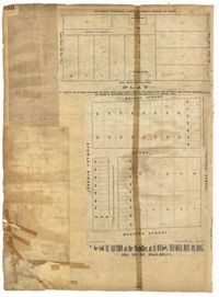
Page 37 of the City Engineer's Plat Book with three plats. Plat 1 shows lots located on Herriot Street. Plat 2 shows lots located on the block between Rutledge Street and Smith Street, and Morris Street and Radcliffe Street. Plat 3 shows lots and buildings located on King Street, with a stretch labelled "Unitarian Church Land."