Search
« Previous |
151 - 200 of 7,766
|
Next »
Search Results
Description:
Document describing the Housing Bureau of the Civic Services Committee.
Description:
Article "The Development of Charleston Architecture" by Albert Simons that appeared in the News & Courier, published by the SC Chapter, American Institute of Architects.
Description:
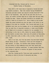
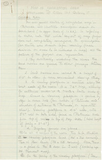
Summary of an interview done with Mrs. Kinloch and Mr. Grice regarding parking and traffic conditions between 1939 and 1943.
Description:
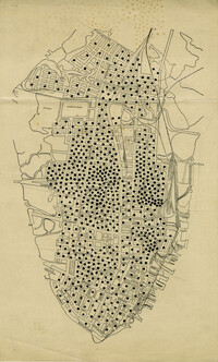
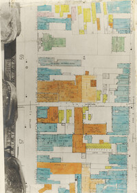
Map of peninsula.
Description:
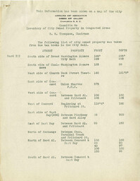
List of city owned property in congested traffic areas compiled by the committee on "Inventory of City Owned Property in Congested Areas."
Description:
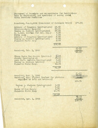
Statement of Receipts and expenditures for the "This is Charleston" Exhibition.
Description:
"General Plan" for "Map of Charleston Area" exhibit at the Gibbes Art Gallery.
Description:
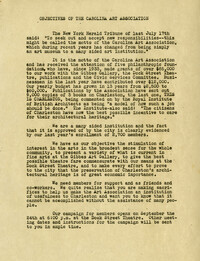
Report entitled "Objectives of the Carolina Art Association."
Description:
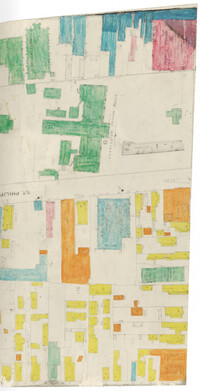
Color-coded map of area between Meeting Street and King Street, bisected by Horlbeck Alley..
Description:
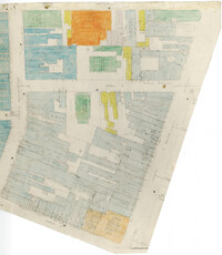
Color-coded map of area around St. Philip Street at Calhoun Street near the Charleston Orphan House.
Description:
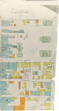
Color-coded map of Archdale Street where Clifford Street, Beresford, and Princess intersect.
Description:
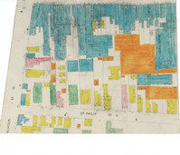
Color-coded map of area bounded by Wentworth Street, Meeting Street, Market Street, and King Street.
Description:
Color-coded map of area around St. Philip Street near the Charleston Orphan House.
Description:
Notes from "Permanent Recreation Areas in Real Estate Developments" by Mary Beattie Brady.
Description:
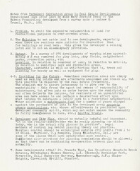
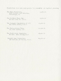
Document listing foundations that have made grants for community and regional planning.
Description:
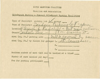
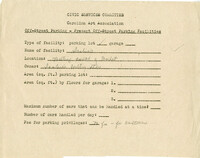
Off-street parking facilities survey filled out for Southern Railroad.
Description:
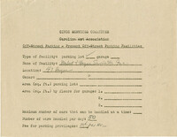
Off-street parking facilities survey filled out for Big Star Store.
Description:
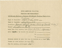
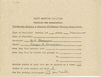
Off-street parking facilities survey filled out for Condon's Parking lot.
Description:
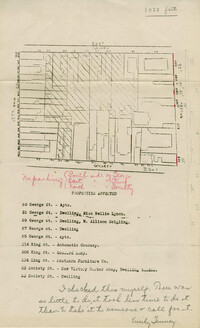
Map of area bounded by Society, Meeting, George, and King Street.
Description:
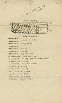
Map of area bounded by Market, King, Princess, and Archdale Street.
Description:
Map of area bounded by Jacob's Alley, Archdale, Clifford, and King Street.
Description:
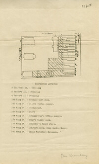
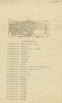
Map of area bounded by Clifford, King, Beresford, and Archdale Street.
Description:
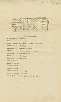
Map of area bounded by Princess, King, Beresford, and Archdale Street.
Description:
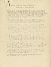
A speech entitled "Off Street Parking."
Description:
A speech entitled "How a Community Plans Together."
Description:
Responses to parking questionnaire by Arthur La Coste (South Carolina National Bank).
Description:
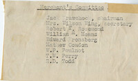
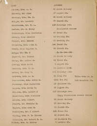
Membership list for the Merchant's Committee.
Description:
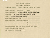
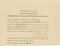
Off-street parking facilities survey filled out for Filling Station and Tire Sales Room.
Description:
Off-street parking facilities survey filled out for C.R. Batson's Esso Service Station.
Description:
Off-street parking facilities survey filled out for a parking lot on 2-4 State Street.
Description:
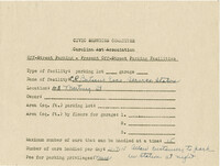
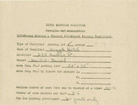
Off-street parking facilities survey filled out for E. G. Harlston.
Description:
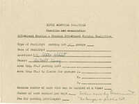
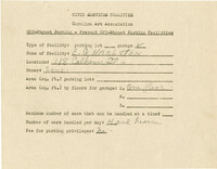
Off-street parking facilities survey filled out for Argyle Hotel.
Description:
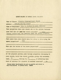
Church owned property questionnaire filled out for Circular Congregation Church on 138-150 Meeting Street.
Description:
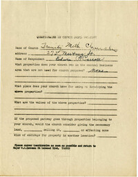
Church owned property questionnaire filled out for Trinity Methodist Church located on 273 Meeting Street.
Description:
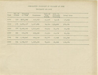
Table of Comparative Statement of Property at Risk Insurance and Loss for the years 1900, 1910, 1920, 1930, 1940, and 1942.
Description:
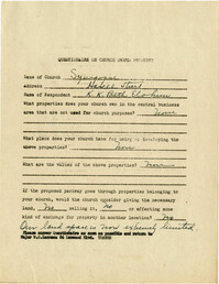
Church owned property questionnaire filled out for Synagogue on Hasell Street.
Description:
Off-street parking facilities survey filled out for warehouses and garage on 113 Church Street.
Description:
Off-street parking facilities survey filled out for McAlister Esso Service Station.
Description:
Off-street parking facilities survey filled out for warehouse at 4-11 Chalmers Street.
Description:
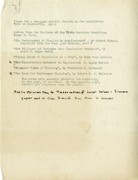
"Items for a two page special feature" on the "This is Charleston" exhibit.
Description:
Results of the off-street parking facilities survey in Mrs. Harry M. Rubin's report.
Description:
Document with a list of names and addresses, the purpose of which is not indicated. May be mailing list for Whitelaw Letter 2.
Description:
Statement regarding the Civic Services Committee's efforts regarding war memorials in Charleston.
Description:
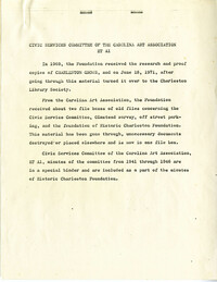
Description and index of Civic Services Committee materials that were taken from Carolina Art Association and incorporated into the files of what became Historic Charleston Foundation. Also includes a list of materials "now on deposit at SC Historical Society," and the finding aid to the Civic Services Committee records that are still held at the Gibbes Museum of Art.
Description:
Community Development Council document listing new personnel, Board of Governors, technical section, and membership.
Description:
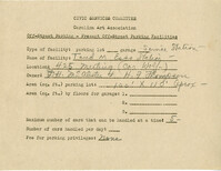
Off-street parking facilities survey filled out for Taud M. Esso Station.
Description:
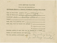
Off-street parking facilities survey filled out for Hood-Myers Electric Co.
Description:
Off-street parking facilities survey filled out for Pure Service Station.
Description:
Off-street parking facilities survey filled out for Scobies Poultry Store.
Description:
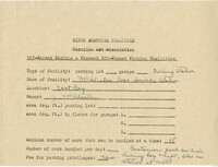
Off-street parking facilities survey filled out for George Street Parkway.