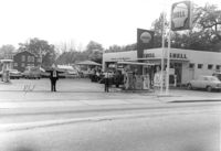
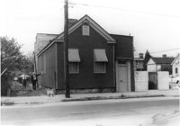
Shell gas station on site affected by the construction of Interstate 26 (I-26). Address: 1227 King Street. Surveyor notations on back of photo: "Dkt.: 10.503. Property owner: Shell Oil Co. Tract: 14-A. Station: 9+50 Rt. (Mt. Pleasant St.). Date: Apr. 20, 1965." [See collection description for explanation of surveyor notations.]
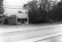
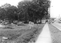
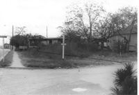
Roadside building and lot on site affected by the widening of U.S. Route 17. Presumably located in Mount Pleasant or vicinity. Surveyor notations on back of photo: "Dkt.: 10.439. Property owner: Morris C. Poulas. Tract: 2. Station: 228+20 Rt. Date: Jul. 22, 1965. Proximity." [See collection description for explanation of surveyor notations.]
Roadside building and lot on site affected by the widening of U.S. Route 17. Presumably located in Mount Pleasant or vicinity. Surveyor notations on back of photo: "Dkt.: 10.439. Property owner: Morris C. Poulas. Tract: 2. Station: 228+20 Rt. Date: Jul. 22, 1965. Proximity." [See collection description for explanation of surveyor notations.]
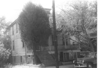
House (front and side view) on site affected by the construction of Interstate 26 (I-26). Address: 7 Carolina Street. Surveyor notations on back of photo: "Dkt.: 10.517. Property owner: Carrie M. Leaphart. Tract: 127. Station: 22+20 Rt. (Line "1"). Date: November 4, 1965. Side view of building and lot that is entirely in R/W." [See collection description for explanation of surveyor notations.]
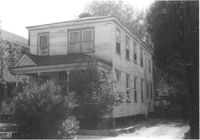
House on site affected by the construction of Interstate 26 (I-26). Address: 5 Carolina Street. Surveyor notations on back of photo: "Dkt.: 10.517. Property owner: I.S. Keith Ellsworth, Sr. Tract: 128. Station: 22+00 Rt. (Line "1"). Date: November 4, 1965. View of subject building and lot entirely in R/W." [See collection description for explanation of surveyor notations.]
Sign "Opening soon - New 7-11 Food Store," on site affected by the widening of State Road 31 (Reynolds Avenue). Surveyor notations on back of photo: "Dkt.: 10.541. Property owner: Morris P. Sokol, et al. Tract: 1. Station: 2+80 Lt. Date: Apr. 20, 1965. Portion of office building in R/W." [See collection description for explanation of surveyor notations.]
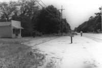
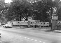
Entrance to Idamor Trailer Park and Apartments, on site affected by the widening of State Road 31 (Reynolds Avenue). Surveyor notations on back of photo: "Dkt.: 10.541. Property owner: Morris P. Sokol, et al. Tract: 1. Station: 3t-4t Lt. Date: Apr. 20, 1965. Taken from southeast side. [See collection description for explanation of surveyor notations.]
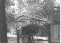
Garage behind house on site affected by the construction of Interstate 26 (I-26). Address: 1 Carolina Street. Surveyor notations on back of photo: "Dkt.: 10.517. Property owner: I.S. Keith Ellsworth, Sr. Tract: 128. Station: 22+50 Rt. (Line "1"). Date: November 4, 1965. Garage entirely in R/W." [See collection description for explanation of surveyor notations.]
House on site affected by the construction of the Crosstown. On Cooper Street; address unknown. Surveyor notations on back of photo: "Dkt.: 10.518. Property owner: Louise McLead Drayton. Tract: 30-B. Station: 14+60 Lt. (Cooper Street). 41+70 Rt. (U.S. Rt. 17). Date: Apr. 20, 1965. Partially in R/W." [See collection description for explanation of surveyor notations.]
Lot on Spruill Avenue at intersection of Hugo Avenue, on site affected by the construction of Interstate 26 (I-26). View of street corner. House in photo 1103 in background. Surveyor notations on back of photo: "Dkt.: 10.490. Property owner: Bunch Realty Co. Tract: 28-D. Station: 48+00 Rt. (Spruill Ave.) Date: November 4, 1965. Take includes entire lot. Range poles on new R/W." [See collection description for explanation of surveyor notations.]