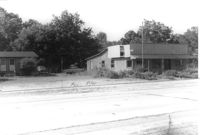
Buildings on site affected by the widening of U.S. Route 17. Presumably located in Mount Pleasant or vicinity. Surveyor notations on back of photo: "Dkt.: 10.439. Property owner: A.J. Ashley. Tract: 19. Station: 241+00 Lt. Date: Jul. 22, 1965. Range poles on pres. & 75' R/W - front of both bldg." [See collection description for explanation of surveyor notations.]
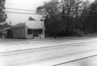
Roadside building and lot on site affected by the widening of U.S. Route 17. Presumably located in Mount Pleasant or vicinity. Surveyor notations on back of photo: "Dkt.: 10.439. Property owner: Morris C. Poulas. Tract: 2. Station: 228+20 Rt. Date: Jul. 22, 1965. Proximity." [See collection description for explanation of surveyor notations.]
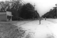
Roadside building and lot on site affected by the widening of U.S. Route 17. Presumably located in Mount Pleasant or vicinity. Surveyor notations on back of photo: "Dkt.: 10.439. Property owner: Morris C. Poulas. Tract: 2. Station: 228+20 Rt. Date: Jul. 22, 1965. Proximity." [See collection description for explanation of surveyor notations.]
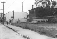
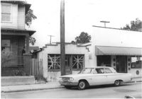
Building (rear view) and lot on site affected by the construction of the Crosstown. Address: 188 Spring Street. View looking towards street corner. Surveyor notations on back of photo: "Dkt.: 10.524. Property owner: E.H. Heidman, Est. Tract: 18. Station: 24+ Lt. (Spring Street). Date: Oct. 13, 1964." [See collection description for explanation of surveyor notations.]
Building, on site affected by the construction of the Crosstown. Address: 188½ Spring Street [188 Spring Street]. Front facade has stepped parapet. Surveyor notations on back of photo: "Dkt.: 10.524. Property owner: E.H. Heidman, Est. Tract: 18. Station: 24+ Lt. (Spring Street). Date: Oct. 13, 1964." [See collection description for explanation of surveyor notations.]
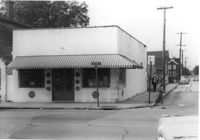
Building on site affected by the construction of the Crosstown. Address: 188 Spring Street. View of street corner. Surveyor notations on back of photo: "Dkt.: 10.524. Property owner: E.H. Heidman, Est. Tract: 18. Station: 24+ Lt. (Spring Street). Date: Oct. 13, 1964." [See collection description for explanation of surveyor notations.]
Right of way--South Carolina--Charleston County, Highway planning--South Carolina--Charleston County, Vernacular architecture--South Carolina--Charleston County, Lost architecture--South Carolina--Charleston County✖[remove]6