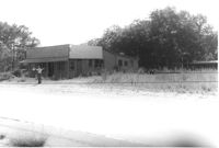
Lot and building on site affected by the widening of U.S. Route 17. Billboard for Busch Bavarian [beer] in background. Presumably located in Mount Pleasant or vicinity. Surveyor notations on back of photo: "Dkt.: 10.439. Property owner: A.J. Ashley. Tract: 19. Station: 241+92 Lt. Date: Jul. 22, 1965. Range poles on new R/W & man & range poles on pres. 33' R/W. Portion of bldg within R/W." [See collection description for explanation of surveyor notations.]
Lot and building on site affected by the widening of U.S. Route 17. Billboard for Busch Bavarian [beer] in background. Presumably located in Mount Pleasant or vicinity. Surveyor notations on back of photo: "Dkt.: 10.439. Property owner: A.J. Ashley. Tract: 19. Station: 241+92 Lt. Date: Jul. 22, 1965. Range poles on new R/W & man & range poles on pres. 33' R/W. Portion of bldg within R/W." [See collection description for explanation of surveyor notations.]
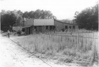
Lot and buildings on site affected by the widening of U.S. Route 17. Billboard for Busch Bavarian [beer] in background. Presumably located in Mount Pleasant or vicinity. Surveyor notations on back of photo: "Dkt.: 10.439. Property owner: A.J. Ashley. Tract: 19. Station: 238+85 to 242+45 Lt. Date: Jul. 22, 1965. Range poles on pres. & 75' R/W - Cond. 2 frame bldg." [See collection description for explanation of surveyor notations.]
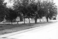
Lot and building on site affected by the widening of U.S. Route 17. Billboard for Busch Bavarian [beer] in background. Presumably located in Mount Pleasant or vicinity. Surveyor notations on back of photo: "Dkt.: 10.439. Property owner: Marie Basha. Tract: 22. Station: 245+45 to 246+45 Lt. Date: Jul. 22, 1965. Range poles on pres. & 50'R/W. Trees in R/W." [See collection description for explanation of surveyor notations.]
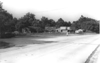
Lot with billboards for 1965 Corvair (Fort Sumter Chevrolet Co.) and Falstaff (beer), on site affected by the construction of the Crosstown. Address: 223 Spring Street. Surveyor notations on back of photo: "Dkt.: 10.524. Property owner: Turner Advertising Co. Tract: 159. Station: 16±80 Rt. Date: Dec. 2, 1964." [See collection description for explanation of surveyor notations.]
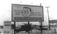
Billboard for BlueCross BlueShield on site affected by construction of the Crosstown. Billboard for Charleston Inn and 233 Spring Street (Shell gas station) in background. Presumably on Spring Street. Surveyor notations on back of photo: "Dkt.: 10.524. Property owner: Turner Advertising Co. Tract: 155. Station: 11±00 Rt. Spring Street. Date: Dec. 2, 1964." [See collection description for explanation of surveyor notations.]