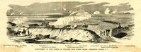
Caption: 'Bombardment of Fort Sumter, as sketched from Morris Island, Charleston Harbor, S.C.' Identified in image: Mortar Battery, Fort Johnson; James Island; City; Castle Pinckney; Fort Sumter; Mount Pleasant; Floating Battery; Mortar Battery; Fort Moultrie; Enfilading Battery; Iron Battery; Sand-bag cover for reserve; Traverse behind Trapier Battery and Magazine covered with sand bags.
[Color image.] Caption at top: 'The harbor of Charleston, S.C.--From sketches by our special artist.--Fort Moultrie, on Sullivan's Island.' Caption at middle: 'Fort Pinckney, Charleston, S.C.' Caption at bottom: 'Fort Sumter, Charleston, S.C.' [full date Dec. 1, 1860.]
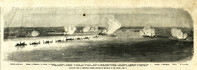
Caption: 'Panoramic view of Charleston Harbor--advance of iron-clads to the attack, April 7. Union--A. Keokuk. B. Nahunt. C. Nantucket. D. Catskill. E. Ironsides. F. Patapsco. G. Montauk. H. Passaie. K. Weehawken. Rebel--1. Morris Island sand battery. 2. Fort Wagner. 3. Battery Bee, on Cummings Point. 4. [Fort] Johnson. 5. Fort Ripley. 6. Sumter. 7. Charleston City. 8. Castle Pinckney. 9. Fort Redan. 10. Fort Moultrie. 11. Moultrie House. 12. Fort Beauregard. 13. Harbor obstructions. 14. Cooper River. 15. Ashley River.' [full date May 2, 1863.]
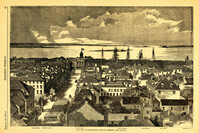
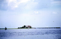
Caption: 'The city of Charleston, South Carolina.--[see page 62.]' Also identified in image: Broad Street, "Mercury" office, Custom-house, Castle Pinckney, Fort Moultrie, Fort Sumter and Morris Island. [full date January 26, 1861.]
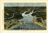
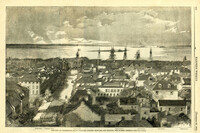
Caption: 'The city of Charleston, South Carolina, looking seaward, and showing the burned district.--[see next page.]' Identified in image are: Broad Street, "Mercury" office, Custom-house, Castle Pinckney, Fort Moultrie, Fort Sumter and Morris Island. [full date December 28, 1861.]