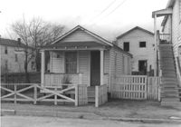
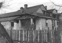
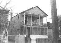
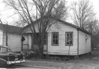
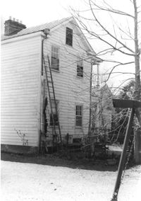
House on site affected by the construction of Interstate 26 (I-26). Address: 16 Lenox Street. Surveyor notations on back of photo: "Dkt.: 10.503. Property owner: Harry Thompson. Tract: 38. Station: 5901+50 Rt. Date: Feb. 19, 1963. In R/W - Bought." [See collection description for explanation of surveyor notations.]
House (rear view?) on site affected by the construction of Interstate 26 (I-26). Address: 16 Lenox Street. Surveyor notations on back of photo: "Dkt.: 10.503. Property owner: Harry Thompson. Tract: 38. Station: 5901+50 Rt. Date: Feb. 19, 1963. In R/W - Bought." [See collection description for explanation of surveyor notations.]
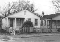
House on site affected by the construction of Interstate 26 (I-26). Address: 5 Lenox Street. Surveyor notations on back of photo: "Dkt.: 10.503. Property owner: Estelle Thompson. Tract: 40. Station: 5902+60 Lt. Date: Feb. 19, 1963. In R/W - Bought." [See collection description for explanation of surveyor notations.]
House (rear view) on site affected by the construction of Interstate 26 (I-26). Address: 5 Lenox Street. Surveyor notations on back of photo: "Dkt.: 10.503. Property owner: Estelle Thompson. Tract: 40. Station: 5902+60 Lt. Date: Feb. 19, 1963. In R/W - Bought." [See collection description for explanation of surveyor notations.]
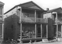
Houses on site affected by the construction of Interstate 26 (I-26). Address: 30 Brigade Street. Neighboring houses on either side also in photo. Written on border of photo: Men on projected R/W of Main Line (see plans). Surveyor notations on back of photo: "Dkt.: 10.503. Property owner: Gussie Feldman, et al. Tract: 41. Station: 5904+15 Rt. Date: Feb. 19, 1963. In R/W - Bought." [See collection description for explanation of surveyor notations.]
Houses (rear view) on site affected by the construction of Interstate 26 (I-26). Address: within the range of 20-32 Brigade Street. Surveyor notations on back of photo: "Dkt.: 10.503. Property owner: Gussie Feldman, et al. Tract: 41. Station: 5904+15 Rt. Date: Feb. 19, 1963. In R/W - Bought." [See collection description for explanation of surveyor notations.]
Houses on site affected by the construction of Interstate 26 (I-26). Address: within the range of 20-32 Brigade Street. Surveyor notations on back of photo: "Dkt.: 10.503. Property owner: Gussie Feldman, et al. Tract: 41. Station: 5904+15 Rt. Date: Feb. 19, 1963. In R/W - Bought." [See collection description for explanation of surveyor notations.]
Houses on site affected by the construction of Interstate 26 (I-26). Address: within the range of 20-32 Brigade Street. Surveyor notations on back of photo: "Dkt.: 10.503. Property owner: Gussie Feldman, et al. Tract: 41. Station: 5904+20 Rt. Date: Feb. 19, 1963. In R/W - Bought." [See collection description for explanation of surveyor notations.]
Houses on site affected by the construction of Interstate 26 (I-26). Address: 24 Brigade Street. Neighboring houses on either side also in photo. Surveyor notations on back of photo: "Dkt.: 10.503. Property owner: Gussie Feldman, et al. Tract: 41. Station: 5904+30 Lt. Date: Feb. 19, 1963. In R/W - Bought." [See collection description for explanation of surveyor notations.]
Houses on site affected by the construction of Interstate 26 (I-26). Address: within the range of 20-32 Brigade Street. Surveyor notations on back of photo: "Dkt.: 10.503. Property owner: Gussie Feldman. Tract: 41. Station: 5904+35 Lt. Date: Feb. 19, 1963. In R/W - Bought." [See collection description for explanation of surveyor notations.]
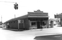
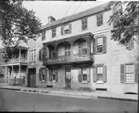
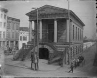
Building, on site affected by the construction of the Crosstown. Address: 626 King Street. Front facade has stepped parapet. View of street corner, with directional signage for Routes 78, 17, 52. Surveyor notations on back of photo: "Dkt.: 10.518. Property owner: Sands & Co. Tract: 16. Station: 9+50 Lt. Line Street (Line #2). Date: Mar. 6, 1963." [See collection description for explanation of surveyor notations.]
Houses on site affected by the construction of Interstate 26 (I-26). Address: within the range of 20-32 Brigade Street. Handwritten on border of photo: Men on projected R/W of main line (see plans). Surveyor notations on back of photo: "Dkt.: 10.503. Property owner: Gussie Feldman. Tract: 41. Station: 5904+35 Lt. Date: Feb. 19, 1963. In R/W - Bought." [See collection description for explanation of surveyor notations.]
Houses and neighboring shed/garage on site affected by the construction of Interstate 26 (I-26). Address: within the range of 20-32 Brigade Street. Surveyor notations on back of photo: "Dkt.: 10.503. Property owner: Gussie Feldman. Tract: 41. Station: 5904+35 Lt. Date: Feb. 19, 1963. In R/W - Bought." [See collection description for explanation of surveyor notations.]
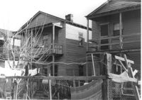
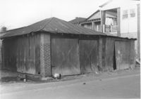
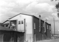
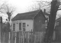
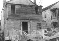
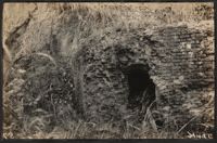
Shed or garage on site affected by the construction of Interstate 26 (I-26). Address: within the range of 20-32 Brigade Street. Surveyor notations on back of photo: "Dkt.: 10.503. Property owner: Gussie Feldman, et al.. Tract: 41. Station: 5903+92 Lt. (in Brigade St. R/W). Date: Feb. 19, 1963. In R/W - Bought." [See collection description for explanation of surveyor notations.]
Structure (shed?) on site affected by the construction of Interstate 26 (I-26). Address: within the range of 20-32 Brigade Street. Surveyor notations on back of photo: "Dkt.: 10.503. Property owner: Gussie Feldman. Tract: 41. Station: 5903+92 Lt. Date: Feb. 19, 1963. In R/W - Bought." [See collection description for explanation of surveyor notations.]
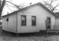
House on site affected by the construction of Interstate 26 (I-26). Address: 1085 Meeting Street. Surveyor notations on back of photo: "Dkt.: 10.503. Property owner: Gussie Feldman. Tract: 41. Station: 5903+50 Lt. (In Brigade Street R/W.) Date: Feb. 19, 1963. In R/W - Bought." [See collection description for explanation of surveyor notations.]
House (rear view) on site affected by the construction of Interstate 26 (I-26). Address: 1085 Meeting Street. Surveyor notations on back of photo: "Dkt.: 10.503. Property owner: Gussie Feldman. Tract: 41. Station: 5903+50 Lt. Date: Feb. 19, 1963. In R/W - Bought." [See collection description for explanation of surveyor notations.]
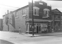
Laundromat / Half Hour Laundry on site affected by the construction of Interstate 26 (I-26). Address: 1085 Meeting Street. View of street corner. Surveyor notations on back of photo: "Dkt.: 10.503. Property owner: Gussie Feldman. Tract: 41. Station: 5903+50 Lt. Date: Feb. 19, 1963. In R/W - Bought." [See collection description for explanation of surveyor notations.]
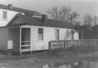
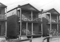
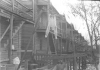
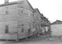
Row of houses (rear view) on site affected by the construction of Interstate 26 (I-26). Address: 20-32 Brigade Street. Surveyor notations on back of photo: "Dkt.: 10.503. Property owner: Gussie Feldman. Tract: 41. Station: 5904±20 Rt. & Lt. Date: Feb. 19, 1963. In R/W - Bought. (Rear of buildings fronting Brigade Street.)" [See collection description for explanation of surveyor notations.]
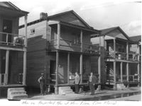
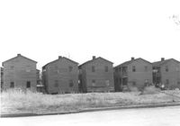
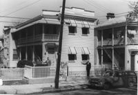
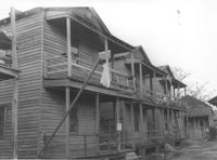
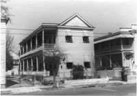
Row of houses on Brigade Street, on site affected by the construction of Interstate 26 (I-26). Address: 10-18 J Place [between Lenox and Brigade]. (See Sheet 1 of 1951 Sanborn Map.) Surveyor notations on back of photo: "Dkt.: 10.503. Property owner: Gussie Feldman. Tract: 41. Station: 5903+50 Rt. & Lt. In R/W - Bought." [See collection description for explanation of surveyor notations.]
Row of houses (rear view) on site affected by the construction of Interstate 26 (I-26). Address: 16-18 J Place [between Lenox and Brigade]. (See Sheet 1 of 1951 Sanborn Map.) Surveyor notations on back of photo: "Dkt.: 10.503. Property owner: Gussie Feldman. Tract: 41. Station: 5903+50 Rt. & Lt. In R/W - Bought." [See collection description for explanation of surveyor notations.]
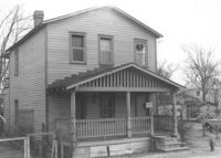
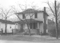
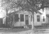
House on site affected by the construction of the Crosstown. Address: 94 Sheppard Street. Surveyor notations on back of photo: "Dkt.: 10.518. Property owner: Alice Davis. Tract: 17. Station: 30+55 Lt. Sheppard Street. Date: Mar. 6, 1963. Proximity. [See collection description for explanation of surveyor notations.]
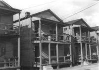
Row of houses on site affected by the construction of Interstate 26 (I-26). Address: 10-14 J Place [between Lenox and Brigade]. (See Sheet 1 of 1951 Sanborn Map.) Surveyor notations on back of photo: "Dkt.: 10.503. Property owner: Gussie Feldman. Tract: 41. Station: 5903+50 Rt. & Lt. In R/W - Bought." [See collection description for explanation of surveyor notations.]
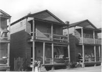
Row of houses on site affected by the construction of Interstate 26 (I-26). Address: 20-32 Brigade Street. Surveyor notations on back of photo: "Dkt.: 10.503. Property owner: Gussie Feldman. Tract: 41. Station: 5904+30 Rt. In R/W - Bought." [See collection description for explanation of surveyor notations.]
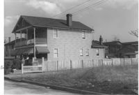
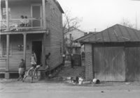
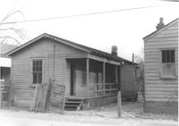
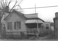
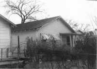
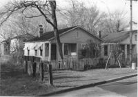
House on site affected by the construction of Interstate 26 (I-26). Address: 11 Brigade Street. Surveyor notations on back of photo: "Dkt.: 10.503. Property owner: Ada Williams. Tract: 42. Station: 5905+20 Rt. Date: Feb. 19, 1963. In R/W - Bought." [See collection description for explanation of surveyor notations.]
House on site affected by the construction of Interstate 26 (I-26). Address: 11 Brigade Street. Surveyor notations on back of photo: "Dkt.: 10.503. Property owner: Ada Williams. Tract: 42. Station: 5905+20 Rt. Date: Feb. 19, 1963. In R/W - Bought." [See collection description for explanation of surveyor notations.]
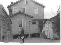
House (freedman's cottage?) on site affected by the construction of Interstate 26 (I-26). Address: 10 Brigade Street. Surveyor notations on back of photo: "Dkt.: 10.503. Property owner: Nathan Williams. Tract: 43. Station: 5905+30 Rt. Date: Feb. 19, 1963. In R/W - Bought." [See collection description for explanation of surveyor notations.]
House (rear view) on site affected by the construction of Interstate 26 (I-26). Address: 10 Brigard Street. Surveyor notations on back of photo: "Dkt.: 10.503. Property owner: Nathan Williams. Tract: 43. Station: 5905+30 Rt. Date: Feb. 19, 1963. In R/W - Bought." [See collection description for explanation of surveyor notations.]
Dwelling or outbuilding on site affected by the construction of Interstate 26 (I-26). Address: 9 Brigade Street. Surveyor notations on back of photo: "Dkt.: 10.503. Property owner: Gussie Feldman, et al. Tract: 44. Station: 5905+30 Rt. Date: Feb. 19, 1963. In R/W - Bought." [See collection description for explanation of surveyor notations.]
House (freedman's cottage) on site affected by the construction of Interstate 26 (I-26). Address: 9 Brigade Street. Surveyor notations on back of photo: "Dkt.: 10.503. Property owner: Gussie Feldman, et al. Tract: 44. Station: 5905+30 Rt. Date: Feb. 19, 1963. In R/W - Bought." [See collection description for explanation of surveyor notations.]
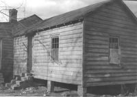
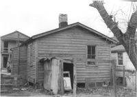
House (freedman's cottage) on site affected by the construction of Interstate 26 (I-26). Address: 8 Brigade Street. Surveyor notations on back of photo: "Dkt.: 10.503. Property owner: Gussie Feldman, et al. Tract: 44-A. Station: 5905+00 Rt. & Lt. Date: Feb. 19, 1963. In R/W - Bought." [See collection description for explanation of surveyor notations.]
House (freedman's cottage) (rear view) on site affected by the construction of Interstate 26 (I-26). Address: 8 Brigade Street. Surveyor notations on back of photo: "Dkt.: 10.503. Property owner: Gussie Feldman, et al. Tract: 44-A. Station: 5905+00 Rt. & Lt. Date: Feb. 19, 1963. In R/W - Bought." [See collection description for explanation of surveyor notations.]
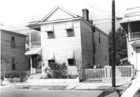
House on site affected by the construction of the Crosstown. Address: 96 Sheppard Street. Surveyor notations on back of photo: "Dkt.: 10.518. Property owner: Celia McFadden. Tract: 18. Station: 30+10 Lt. Sheppard Street. Date: Mar. 6, 1963. In R/W - Bought. [See collection description for explanation of surveyor notations.]
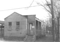
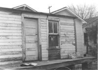
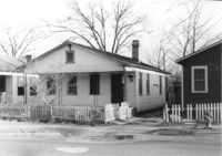
House on site affected by the construction of Interstate 26 (I-26). Address: 7 Brigade Street. Surveyor notations on back of photo: "Dkt.: 10.503. Property owner: Idella C. Calvin. Tract: 45. Station: 5905+20 Lt. Date. Date: Feb. 19, 1963. In R/W - Bought." [See collection description for explanation of surveyor notations.]
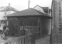
Small dwelling on site affected by the construction of Interstate 26 (I-26). Address: 7 Brigade Street. Surveyor notations on back of photo: "Dkt.: 10.503. Property owner: Idella C. Calvin. Tract: 45. Station: 5905+50 Lt. Date. Date: Feb. 19, 1963. In R/W - Bought." [See collection description for explanation of surveyor notations.]
House (freedman's cottage) on site affected by the construction of Interstate 26 (I-26). Address: 7 Brigade Street. Surveyor notations on back of photo: "Dkt.: 10.503. Property owner: Idella C. Calvin. Tract: 45. Station: 5905+20 Lt. Date: Feb. 19, 1963. In R/W - Bought." [See collection description for explanation of surveyor notations.]
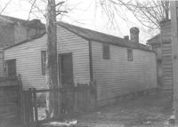
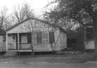
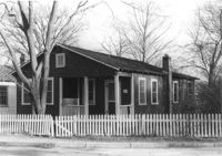
House on site affected by the construction of Interstate 26 (I-26). Address: 5 Brigade Street. Surveyor notations on back of photo: "Dkt.: 10.503. Property owner: Maybelle Taylor. Tract: 46. Station: 5905+00 Lt. Date: Feb. 19, 1963. In R/W - Bought." [See collection description for explanation of surveyor notations.]
House (rear view) on site affected by the construction of Interstate 26 (I-26). Address: 5 Brigade Street. Surveyor notations on back of photo: "Dkt.: 10.503. Property owner: Maybelle Taylor. Tract: 46. Station: 5905+00 Lt. Date: Feb. 19, 1963. In R/W - Bought." [See collection description for explanation of surveyor notations.]
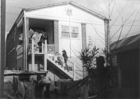
House on site affected by the construction of Interstate 26 (I-26). Address: 2 Maple Street. Surveyor notations on back of photo: "Dkt.: 10.503. Property owner: Ida Breibart. Tract: 47. Station: 5906+05 Lt. Date: Feb. 19, 1963. In R/W - Bought." [See collection description for explanation of surveyor notations.]
House (rear view) on site affected by the construction of Interstate 26 (I-26). Address: 2 Maple Street. Surveyor notations on back of photo: "Dkt.: 10.503. Property owner: Ida Breibart. Tract: 47. Station: 5906+05 Lt. Date: Feb. 19, 1963. In R/W - Bought." [See collection description for explanation of surveyor notations.]
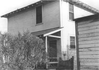
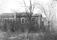
Structure on site affected by the construction of Interstate 26 (I-26). Address: 4 Maple Street. Surveyor notations on back of photo: "Dkt.: 10.503. Property owner: Frank Donnelly, et al. Tract: 48. Station: 5906+10 Lt. Date: Feb. 19, 1963. In R/W - Bought." [See collection description for explanation of surveyor notations.]
House on site affected by the construction of Interstate 26 (I-26). Address: 4 Maple Street. Surveyor notations on back of photo: "Dkt.: 10.503. Property owner: Frank Donnelly, et al. Tract: 48. Station: 5906+10 Lt. Date: Feb. 19, 1963. In R/W - Bought." [See collection description for explanation of surveyor notations.]
House on site affected by the construction of Interstate 26 (I-26). Address: 6 Maple Street. Surveyor notations on back of photo: "Dkt.: 10.503. Property owner: Atlantic Coast Life Ins. Co., et al. Tract: 49. Station: 5906+25 Lt. on CL. Date: Feb. 19, 1963. In R/W - Bought." [See collection description for explanation of surveyor notations.]
House on site affected by the construction of the Crosstown. Address: 96 Sheppard Street. Surveyor notations on back of photo: "Dkt.: 10.518. Property owner: Celia McFadden. Tract: 18. Station: 30+10 Lt. Sheppard Street. Date: Mar. 6, 1963. In R/W - Bought. [See collection description for explanation of surveyor notations.]
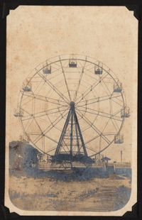
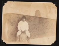
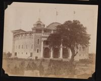
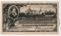
Ticket from Wagener Day, May 22, 1902. (Front Side) This day was named for Captain F.W. Wagener, President of the Exposition Company and the donor of the land used for the Exposition. The highest attendance figures of the fair were recorded that day.;Photo from the South Carolina Inter-State and West Indian Exposition
Portion of house (rear view) on site affected by the construction of Interstate 26 (I-26). Address: 6 Maple Street. Surveyor notations on back of photo: "Dkt.: 10.503. Property owner: Atlantic Coast Life Ins. Co., et al. Tract: 49. Station: 5906+25 Lt. on CL. Date: Feb. 19, 1963. In R/W - Bought." [See collection description for explanation of surveyor notations.]
House (rear view) on site affected by the construction of Interstate 26 (I-26). Address: 8 Maple Street. Surveyor notations on back of photo: "Dkt.: 10.503. Property owner: Atlantic Coast Life Ins. Co., et al. Tract: 50. Station: 5906+30 Rt. Date: Feb. 19, 1963. In R/W - Bought." [See collection description for explanation of surveyor notations.]
House on site affected by the construction of Interstate 26 (I-26).Address: 8 Maple Street. Surveyor notations on back of photo: "Dkt.: 10.503. Property owner: Atlantic Coast Life Ins. Co., et al. Tract: 50. Station: 5906+30 Rt. Date: Feb. 19, 1963. In R/W - Bought." [See collection description for explanation of surveyor notations.]
House on site affected by the construction of Interstate 26 (I-26). Address: 10 Maple Street. Surveyor notations on back of photo: "Dkt.: 10.503. Property owner: Gertrude C. Tindall, Est. Tract: 51. Station: 5906+40 Rt. Date: Feb. 19, 1963. In R/W - Bought." [See collection description for explanation of surveyor notations.]
House (rear view) on site affected by the construction of Interstate 26 (I-26). Address: 10 Maple Street. Surveyor notations on back of photo: "Dkt.: 10.503. Property owner: Gertrude C. Tindall, Est. Tract: 51. Station: 5906+40 Rt. Date: Feb. 19, 1963. In R/W - Bought." [See collection description for explanation of surveyor notations.]
House (rear view) on site affected by the construction of Interstate 26 (I-26). Address: 12 Maple Street. Surveyor notations on back of photo: "Dkt.: 10.503. Property owner: Atlantic Coast Life Ins. Co., et al. Tract: 52. Station: 5906+45 Rt. Date: Feb. 19, 1963. In R/W - Bought." [See collection description for explanation of surveyor notations.]
House on site affected by the construction of Interstate 26 (I-26). Address: 12 Maple Street. Surveyor notations on back of photo: "Dkt.: 10.503. Property owner: Atlantic Coast Life Ins. Co., et al. Tract: 52. Station: 5906+45 Rt. Date: Feb. 19, 1963. In R/W - Bought." [See collection description for explanation of surveyor notations.]
House on site affected by the construction of Interstate 26 (I-26). Address: 13 Maple Street. Surveyor notations on back of photo: "Dkt.: 10.503. Property owner: Aliene Cox Tindall. Tract: 53. Station: 5907+65 Rt. Date: Feb. 19, 1963. In R/W - Bought." [See collection description for explanation of surveyor notations.]
House (rear view) on site affected by the construction of Interstate 26 (I-26). Address: 13 Maple Street. Surveyor notations on back of photo: "Dkt.: 10.503. Property owner: Aliene Cox Tindall. Tract: 53. Station: 5907+65 Rt. Date: Feb. 19, 1963. In R/W - Bought." [See collection description for explanation of surveyor notations.]
House on site affected by the construction of Interstate 26 (I-26). Address: 11 Maple Street. Surveyor notations on back of photo: "Dkt.: 10.503. Property owner: James L. Tyler. Tract: 54. Station: 5907+50 Rt. Date: Feb. 19, 1963. In R/W - Bought." [See collection description for explanation of surveyor notations.]
House on site affected by the construction of the Crosstown. Address: 96 Sheppard Street. Surveyor notations on back of photo: "Dkt.: 10.518. Property owner: Celia McFadden. Tract: 18. Station: 30+10 Lt. Sheppard Street. Date: Mar. 6, 1963. In R/W - Bought. [See collection description for explanation of surveyor notations.]