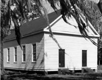
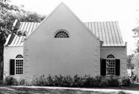
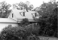
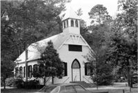
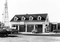
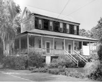
Appleby Methodist Church, Wire Road - intersection of County Roads 19 & 71. View of Front and Side elevation. Reevesville, S.C.;8" x 10" B/W photo. Box 17, Folder 3-3-3. One copy.
How Tavern, ca. 1744. View of North (Front) elevation. Cainhoy (Huger vicinity, Lewisville, Louisville), S.C.;8" x 10" B/W photo. Box 4, Folder 1-12-3. One copy.
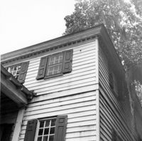
Dr. Morton Waring House - Main House. View of South (Rear) elevation, looking East. Pinopolis Historic District South. Pinopolis, S.C.;6.5" x 9.5" B/W photo. Box 4, Folder 1-10-1 (III). Two copies.
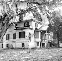
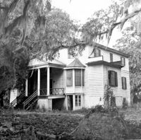
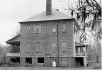
Dr. Morton Waring House - Main House. View of NW (Front and Side) elevation. Pinopolis Historic District South. Pinopolis, S.C.;6.5" x 9.5" B/W photo. Box 4, Folder 1-10-1 (III). Two copies.
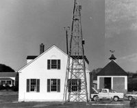
Folly Island Staging Area (Battery Green, U.S. Coast Guard Loran Station, Folly North Site), Address restricted. View facing WNW. Folly Beach, S.C.;8" x 10" B/W photo. Box 17, Folder 2-16-1. One copy.
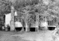
William Cain House - Main House. Detail View of Rear Door and Windows, South (Rear) elevation, looking East. Pinopolis Historic District North. Pinopolis, S.C.;6.5" x 9.5" B/W photo. Box 4, Folder 1-10-1 (III). Two copies.
St. Andrews Episcopal Church (Old St. Andrews Parish Church), 2604 Ashley River Road. View of West (Rear) elevation. Charleston, S.C.;6.5" x 10" B/W photo. Box 14, Folder 2-9-7. One copy.
St. Andrews Episcopal Church (Old St. Andrews Parish Church), 2604 Ashley River Road. View of East (Front) elevation. Charleston, S.C.;10" x 8" B/W photo. Box 14, Folder 2-9-7. One copy.
St. Andrews Episcopal Church (Old St. Andrews Parish Church), 2604 Ashley River Road. Interior View - North Entrance. North elevation. Charleston, S.C.;10" x 6.5" B/W photo. Box 14, Folder 2-9-7. One copy.
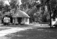
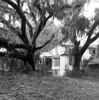
William Robertson House - Office (Wampee Plantation Summer House). View of SW (Front and Side) elevation. Pinopolis, S.C.;9.5" x 6.5" B/W photo. Box 4, Folder 1-10-1 (III). Two copies.
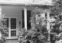
Dr. Morton Waring House - Lodge. Detail View of Front Porch, East (Front) elevation. Pinopolis Historic District South. Pinopolis, S.C.;6.5" x 9.5" B/W photo. Box 4, Folder 1-10-1 (III). Two copies.
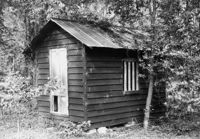
Dr. Morton Waring House - Outbuilding. View of NE (Side and Front) elevation. Pinopolis Historic District South. Pinopolis, S.C.;6.5" x 9.5" B/W photo. Box 4, Folder 1-10-1 (III). Two copies.
Dr. Morton Waring House - Office. View of SE (Front and Side) elevation. Pinopolis Historic District South. Pinopolis, S.C.;6.5" x 9.5" B/W photo. Box 4, Folder 1-10-1 (III). Two copies.
Dr. Morton Waring House - Lodge. View of NW (Side and Rear) elevation. Pinopolis Historic District South. Pinopolis, S.C.;6.5" x 9.5" B/W photo. Box 4, Folder 1-10-1 (III). Two copies.
Dr. Morton Waring House - Lodge. View of East (Front) elevation. Pinopolis Historic District South. Pinopolis, S.C.;6.5" x 9.5" B/W photo. Box 4, Folder 1-10-1 (III). Two copies.
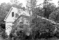
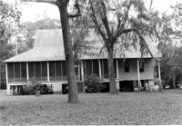
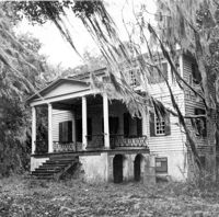
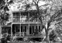
Isaac Porcher House - Main House. View of North (Front) elevation. Pinopolis Historic District North. Pinopolis, S.C.;6.5" x 9.5" B/W photo. Box 4, Folder 1-10-1 (III). Two copies.
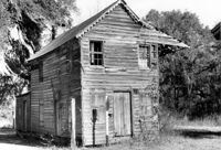
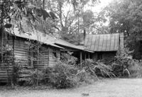
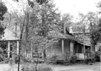
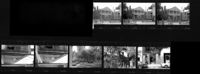
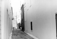
Old Carroll House (Carroll Place), Junction of Quaker and Wire Roads. Contact Sheet 13 - Multiple Views. St. George, S.C.;10" x 4" B/W photo. Box 20, Folder: Miscellaneous Photos: Scanned Contact Sheets. One copy.
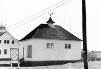
U.S. Coast Guard Historical District, I'on Avenue. Garage - View of South (Side) elevation. Sullivans Island, S.C.;6.5" x 10" (and 3.5" x 5") B/W photo. Box 16, Folder 2-13-1. Two copies.
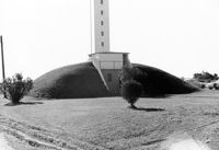
U.S. Coast Guard Historical District, I'on Avenue. Bunker - View of South (Rear) elevation. Sullivans Island, S.C.;6.5" x 10" (and 3.5" x 5") B/W photo. Box 16, Folder 2-13-1. Two copies.
U.S. Coast Guard Historical District, I'on Avenue. Garage - View of NE (Side and Rear) elevation. Sullivans Island, S.C.;6.5" x 10" (and 3.5" x 5") B/W photo. Box 16, Folder 2-13-1. Two copies.
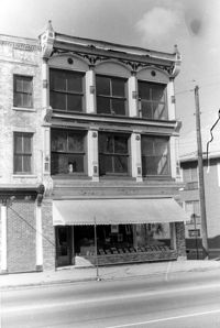
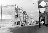
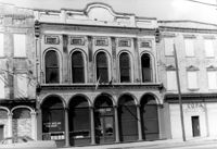
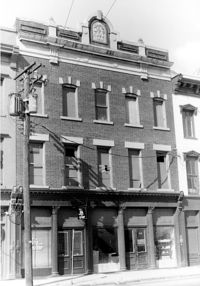
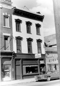
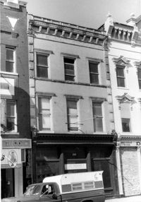
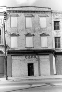
Cast Iron District, 207-235 Meeting Street - Detail of 211. View of NW (Front) elevation, looking North. Charleston, S.C.;10" x 6.5" B/W photo. Box 9, Folder 2-1-159. Three copies.
U.S. Coast Guard Historical District, I'on Avenue. Administration Building - View of SW (Side and Rear) elevation. Sullivans Island, S.C.;6.5" x 10" (and 3.5" x 5") B/W photo. Box 16, Folder 2-13-1. Two copies.
U.S. Coast Guard Historical District, I'on Avenue. Administration Building - View of East (Side) elevation. Sullivans Island, S.C.;6.5" x 10" (and 3.5" x 5") B/W photo. Box 16, Folder 2-13-1. Two copies.
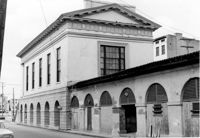
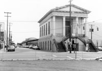
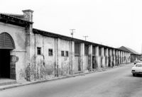
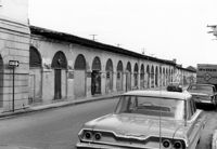
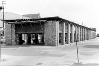
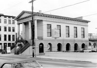
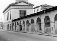
City Market - Market Hall and Third Section of Sheds. View of SW (Front and Side) elevation. Charleston, S.C.;6.5" x 10" B/W photo. Box 6, Folder 2-1-14. One copy.
City Market - Market Hall and Second Section of Sheds. View of SW (Front and Side) elevation. Charleston, S.C.;6.5" x 10" B/W photo. Box 6, Folder 2-1-14. One copy.
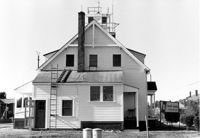
U.S. Coast Guard Historical District, I'on Avenue. Administration Building - View of South (Rear) elevation. Sullivans Island, S.C.;6.5" x 10" (and 3.5" x 5") B/W photo. Box 16, Folder 2-13-1. Two copies.
U.S. Coast Guard Historical District, I'on Avenue. Garage - View of East (Front) elevation. Sullivans Island, S.C.;6.5" x 10" (and 3.5" x 5") B/W photo. Box 16, Folder 2-13-1. Two copies.
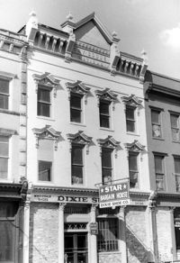
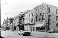
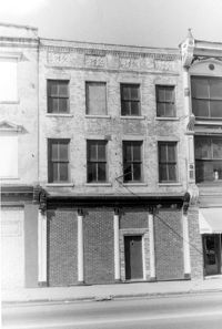
Cast Iron District, 207-235 Meeting Street - Detail of 235. View of NW (Front) elevation, looking North. Charleston, S.C.;10" x 6.5" B/W photo. Box 9, Folder 2-1-159. Three copies.
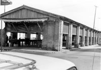
City Market - Market Hall and First Section of Sheds. View of South (Side) elevation, looking East. Charleston, S.C.;6.5" x 10" B/W photo. Box 6, Folder 2-1-14. One copy.
City Market - Market Hall and First Section of Sheds. View of South (Side) elevation, looking East. Charleston, S.C.;6.5" x 10" B/W photo. Box 6, Folder 2-1-14. One copy.
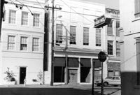
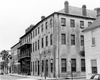
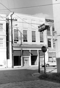
McCrady's Tavern and Long Room, 153 East Bay Street. View of SW (Side and Front) elevation. Charleston, S.C.;6.5" x 10" B/W photo. Box 6, Folder 2-1-31. One copy.
City Market - Market Hall and Fourth Section of Sheds. View of SW (Front and Side) elevation. Charleston, S.C.;6.5" x 10" B/W photo. Box 6, Folder 2-1-14. One copy.
U.S. Coast Guard Historical District, I'on Avenue. Bunker - View of NW (Side and Front) elevation. Sullivans Island, S.C.;6.5" x 10" (and 3.5" x 5") B/W photo. Box 16, Folder 2-13-1. Two copies.
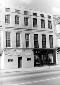
Cast Iron District, 207-235 Meeting Street - Detail of 213. View of NW (Front) elevation, looking North. Charleston, S.C.;10" x 6.5" B/W photo. Box 9, Folder 2-1-159. Three copies.
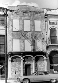
Cast Iron District, 207-235 Meeting Street - Detail of 207. View of NW (Front and Side) elevation. Charleston, S.C.;10" x 6.5" B/W photo. Box 9, Folder 2-1-159. Three copies.
Cast Iron District, 207-235 Meeting Street - Detail of 223. View of NW (Front) elevation, looking North. Charleston, S.C.;10" x 6.5" B/W photo. Box 9, Folder 2-1-159. Three copies.
Cast Iron District, 207-235 Meeting Street - Detail of 227. View of NW (Front) elevation, looking North. Charleston, S.C.;10" x 6.5" B/W photo. Box 9, Folder 2-1-159. Three copies.
Cast Iron District, 207-235 Meeting Street - Detail of 229. View of NW (Front) elevation, looking North. Charleston, S.C.;6.5" x 10" B/W photo. Box 9, Folder 2-1-159. Three copies.
Cast Iron District, 207-235 Meeting Street - Detail of 233. View of NW (Front) elevation, looking North. Charleston, S.C.;10" x 6.5" B/W photo. Box 9, Folder 2-1-159. Three copies.
McCrady's Tavern and Long Room, 153 East Bay Street. View of South (Front) elevation (looking West from East Bay Street). Charleston, S.C.;10" x 6.5" B/W photo. Box 6, Folder 2-1-31. One copy.
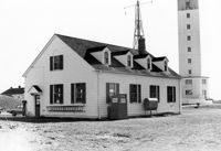
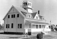
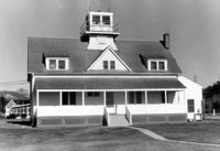
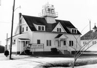
U.S. Coast Guard Historical District, I'on Avenue. Administration Building - View of North (Front) elevation. Sullivans Island, S.C.;6.5" x 10" (and 3.5" x 5") B/W photo. Box 16, Folder 2-13-1. Two copies.
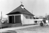
U.S. Coast Guard Historical District, I'on Avenue. Boat House - View of NW (Side and Front) elevation. Sullivans Island, S.C.;6.5" x 10" (and 3.5" x 5") B/W photo. Box 16, Folder 2-13-1. Two copies.
U.S. Coast Guard Historical District, I'on Avenue. Boat House - View of SE (Side and Rear) elevation. Sullivans Island, S.C.;6.5" x 10" (and 3.5" x 5") B/W photo. Box 16, Folder 2-13-1. Two copies.
U.S. Coast Guard Historical District, I'on Avenue. Bunker - View of North (Front) elevation. Sullivans Island, S.C.;6.5" x 10" (and 3.5" x 5") B/W photo. Box 16, Folder 2-13-1. Two copies.
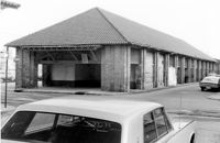
City Market - Market Hall and First Section of Sheds. View of SE (Side and Rear) elevation. Charleston, S.C.;8" x 10" B/W photo. Box 6, Folder 2-1-14. One copy.
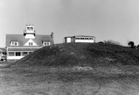
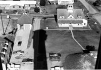
U.S. Coast Guard Historical District, I'on Avenue. Aerial View - South elevation. Sullivans Island, S.C.;6.5" x 10" (and 3.5" x 5") B/W photo. Box 16, Folder 2-13-1. Two copies.
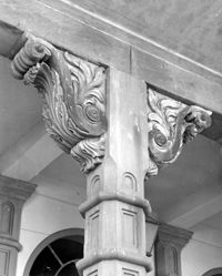
Dock Street Theater, 135 Church Street. Detail View of Porch Column. West (Front) elevation. Charleston, S.C.;10" x 8" B/W photo. Box 6, Folder 2-1-32. One copy.
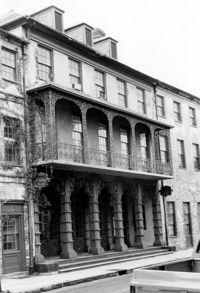
Dock Street Theater, 135 Church Street. View of NW (Front) elevation, looking West. Charleston, S.C.;10" x 6.5" B/W photo. Box 6, Folder 2-1-32. One copy.
Dock Street Theater, 135 Church Street. View of NW (Front) elevation, looking West. Charleston, S.C.;6.5" x 10" B/W photo. Box 6, Folder 2-1-32. One copy.
Cast Iron District, 207-235 Meeting Street - Detail of 215. View of NW (Front) elevation, looking North. Charleston, S.C.;10" x 6.5" B/W photo. Box 9, Folder 2-1-159. Three copies.
Cast Iron District, 207-235 Meeting Street - Detail of 217. View of NW (Front) elevation, looking North. Charleston, S.C.;10" x 6.5" B/W photo. Box 9, Folder 2-1-159. Three copies.
Cast Iron District, 207-235 Meeting Street - Detail of 209. View of NW (Front) elevation, looking North. Charleston, S.C.;10" x 6.5" B/W photo. Box 9, Folder 2-1-159. Three copies.
Cast Iron District, 207-235 Meeting Street - Detail of 231. View of NW (Front) elevation, looking North. Charleston, S.C.;10" x 6.5" B/W photo. Box 9, Folder 2-1-159. Three copies.
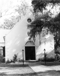
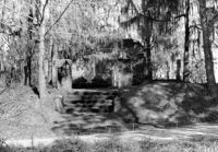
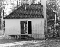
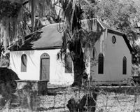
White Church (St. Thomas Church, The Brick Church), Off of Cainhoy Road. Vestry - View of Side elevation. Cainhoy, S.C.;8" x 10" B/W photo. Box 4, Folder 1-12-2. One copy.
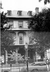
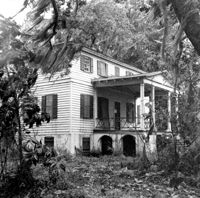
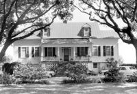
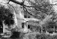
Rockville Historic District - Cornelia J. Whaley House, Grace Chapel Road. View of South (Front) elevation. Wadmalaw Island, S.C.;8" x 6.5" (and 6.5" x 10") B/W photo. Box 17, Folder 2-14-19. Three copies.
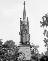
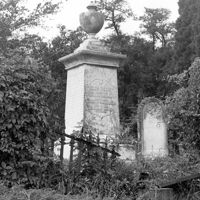
Magnolia Cemetery, Huguenin Avenue and Algonquin Road. Monument of Sarah F., Charles F., and Elbert P. Jones. View of East elevation. Charleston, S.C.;10" x 8" B/W photo. Box 5, Folder 2-1-3. One copy.
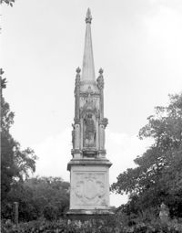
Magnolia Cemetery, Huguenin Avenue and Algonquin Road. Monument of Sarah F., Charles F., and Elbert P. Jones. View of West elevation. Charleston, S.C.;10" x 8" B/W photo. Box 5, Folder 2-1-3. One copy.
Magnolia Cemetery, Huguenin Avenue and Algonquin Road. Tombstone of Thomas Bennett. View of Front and Side elevation. Charleston, S.C.;8" x 8" B/W photo. Box 5, Folder 2-1-3. One copy.
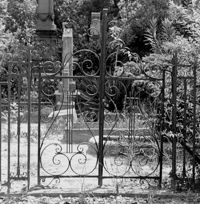
Magnolia Cemetery, Huguenin Avenue and Algonquin Road. Trapier-Jervey Gate. View of Front elevation. Charleston, S.C.;8" x 8" B/W photo. Box 5, Folder 2-1-3. One copy.
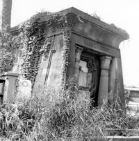
Magnolia Cemetery, Huguenin Avenue and Algonquin Road. Vanderhorst Mausoleum. View of Front and Side elevation. Charleston, S.C.;8" x 8" B/W photo. Box 5, Folder 2-1-3. One copy.
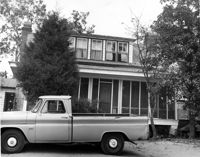
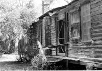
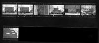
Ralph Ingle House (Simonds House), 1009 Middle Street. Contact Sheet 15 - Multiple views of exterior and interior. Sullivans Island, S.C.;10" x 3.5" B/W photo. Box 20, Folder: Miscellaneous Photos: Scanned Contact Sheets. One copy.
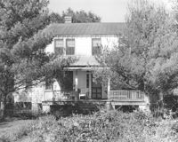
Rockville Historic District - Cornelia J. Whaley House, Grace Chapel Road. View of SW (Front and Side) elevation. Wadmalaw Island, S.C.;6.5" x 10" B/W photo. Box 17, Folder 2-14-19. Two copies.
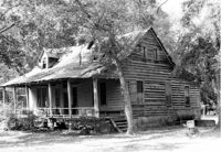
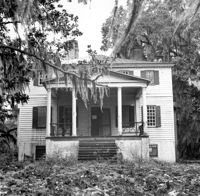
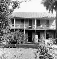
Rockville Historic District - W.E. Jenkins House (James LaRoche House). View of South (Front) elevation. Wadmalaw Island, S.C.;6.5" x 10" B/W photo. Box 17, Folder 2-14-15. One copy.