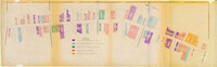
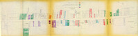
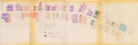
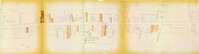
One of four maps of King Street building footprints, hand-colored to designate status. This map illustrates the historical significance of buildings on King Street from Calhoun Street to Queen Street.
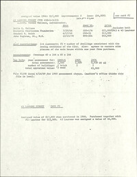
In this one-page typed bulletin, Green discusses the ownership and occupancy histories of 42 Anson Street; 44 Anson Street; 46 Anson Street; 48 Anson Street; and 50 Anson Street. Also focuses on Martin Dowd's properties in Charleston, including 53 Tradd Street.
One of four maps of King Street building footprints, hand-colored to designate status. This map illustrates the historical significance of buildings on King Street from Calhoun Street to Columbus Street.
In this one-page typed document eight houses and gardens are added to the walking tour through the Ansonborough Neighborhood: 19 Wentworth Street, 57 Anson Street, 46 Society Street,43 Society Street, 63 Anson Street, 75 Anson Street, and 79 Anson Street. An approximate date of when the buildings on the property were built, as well as ownership information, is included.
One of four maps of King Street building footprints, hand-colored to designate status. This map illustrates proposed reuses of buildings on King Street from Calhoun Street to Queen Street.
One of four maps of King Street building footprints, hand-colored to designate status. This map illustrates area conditions of buildings on King Street from Calhoun Street to Columbus Street.
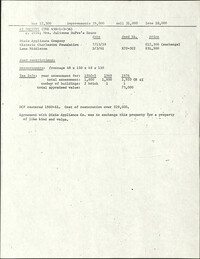
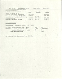
This one-page typed document, is a compilation of notes from an investigation into the ownership history of the property at 45 Hasell Street, tracing the property deed back to 1837.
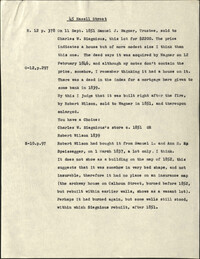
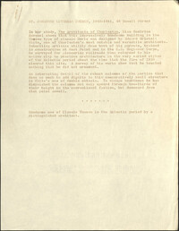
This one-page typed document discusses the historical background and describes the architecture of the building at 48 Hasell Street, St. Johannes Lutheran Church. The unknown writer references Beatrice Ravenel's book, The Architects of Charleston.