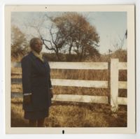
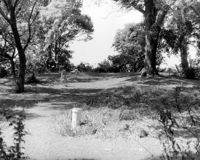
Color photograph of Septima P. Clark standing by a fence. Inscribed on back: "Septima Clark. Author of "Echo in My Soul" friend who showed me John's Island, S.C. Dec 7, 1971. Standing in fringe of home where land where she boarded is–now abandoned but owned–"
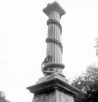
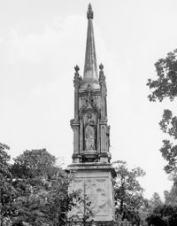
Magnolia Cemetery, Huguenin Avenue and Algonquin Road. Monument of Colonel William Washington. Detail View of column. South elevation. Charleston, S.C.;8" x 8" B/W photo. Box 5, Folder 2-1-3. Three copies.
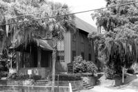
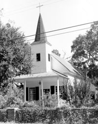
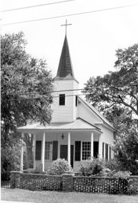
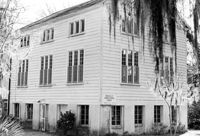
St. Andrews Episcopal Church (Mount Pleasant), 440 Whilden Street. View of SE (Front and Side) elevation. Mount Pleasant, S.C.;6.5" x 10" B/W photo. Box 13, Folder 2-8-18. One copy.
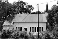
St. Andrews Episcopal Church (Mount Pleasant), 440 Whilden Street. View of East (Side) elevation. Mount Pleasant, S.C.;6.5" x 10" B/W photo. Box 13, Folder 2-8-18. Three copies.
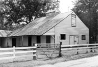
Boone Hall Plantation, Oak Avenue. Old Commissary - View of SW (Front and Side) elevation. Mount Pleasant, S.C.;6.5" x 10" B/W photo. Box 10, Folder 2-2-5. One copy.
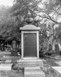
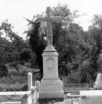
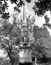
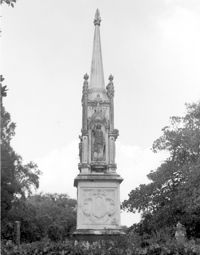
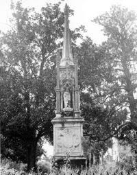
Magnolia Cemetery, Huguenin Avenue and Algonquin Road. Monument of William Ashmead Courtenay. View of Front elevation. Charleston, S.C.;10" x 8" B/W photo. Box 5, Folder 2-1-3. One copy.
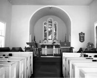
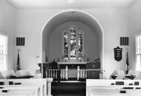
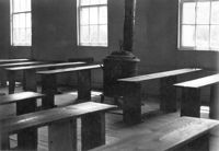
Christ Church Episcopal - Adams Run, State Highway 174. View of Interior. West (Front) elevation. Hollywood, S.C.;8" x 10" B/W photo. Box 16, Folder 2-11-12. One copy.
Christ Church Episcopal - Adams Run, State Highway 174. View of East (Rear) elevation. Hollywood, S.C.;8" x 10" B/W photo. Box 16, Folder 2-11-12. One copy.
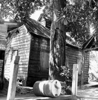
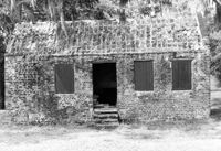
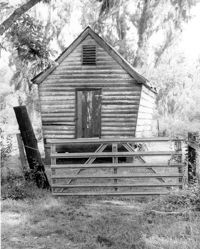
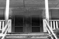
Boone Hall Plantation, Oak Avenue. Slave Cabin - View of SW (Side and Rear) elevation. Mount Pleasant, S.C.;8" x 10" B/W photo. Box 10, Folder 2-2-5. One copy.
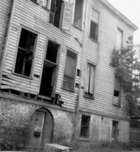
Shaw Community Center, 22 Mary Street. Main Building - View of South (Rear) elevation. Charleston, S.C. (NOTE: Structure demolished in 1974);8.25" x 7.5" B/W photo. Box 6, Folder 2-1-13. One copy.
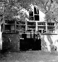
Shaw Community Center, 22 Mary Street. Coach House - View of NW elevation. Charleston, S.C. (NOTE: Structure demolished in 1974);8.25" x 7.5" B/W photo. Box 6, Folder 2-1-13. One copy.
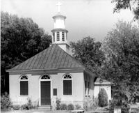
Christ Church Episcopal - Adams Run, State Highway 174. View of West (Front) elevation. Hollywood, S.C.;10" x 8" B/W photo. Box 16, Folder 2-11-12. One copy.
Magnolia Cemetery, Huguenin Avenue and Algonquin Road. Monument of Emma Heyward Haskell. Charleston, S.C.;8" x 8" B/W photo. Box 5, Folder 2-1-3. One copy.
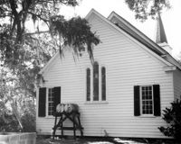
Christ Church (Christ Episcopal Church), 2304 U.S. Highway 17. View of North (Front) elevation. Mount Pleasant, S.C.;8" x 10" B/W photo. Box 10, Folder 2-2-6. One copy.
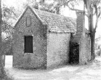
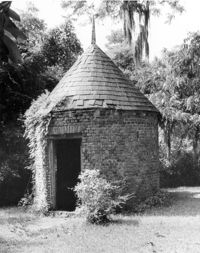
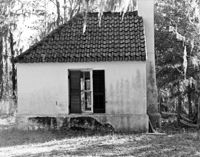
Bleak Hall Plantation, S.C. Hwy. 174. Smoke House - View of SW (Front) elevation. Edisto Island, S.C.;10" x 8" B/W photo. Box 10, Folder 2-3-2. One copy.
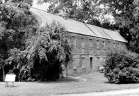
Boone Hall Plantation, Oak Avenue. Gin House - View of NE (Front) elevation, looking East. Mount Pleasant, S.C.;6.5" x 10" B/W photo. Box 10, Folder 2-2-5. One copy.
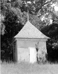
Boone Hall Plantation, Oak Avenue. Smoke House - View of NW (Front and Side) elevation. Mount Pleasant, S.C.;10" x 8" B/W photo. Box 10, Folder 2-2-5. One copy.
Boone Hall Plantation, Oak Avenue. Slave Cabin - View of North (Front) elevation. Mount Pleasant, S.C.;6.5" x 10" B/W photo. Box 10, Folder 2-2-5. One copy.
Boone Hall Plantation, Oak Avenue. Rat Proof Barn - View of South (Front) elevation. Mount Pleasant, S.C.;10" x 8" B/W photo. Box 10, Folder 2-2-5. One copy.
White Church (St. Thomas Church, The Brick Church), Off of Cainhoy Road. Vestry - View of Side elevation. Cainhoy, S.C.;8" x 10" B/W photo. Box 4, Folder 1-12-2. One copy.
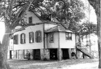
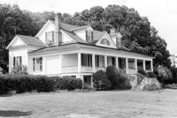
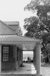
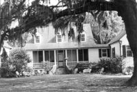
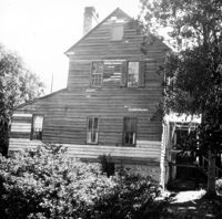
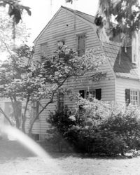
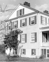
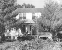
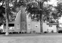
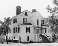
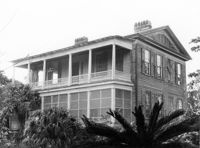
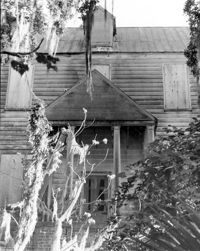
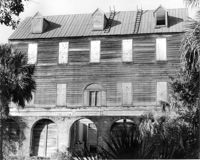
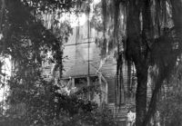
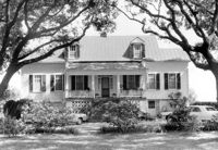
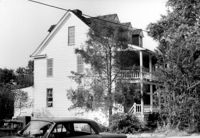
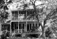
Oakland Plantation (Youghall Plantation), 1164 Porcher Bluff Road. Main House - View of SW (Side and Rear) elevation. Mount Pleasant, S.C.;10" x 8" B/W photo. Box 10, Folder 2-2-10. One copy.
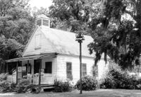
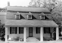
Oakland Plantation (Youghall Plantation), 1164 Porcher Bluff Road. Kitchen House - View of NE (Front) elevation. Mount Pleasant, S.C.;6.5" x 10" B/W photo. Box 10, Folder 2-2-10. One copy.
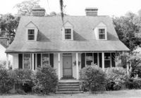
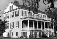
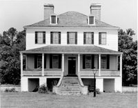
Oakland Plantation (Youghall Plantation), 1164 Porcher Bluff Road. Main House - View of North (Front) elevation. Mount Pleasant, S.C.;6.5" x 10" B/W photo. Box 10, Folder 2-2-10. One copy.
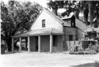
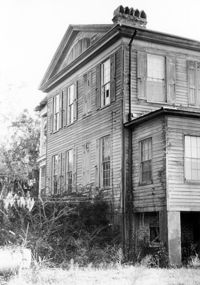
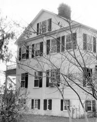
Oakland Plantation (Youghall Plantation), 1164 Porcher Bluff Road. Main House - View of South (Rear) elevation. Mount Pleasant, S.C.;6.5" x 10" B/W photo. Box 10, Folder 2-2-10. One copy.
Magnolia Cemetery, Huguenin Avenue and Algonquin Road. Monument of Sarah F., Charles F., and Elbert P. Jones. View of North elevation. Charleston, S.C.;10" x 8" B/W photo. Box 5, Folder 2-1-3. One copy.
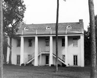
Peter's Point Plantation, off S.C. Hwy 174 on County Road 764 (Peters Point Road). View of North (Side and Front) elevation. Edisto Island, S.C.;6.5" x 10" B/W photo. Box 11, Folder 2-3-17. Two copies.
Peter's Point Plantation, off S.C. Hwy 174 on County Road 764 (Peters Point Road). View of West (Side and Rear) elevation. Edisto Island, S.C.;10" x 6.5" B/W photo. Box 11, Folder 2-3-17. One copy.
Windsor Plantation (Little Edisto Plantation, Ashwood Plantation), S.C. Hwy. 174. View of NE (Front and Side) elevation. Edisto Island, S.C.;6.5" x 10" B/W photo. Box 11, Folder 2-3-18. One copy.
Windsor Plantation (Little Edisto Plantation, Ashwood Plantation), S.C. Hwy. 174. View of NE (Side and Front) elevation. Edisto Island, S.C.;10" x 8" B/W photo. Box 11, Folder 2-3-18. One copy.
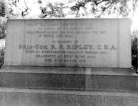
Magnolia Cemetery, Huguenin Avenue and Algonquin Road. Tombstone of R.S. Ripley. View of South elevation. Charleston, S.C.;8" x 10" B/W photo. Box 5, Folder 2-1-3. One copy.
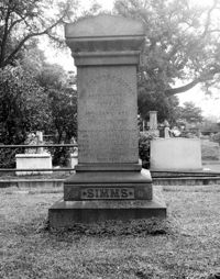
Magnolia Cemetery, Huguenin Avenue and Algonquin Road. Tombstone of William Gilmore Simms. Charleston, S.C.;10" x 8" B/W photo. Box 5, Folder 2-1-3. One copy.
Christ Church Episcopal - Adams Run, State Highway 174. View of Interior. West (Front) elevation. Hollywood, S.C.;6.5" x 10" B/W photo. Box 16, Folder 2-11-12. Three copies.
Christ Church Episcopal - Adams Run, State Highway 174. View of North (Side) elevation. Hollywood, S.C.;6.5" x 10" B/W photo. Box 16, Folder 2-11-12. Three copies.
Christ Church Episcopal - Adams Run, State Highway 174. View of West (Front) elevation. Hollywood, S.C.;10" x 6.5" B/W photo. Box 16, Folder 2-11-12. Three copies.
Christ Church Episcopal - Adams Run, State Highway 174. View of South (Side) elevation. Hollywood, S.C.;8" x 10" B/W photo. Box 16, Folder 2-11-12. One copy.
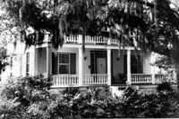
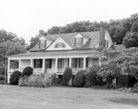
Rockville Historic District - Cornelia J. Whaley House, Grace Chapel Road. View of South (Front) elevation. Wadmalaw Island, S.C.;8" x 6.5" (and 6.5" x 10") B/W photo. Box 17, Folder 2-14-19. Three copies.
Magnolia Cemetery, Huguenin Avenue and Algonquin Road. Monument of Sarah F., Charles F., and Elbert P. Jones. View of East elevation. Charleston, S.C.;10" x 8" B/W photo. Box 5, Folder 2-1-3. One copy.
Magnolia Cemetery, Huguenin Avenue and Algonquin Road. Monument of Sarah F., Charles F., and Elbert P. Jones. View of West elevation. Charleston, S.C.;10" x 8" B/W photo. Box 5, Folder 2-1-3. One copy.
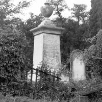
Magnolia Cemetery, Huguenin Avenue and Algonquin Road. Tombstone of Thomas Bennett. View of Front and Side elevation. Charleston, S.C.;8" x 8" B/W photo. Box 5, Folder 2-1-3. One copy.
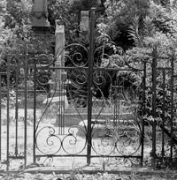
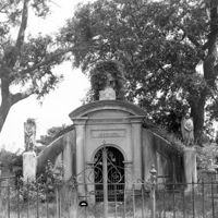
Magnolia Cemetery, Huguenin Avenue and Algonquin Road. Trapier-Jervey Gate. View of Front elevation. Charleston, S.C.;8" x 8" B/W photo. Box 5, Folder 2-1-3. One copy.
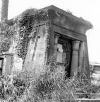
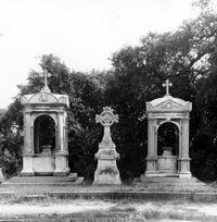
Magnolia Cemetery, Huguenin Avenue and Algonquin Road. Vanderhorst Mausoleum. View of Front and Side elevation. Charleston, S.C.;8" x 8" B/W photo. Box 5, Folder 2-1-3. One copy.
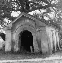
Magnolia Cemetery, Huguenin Avenue and Algonquin Road. Gibbes Mausoleum. View of Front elevation. Charleston, S.C.;8" x 8" B/W photo. Box 5, Folder 2-1-3. One copy.
Boone Hall Plantation, Oak Avenue. Stable - View of SW (Front and Side) elevation. Mount Pleasant, S.C.;6.5" x 10" B/W photo. Box 10, Folder 2-2-5. One copy.
Mount Pleasant Presbyterian Church, 302 Hibben Street (NE corner of Hibben and Church Street). View of SE (Front) elevation. Mount Pleasant, S.C.;6.5" x 10" (and 8" x 10") B/W photo. Box 13, Folder 2-8-6. Two copies.
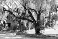
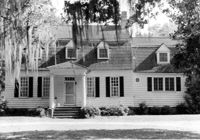
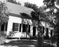
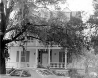
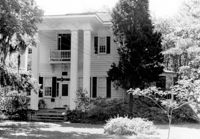
Captain Peter Lewis House, 206 Live Oak Drive. View of South (Front) elevation. Mount Pleasant, S.C.;6.5" x 10" B/W photo. Box 13, Folder 2-8-12. One copy.
Captain Peter Lewis House, 206 Live Oak Drive. View of South (Front) elevation. Mount Pleasant, S.C.;8" x 10" B/W photo. Box 13, Folder 2-8-12. Three copies.
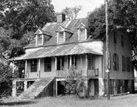
Dean Hall Plantation - Overseers House. View of East (Front) elevation. Oakley, SC. NOTE: Property relocated to Moncks Corner, S.C.;8" x 10" B/W photo. Box 2, Folder 1-8-9. One copy.
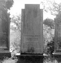
Magnolia Cemetery, Huguenin Avenue and Algonquin Road. Tombstone of R. Barnwell Rhett. View of ESE elevation. Charleston, S.C.;8" x 8" B/W photo. Box 5, Folder 2-1-3. One copy.
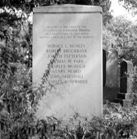
Magnolia Cemetery, Huguenin Avenue and Algonquin Road. Hunley Monument. View of North elevation. Charleston, S.C.;8" x 8" B/W photo. Box 5, Folder 2-1-3. One copy.
Peter's Point Plantation, off S.C. Hwy 174 on County Road 764 (Peters Point Road). View of NW (Front) elevation. Edisto Island, S.C.;6.5" x 10" B/W photo. Box 11, Folder 2-3-17. One copy.
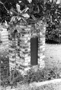
Quarter House Fort & Tavern Site, Success Street (between Meeting Street Road and Rivers Avenue). Detail View of Tavern Entrance Post and Historical Marker. Front and Side elevation. North Charleston, S.C.;10" x 6.5" B/W photo. Box 5, Folder 2-1-10. One copy.
Arnoldus Vander Horst House (Kiawah House), Mansion Court. Detail View of Entrance. South (Front) elevation. Kiawah Island, S.C.;10" x 8" B/W photo. Box 12, Folder 2-6-1. One copy.
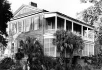
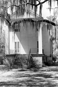
Arnoldus Vander Horst House (Kiawah House), Mansion Court. View of North (Rear) elevation. Kiawah Island, S.C.;8" x 10" B/W photo. Box 12, Folder 2-6-1. One copy.
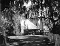
Arnoldus Vander Horst House (Kiawah House), Mansion Court. View of South (Front) elevation. Kiawah Island, S.C.;6.5" x 10" B/W photo. Box 12, Folder 2-6-1. One copy.
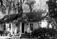
Halidon Hill Plantation (Quinby Plantation), Approximately 0.5 mile SE from Halidon Hill Lane and Cainhoy Road (S.C. Hwy 98). Main House - View of SW (Side and Front) elevation. Huger, S.C.;8" x 10" B/W photo. Box 4, Folder 1-12-6. One copy.
Magnolia Cemetery, Huguenin Avenue and Algonquin Road. Monument of Sarah F., Charles F., and Elbert P. Jones. View of South elevation. Charleston, S.C.;10" x 8" B/W photo. Box 5, Folder 2-1-3. One copy.
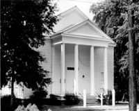
Rockville Historic District - Rockville Presbyterian Church, 2479 Sea Island Yacht Club Road. View of NW (Rear and Side) elevation. Wadmalaw Island, S.C.;6.5" x 10" B/W photo. Box 17, Folder 2-14-10. Two copies.
Rockville Historic District - Rockville Presbyterian Church, 2479 Sea Island Yacht Club Road. View of South (Front) elevation. Wadmalaw Island, S.C.;10" x 6.5" B/W photo. Box 17, Folder 2-14-10. One copy.
Rockville Historic District - Rockville Presbyterian Church, 2479 Sea Island Yacht Club Road. View of South (Front) elevation. Wadmalaw Island, S.C.;8" x 10" B/W photo. Box 17, Folder 2-14-10. One copy.
Captain Peter Lewis House, 206 Live Oak Drive. View of West (Side) elevation. Mount Pleasant, S.C.;6.5" x 10" B/W photo. Box 13, Folder 2-8-12. Two copies.
Secessionville Manor (Secessionville Plantation), Battallion Drive. View of NE (Side and Waterfront) elevation. Charleston, S.C.;6.5" x 10" B/W photo. Box 12, Folder 2-4-6. One copy.