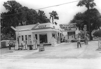
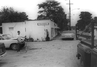
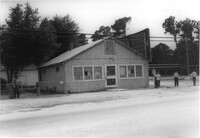
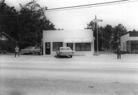
Gulf gas station, on site affected by the widening of State Road 13 (Remount Road). Surveyor notations on back of photo: "Dkt.: 10.562. Property owner: E.R. Gassman. Tract: 1. Date: Jul. 12, 1967." [See collection description for explanation of surveyor notations.]
Gulf gas station, on site affected by the widening of State Road 13 (Remount Road). Arrow Restaurant and Trucker's Billiard Academy across the street. Surveyor notations on back of photo: "Dkt.: 10.562. Property owner: E.R. Gassman. Tract: 1. Date: Jul. 12, 1967." [See collection description for explanation of surveyor notations.]
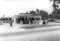
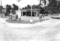
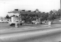
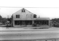
Shell gas station, on site affected by the widening of State Road 13 (Remount Road). Surveyor notations on back of photo: "Dkt.: 10.562. Property owner: Shell Oil Co., Inc. Tract: 2. Date: Jul. 12, 1967." [See collection description for explanation of surveyor notations.]
Shell gas station, on site affected by the widening of State Road 13 (Remount Road). Arrow Restaurant in background. Surveyor notations on back of photo: "Dkt.: 10.562. Property owner: Shell Oil Co., Inc. Tract: 2. Date: Jul. 12, 1967." [See collection description for explanation of surveyor notations.]
Shell gas station, on site affected by the widening of State Road 13 (Remount Road). Gulf gas Station: across the street. Surveyor notations on back of photo: "Dkt.: 10.562. Property owner: Shell Oil Co., Inc. Tract: 2. Date: Jul. 12, 1967." [See collection description for explanation of surveyor notations.]
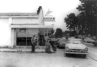
Arrow Restaurant, on site affected by the widening of State Road 13 (Remount Road). Surveyor notations on back of photo: "Dkt.: 10.562. Property owner: F.L. Parks, Jr. Tract: 3. Date: Jul. 12, 1967." [See collection description for explanation of surveyor notations.]
Arrow Restaurant and Trucker's Billiard Academy, on site affected by the widening of State Road 13 (Remount Road). Surveyor notations on back of photo: "Dkt.: 10.562. Property owner: F.L. Parks, Jr. Tract: 3. Date: Jul. 12, 1967." [See collection description for explanation of surveyor notations.]
Site affected by the widening of State Road 13 (Remount Road). Surveyor notations on back of photo: "Dkt.: 10.562. Property owner: F.L. Parks, Jr. Tract: 3. Date: Jul. 12, 1967." [See collection description for explanation of surveyor notations.]
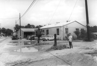
Avondale Laundry and Dry Cleaners, on site affected by the widening of State Road 13 (Remount Road). Trailer park in background. Surveyor notations on back of photo: "Dkt.: 10.562. Property owner: Edwards Realty Co. Tract: 4. Date: Jul. 12, 1967." [See collection description for explanation of surveyor notations.]
University of Wisconsin Community Action Technicians Alumni Association Newsletter, Volume 1, Number 4 (b), including information related to staff, members, and alumni.
Correspondence from Mrs. John C. Hawk, President of the Coming Street Y.W.C.A., to all Members of the Coming Street Y.W.C.A. regarding the upcoming annual meeting.
University of Wisconsin Community Action Technicians Alumni Association Newsletter, Volume 1, Number 4 (b), including information related to staff, members, and alumni.
University of Wisconsin Community Action Technicians Alumni Association Newsletter, Volume 1, Number 4 (a), including information related to staff, members, and alumni.
University of Wisconsin Community Action Technicians Alumni Association Newsletter, Volume 1, Number 4 (b), including information related to staff, members, and alumni.
University of Wisconsin Community Action Technicians Alumni Association Newsletter, Volume 1, Number 3, including information related to staff, members, and alumni.
University of Wisconsin Community Action Technicians Alumni Association Newsletter, Volume 1, Number 2, including information related to staff, members, and alumni.
University of Wisconsin Community Action Technicians Alumni Association Newsletter, Volume 1, Number 1, including information related to staff, members, and alumni.
Correspondence from Lila Parker, State Dept. of Public Welfare Division of Children and Youth, to Cynthia Maisel, Project Head Start, regarding training sessions for the Teaching Staff of Dane County Project Head Start.
One of four maps of King Street building footprints, hand-colored to designate status. This map illustrates the historical significance of buildings on King Street from Calhoun Street to Queen Street.
Correspondence from Marguerite D. Greene, Teenage Program Director for the Coming Street Y.W.C.A., to "Sunday School Superintendent" regarding Day Care matters.
Correspondence from Dora Smith, Y.W.C.A. Branch Kindergarten Teacher, to Parents regarding the upcoming Kindergarten P.T.A. Meeting to be held on December 4, 1967.
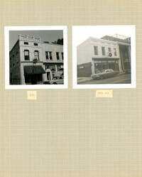
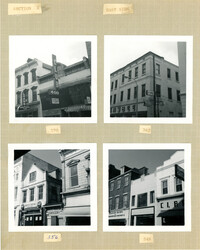
Two B&W photographs of buildings on the west side of King Street: Left (159-161): 159 King Street (Hildebrands) and 161 King Street; Right (201-203): 201 King Street (Castanes Grocery) and 203 King Street (later demolished for the construction of Victoria Center).
Correspondence from Edward Kronsberg of the Rivers Portrait Committee to J. Arthur Brown regarding an event unveiling a portrait of the Honorable L. Mendel Rivers.
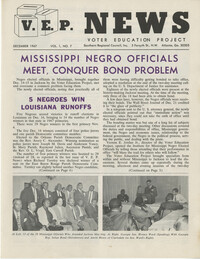
Voter Education Newsletter entitled, "V.E.P. News," Volume 1, Number 7, discussing various news items relating to voting rights as pertaining to African American voters and political candidates.
Correspondence from Lucille A. Williams, Chairman of the Coming Street Y.W.C.A., to Mrs. J. A. Edwards, Co-Chairman, to fellow members regarding a Game Party gala.
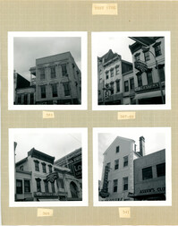
Three B&W photographs of buildings on the west side of King Street: Top left (337-339): 337 King Street (King's Restaurant) and 339 King Street (Fox Hi-Fi); Top right (331-335): 331 King Street, 333 King Street, and 335 King Street (Lesser-Tanenbaum); Bottom left (327-329): 327 King Street (Barton's Candy Card & Gift Shop) and 329 (Gloria Theater).
Avondale Laundry and Dry Cleaners, on site affected by the widening of State Road 13 (Remount Road). Trailer park in background. Surveyor notations on back of photo: "Dkt.: 10.562. Property owner: Edwards Realty Co. Tract: 4. Date: Jul. 12, 1967." [See collection description for explanation of surveyor notations.]
Correspondence from Christine O. Jackson to L. A. Williams an Geneve P. Singleton, Basileus and Tamiouchos of the Gamma Xi Omega Chapter of the Alpha Kappa Alpha Sorority, regarding a recent donation.
Correspondence from Mrs. M. A. Wilds, Chairman of The Adult Program Committee for the Coming Street Y.W.C.A., to Members and Associates regarding a "Family Dinner" to be held on July 22, 1967.
Four B&W photographs of buildings on the west side of King Street: Top left: 381 King Street (Felder's Rexall Drugs); Top right (367-369): 367 (Convertino's One Hour Cleaning) and 369 King Street (Lesser's Credit Jewelers); Bottom left (369-371): 369 King Street (Lesser's Credit Jewelers) and upper left portion of 371 King Street; Bottom right (341-343): 341 King Street (C.W. Kessler's) and 343 King Street (Askew's Clothiers).
Site affected by the widening of State Road 13 (Remount Road). Esso gas Station: in background. Surveyor notations on back of photo: "Dkt.: 10.562. Property owner: Edna M. Tant. Tract: 5. Date: Jul. 12, 1967." [See collection description for explanation of surveyor notations.]
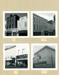
Four B&W photographs of buildings on the east side of King Street: Top left (340-342): 340 King Street (Charlie Gilik Tailor Shop) and 342 King Street (Dior's Wigs); Top right (334-338): 334 King Street (Elza's), 336 King Street, and 338 King Street; Bottom left (330-334): 330-332 King Street (Clement Furniture Co.) and 334 King Street (Elza's); Bottom right: 330-332 King Street (Clement Furniture Company).
Coming Street Y.W.C.A. memorandum from Gertrude Graves, Acting Secretary for the Coming Street Y.W.C.A., regarding the regular meeting of the Committee on Administration to be held on May 15, 1967.
Correspondence from Mrs. Joseph King, Chairman of the Committee on Administration for the Coming Street Y.W.C.A., and Christine O. Jackson, Branch Director, to Mrs. John C. Hawk, President of the Y.W.C.A. Board of Directors, and Mrs. Russell Long, Executive Director for the Coming Street Y.W.C.A., regarding budgetary matters.
Handwritten correspondence from Mrs. M. A. Wilds, Chairman of the Adult Program Committee for the Coming Street Y.W.C.A., to members regarding sponsorship.
Four B&W photographs of buildings on the east side of King Street: Top left (368-370): 368 King Street (Club 400) (demolished for parking lot) and 270 King Street (World Finance Corp.); Top right: 362-364 King Street (Kaybee); Bottom left (354-356): 354 King Street and 356 King Street (White House Grocery); Bottom right (344-348): 344 King Street (Clark Clothier), 346 King Street, and 348 King Street (American Arcade - American Mortgage Co.)
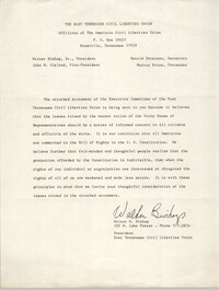
Statement from Walter H. Bishop, President of East Tennessee Civil Liberties Union, regarding "legislative investigation of Highlander Research and Educational Center."
Correspondence from Margery Ames to Bernice Robinson, former classmates at the University of Wisconsin's Community Action Technicians Training Program, discussing upcoming newsletters.
Correspondence from John C. Hawk, President of the Coming Street Y.W.C.A., to Joseph King, Chairman for the Committee on Administration for the Coming Street Y.W.C.A., regarding a financial statement.
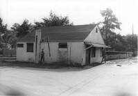
Mike's (possibly a garage), on site affected by the widening of State Road 13 (Remount Road). Trailer park in background. Surveyor notations on back of photo: "Dkt.: 10.562. Property owner: Edwards Realty Co. Tract: 5. Date: Jul. 12, 1967." [See collection description for explanation of surveyor notations.]
Correspondence from E. L. Jackson to Rev. C. D. Cooper, Pastor of the Westminster Presbyterian Church, regarding the Annual World Fellowship Vesper Service held on November 12, 1967.
Correspondence from John C. Hawk, President of the Coming Street Y.W.C.A., to Joseph King, Chairman for the Committee on Administration for the Coming Street Y.W.C.A., regarding a financial statement.
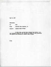
Memorandum from Erle Johnston, Jr., Director of Jackson State College regarding a closed meeting between the President of Jackson State student union and Student Nonviolent Coordinating Committee, NAACP and Black Panthers representative, et al. regarding the protest of the killing of Benjamin Brown and police brutality.
Memorandum from Erle Johnston, Jr., Director of Jackson State College regarding the arrival of Willie Ricks and Cleveland Sellers of the Student Nonviolent Coordinating Committee "to help perpetuate and agitate the situation at Jackson State College."
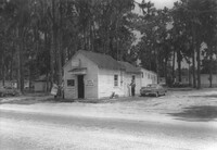
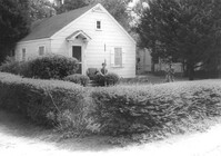
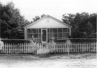
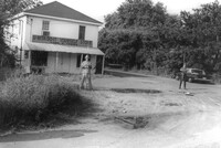
House on site affected by the widening of State Road 13 (Remount Road). 1548 Remount Road. Surveyor notations on back of photo: "Dkt.: 10.562. Property owner: Harry R. Parkinson, et al. Tract: 61. Date: Jul. 19, 1967." [See collection description for explanation of surveyor notations.]
House on site affected by the widening of State Road 13 (Remount Road). 1552 Remount Road. Surveyor notations on back of photo: "Dkt.: 10.562. Property owner: Robert W. Kimbel. Tract: 60. Date: Jul. 19, 1967." [See collection description for explanation of surveyor notations.]
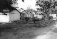
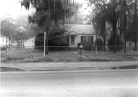
Houses on site affected by the widening of State Road 13 (Remount Road). Surveyor notations on back of photo: "Dkt.: 10.562. Property owner: James R. Robinson, Estate. Tract: 41. Date: Jul. 19, 1967." [See collection description for explanation of surveyor notations.]
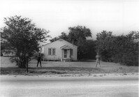
House on site affected by the widening of State Road 13 (Remount Road). Surveyor notations on back of photo: "Dkt.: 10.562. Property owner: Olivia Fleisher Estate. Tract: 38. Date: Jul. 19, 1967." [See collection description for explanation of surveyor notations.]
House on site affected by the widening of State Road 13 (Remount Road). Surveyor notations on back of photo: "Dkt.: 10.562. Property owner: Mrs. J.L. McFadyen. Tract: 69. Date: Jul. 19, 1967." [See collection description for explanation of surveyor notations.]
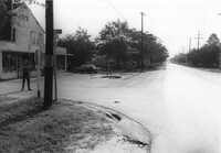
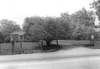
Site affected by the widening of State Road 13 (Remount Road). Surveyor notations on back of photo: "Dkt.: 10.562. Property owner: Barbara Pringle. Tract: 43. Date: Jul. 19, 1967." [See collection description for explanation of surveyor notations.]
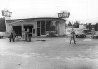
Crown gas station, on site affected by the widening of State Road 13 (Remount Road). Johnny's in back. Possibly the corner of North Rhett Avenue and Remount Road. Surveyor notations on back of photo: "Dkt.: 10.562. Property owner: Corco Realty Co. (Crown). Tract: 142. Date: Jul. 19, 1967." [See collection description for explanation of surveyor notations.]
Crown gas station, on site affected by the widening of State Road 13 (Remount Road). Possibly the corner of North Rhett Avenue and Remount Road. Surveyor notations on back of photo: "Dkt.: 10.562. Property owner: Corco Realty Co. (Crown). Tract: 142. Date: Jul. 19, 1967." [See collection description for explanation of surveyor notations.]
Esso gas station, on site affected by the widening of State Road 13 (Remount Road). Louie's Speed shop in background. Surveyor notations on back of photo: "Dkt.: 10.562. Property owner: Harry R. Williams. Tract: 113. Date: Jul. 19, 1967." [See collection description for explanation of surveyor notations.]
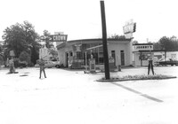
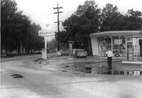
Atlantic gas station, on site affected by the widening of State Road 13 (Remount Road). Surveyor notations on back of photo: "Dkt.: 10.562. Property owner: Atlantic Refining Co. Tract: 37. Date: Jul. 19, 1967." [See collection description for explanation of surveyor notations.]
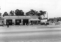
Texaco gas station, on site affected by the widening of State Road 13 (Remount Road). Surveyor notations on back of photo: "Dkt.: 10.562. Property owner: W.L. Dyches, et al. Tract: 23. Date: Jul. 12, 1967." [See collection description for explanation of surveyor notations.]
Johnny's (barber shop?), on site affected by the widening of State Road 13 (Remount Road). Surveyor notations on back of photo: "Dkt.: 10.562. Property owner: Fannie Lou Owens. Tract: 32. Date: Jul. 12, 1967." [See collection description for explanation of surveyor notations.]
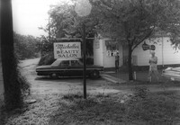
Michelle's Beauty Salon, on site affected by the widening of State Road 13 (Remount Road). Surveyor notations on back of photo: "Dkt.: 10.562. Property owner: Jerry Gray. Tract: 120. Date: Jul. 19, 1967." [See collection description for explanation of surveyor notations.]
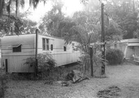
Mobile homes on site affected by the widening of State Road 13 (Remount Road). Surveyor notations on back of photo: "Dkt.: 10.562. Property owner: Charles R. Roberson. Tract: 36-A. Date: Jul. 19, 1967." [See collection description for explanation of surveyor notations.]
House on site affected by the widening of State Road 13 (Remount Road). Surveyor notations on back of photo: "Dkt.: 10.562. Property owner: M.R. Wilson. Tract: 25. Date: Jul. 12, 1967." [See collection description for explanation of surveyor notations.]
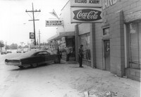
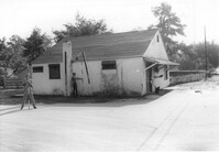
Building (former bar, with Miller High Life signs on windows), on site affected by the widening of State Road 13 (Remount Road). Surveyor notations on back of photo: "Dkt.: 10.562. Property owner: Fannie Lou Owens. Tract: 32. Date: Jul. 12, 1967." [See collection description for explanation of surveyor notations.]
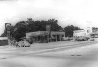
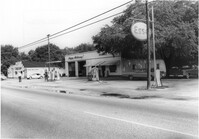
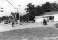
Gulf gas Station [Berkeley Gulf Service], on site affected by the widening of State Road 13 (Remount Road). Berkeley Drugs (Walgreens) in background. Surveyor notations on back of photo: "Dkt.: 10.562. Property owner: C.D. Hoffecker Estate. Tract: 24. Date: Jul. 12, 1967." [See collection description for explanation of surveyor notations.]
Gulf gas Station [Berkeley Gulf Service], on site affected by the widening of State Road 13 (Remount Road). Surveyor notations on back of photo: "Dkt.: 10.562. Property owner: C.D. Hoffecker Estate. Tract: 24. Date: Jul. 12, 1967." [See collection description for explanation of surveyor notations.]
Gulf gas Station [Berkeley Gulf Service], on site affected by the widening of State Road 13 (Remount Road), with directional signs for Yeaman's Hall and Hanahan Baptist Church. Surveyor notations on back of photo: "Dkt.: 10.562. Property owner: C.D. Hoffecker Estate. Tract: 24. Date: Jul. 12, 1967." [See collection description for explanation of surveyor notations.]
Kayo gas station, on site affected by the widening of State Road 13 (Remount Road). Surveyor notations on back of photo: "Dkt.: 10.562. Property owner: S.R. Hill - K.O. Station. Tract: 66. Date: Jul. 19, 1967." [See collection description for explanation of surveyor notations.]
Bowers Hardware, on site affected by the widening of State Road 13 (Remount Road). Surveyor notations on back of photo: "Dkt.: 10.562. Property owner: J.R. Herrin. Tract: 82. Date: Jul. 19, 1967." [See collection description for explanation of surveyor notations.]
Crown gas station, on site affected by the widening of State Road 13 (Remount Road). Possibly the corner of North Rhett Avenue and Remount Road. Surveyor notations on back of photo: "Dkt.: 10.562. Property owner: Corco Realty Co. (Crown). Tract: 142. Date: Jul. 19, 1967." [See collection description for explanation of surveyor notations.]
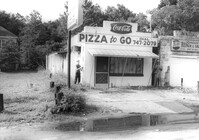
Little Italy pizza restaurant, next door to Remount Repair & Salvage, on site affected by the widening of State Road 13 (Remount Road). Surveyor notations on back of photo: "Dkt.: 10.562. Property owner: George Constantino. Tract: 116. Date: Jul. 19, 1967." [See collection description for explanation of surveyor notations.]
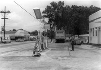
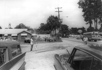
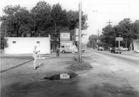
Building on site affected by the widening of State Road 13 (Remount Road). Corner view of building in State Road 13 Photo 34, corner of S-10-798 and Remount Road. View of street corner. Sign for the A&P across the street. Surveyor notations on back of photo: "Dkt.: 10.562. Property owner: Fannie Lou Owens. Tract: 32. Date: Jul. 12, 1967." [See collection description for explanation of surveyor notations.]
House on site affected by the widening of State Road 13 (Remount Road). (1488 Remount Road.) Surveyor notations on back of photo: "Dkt.: 10.562. Property owner: Mrs. J.L. McFadyen. Tract: 69. Date: Jul. 19, 1967." [See collection description for explanation of surveyor notations.]
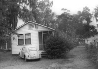
House on site affected by the widening of State Road 13 (Remount Road). Surveyor notations on back of photo: "Dkt.: 10.562. Property owner: Charles R. Roberson. Tract: 36. Date: Jul. 19, 1967." [See collection description for explanation of surveyor notations.]
House on site affected by the widening of State Road 13 (Remount Road). Surveyor notations on back of photo: "Dkt.: 10.562. Property owner: Charles R. Roberson. Tract: 36-A. Date: Jul. 19, 1967." [See collection description for explanation of surveyor notations.]
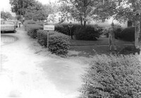
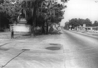
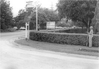
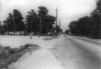
Site affected by the widening of State Road 13 (Remount Road). A&P barely visible in background. Surveyor notations on back of photo: "Dkt.: 10.562. Property owner: E.H. Eickmeyer. Tract: 35. Date: Jul. 19, 1967." [See collection description for explanation of surveyor notations.]
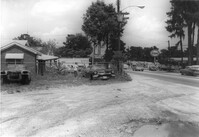
10-Mile News, on site affected by the widening of State Road 13 (Remount Road). Trailer park in background. Surveyor notations on back of photo: "Dkt.: 10.562. Property owner: Edna M. Tant. Tract: 5. Date: Jul. 12, 1967." [See collection description for explanation of surveyor notations.]
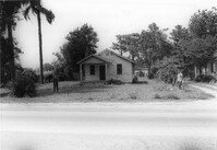
House on site affected by the widening of State Road 13 (Remount Road). Surveyor notations on back of photo: "Dkt.: 10.562. Property owner: Joseph W. Cooper. Tract: 9. Date: Jul. 12, 1967." [See collection description for explanation of surveyor notations.]
House on site affected by the widening of State Road 12 (Remount Road). Surveyor notations on back of photo: "Dkt.: 10.562. Property owner: Joseph W. Cooper. Tract: 9. Date: Jul. 12, 1967." [See collection description for explanation of surveyor notations.]
House on site affected by the widening of State Road 13 (Remount Road). View of street corner. Corner of Hardy Avenue and Remount Road. Directional sign for The Taxidermy House. Surveyor notations on back of photo: "Dkt.: 10.562. Property owner: Harry R. Parkinson, et al. Tract: 61. Date: Jul. 19, 1967." [See collection description for explanation of surveyor notations.]
House on site affected by the widening of State Road 13 (Remount Road). Surveyor notations on back of photo: "Dkt.: 10.562. Property owner: Mrs. J.L. McFadyen. Tract: 69. Date: Jul. 19, 1967." [See collection description for explanation of surveyor notations.]
House on site affected by the widening of State Road 13 (Remount Road). Surveyor notations on back of photo: "Dkt.: 10.562. Property owner: William M. Nelson. Tract: 111. Date: Jul. 19, 1967." [See collection description for explanation of surveyor notations.]
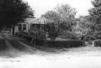
House on site affected by the widening of State Road 13 (Remount Road). Surveyor notations on back of photo: "Dkt.: 10.562. Property owner: Lolie Driggers. Tract: 80. Date: Jul. 19, 1967." [See collection description for explanation of surveyor notations.]
House on site affected by the widening of State Road 13 (Remount Road). Surveyor notations on back of photo: "Dkt.: 10.562. Property owner: Melbry Grimes. Tract: 91. Date: Jul. 19, 1967." [See collection description for explanation of surveyor notations.]
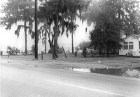
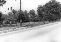
Site affected by the widening of State Road 13 (Remount Road). Surveyor notations on back of photo: "Dkt.: 10.562. Property owner: Elizabeth Gilmoor. Tract: 107. Date: Jul. 19, 1967." [See collection description for explanation of surveyor notations.]
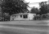
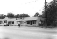
Law Offices of William Chrisanthis, on site affected by the widening of State Road 13 (Remount Road). Surveyor notations on back of photo: "Dkt.: 10.562. Property owner: Ethel Barnes Morris. Tract: 22. Date: Jul. 12, 1967." [See collection description for explanation of surveyor notations.]
Building (industrial use?) on site affected by the widening of State Road 13 (Remount Road). Texaco and Gulf gas stations in background, across street). Surveyor notations on back of photo: "Dkt.: 10.562. Property owner: A.G. Boone Co. Tract: 15. Date: Jul. 12, 1967." [See collection description for explanation of surveyor notations.]
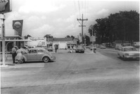
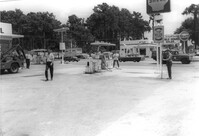
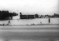
A&P store and parking lot, on site affected by the widening of State Road 13 (Remount Road). Surveyor notations on back of photo: "Dkt.: 10.562. Property owner: S.S. and B. Inc. Tract: 31. Date: Jul. 12, 1967." [See collection description for explanation of surveyor notations.]
A&P parking lot, on site affected by the widening of State Road 13 (Remount Road). Surveyor notations on back of photo: "Dkt.: 10.562. Property owner: S.S. and B. Inc. Tract: 31. Date: Jul. 12, 1967." [See collection description for explanation of surveyor notations.]
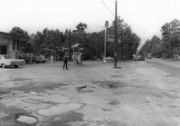
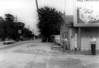
Lot next to McBride TV and Roy's Barber Shop, on site affected by the widening of State Road 13 (Remount Road). Atlantic gas Station: across the street. Surveyor notations on back of photo: "Dkt.: 10.562. Property owner: Pearl T. Leiderman. Tract: 40. Date: Jul. 19, 1967." [See collection description for explanation of surveyor notations.]
Bowers Hardware, on site affected by the widening of State Road 13 (Remount Road). Surveyor notations on back of photo: "Dkt.: 10.562. Property owner: J.R. Herrin. Tract: 82. Date: Jul. 19, 1967." [See collection description for explanation of surveyor notations.]
U-Nita-Do-It Yourself Store, on site affected by the widening of State Road 13 (Remount Road). Surveyor notations on back of photo: "Dkt.: 10.562. Property owner: John D. Stratos. Tract: 90. Date: Jul. 19, 1967." [See collection description for explanation of surveyor notations.]
Opal Oil Co., on site affected by the widening of State Road 13 (Remount Road). Gulf gas Station: across the street. Surveyor notations on back of photo: "Dkt.: 10.562. Property owner: Ethel Barnes Morris. Tract: 22. Date: Jul. 12, 1967." [See collection description for explanation of surveyor notations.]