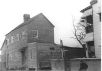
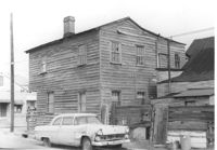
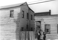
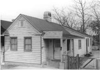
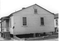
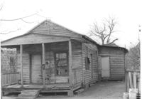
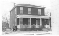
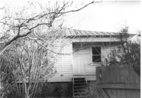
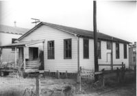
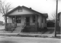
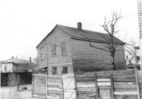
House on site affected by the construction of Interstate 26 (I-26). Address: 24 C Street. Surveyor notations on back of photo: "Dkt.: 10.517. Property owner: Dorothy Bolds, et al. Tract: 26. Station: 5945+80 Lt. - Line 6. Date: February 21, 1963. In R/W - Bought." [See collection description for explanation of surveyor notations.]
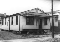
House (rear view) on site affected by the construction of Interstate 26 (I-26). Address: 24 C Street. Surveyor notations on back of photo: "Dkt.: 10.517. Property owner: Dorothy Bolds, et al. Tract: 26. Station: 5945+80 Lt. - Line 6. Date: February 21, 1963. In R/W - Bought." [See collection description for explanation of surveyor notations.]
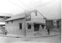
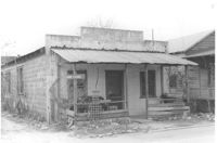
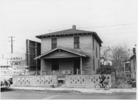
Washington Grocery on site affected by the construction of Interstate 26 (I-26). Address: northeast corner of E Street and C Street. View of street corner. Surveyor notations on back of photo: "Dkt.: 10.517. Property owner: Isaac Washington. Tract: 27. Station: 5946+55 Lt. - Line 6. Date: February 21, 1963." [See collection description for explanation of surveyor notations.]
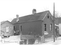
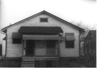
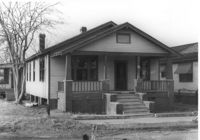
House on site affected by the construction of Interstate 26 (I-26). Address: southeast corner of E Street and C Street. View of street corner. Surveyor notations on back of photo: "Dkt.: 10.517. Property owner: Henry L. Perkins, et al. Tract: 28. Station: 5947+20 Lt. - Line 6. Date: February 21, 1963. In R/W - Bought." [See collection description for explanation of surveyor notations.]
House (rear view) on site affected by the construction of Interstate 26 (I-26). Address: southeast corner of E Street and C Street. Across the street from Washington Grocery. View of street corner. Surveyor notations on back of photo: "Dkt.: 10.517. Property owner: Henry L. Perkins, et al. Tract: 28. Station: 5947+20 Lt. - Line 6. Date: February 21, 1963. In R/W - Bought." [See collection description for explanation of surveyor notations.]
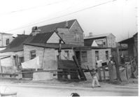
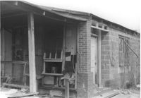
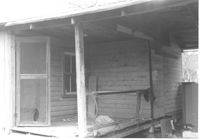
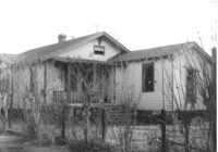
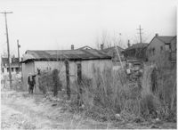
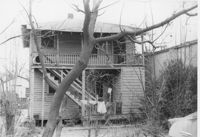
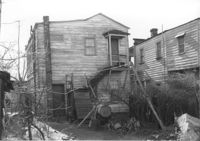
House in dilapidated condition (rear view) on site affected by the construction of Interstate 26 (I-26). Address: southeast corner of E Street and C Street, behind corner store. Surveyor notations on back of photo: "Dkt.: 10.517. Property owner: Arthur Lee Nelson. Tract: 29. Station: 5947+65 Lt. - Line 6. Date: February 21, 1963. In R/W - Bought." [See collection description for explanation of surveyor notations.]
Exterior wall of dilapidated house on site affected by the construction of Interstate 26 (I-26). Address: southeast corner of E Street and C Street, behind corner store. Surveyor notations on back of photo: "Dkt.: 10.517. Property owner: Arthur Lee Nelson. Tract: 29. Station: 5947+65 Lt. - Line 6. Date: February 21, 1963. In R/W - Bought." [See collection description for explanation of surveyor notations.]
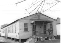
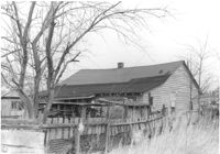
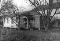
House in dilapidated condition (freedman's cottage) on site affected by the construction of Interstate 26 (I-26). Address: 6 C Street. Number 14 painted on brick by front door. Surveyor notations on back of photo: "Dkt.: 10.517. Property owner: Mary Wayman. Tract: 30. Station: 5948+20 Lt. - Line 6. Date: February 21, 1963. In R/W - Bought." [See collection description for explanation of surveyor notations.]
House in dilapidated condition (freedman's cottage?) on site affected by the construction of Interstate 26 (I-26). Address: 6 C Street. Number 14 painted on brick by front door. Surveyor notations on back of photo: "Dkt.: 10.517. Property owner: Mary Wayman. Tract: 30. Station: 5948+20 Lt. - Line 6. Date: February 21, 1963. In R/W - Bought." [See collection description for explanation of surveyor notations.]
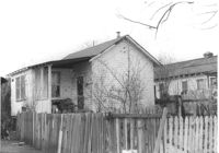
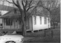
House (rear view) on site affected by the construction of the Crosstown. Address: 86 Hanover Street. Neighboring house also shown. Surveyor notations on back of photo: "Dkt.: 10.518. Property owner: Ester Bosser. Tract: 42. Station: 43+65 CL line 9 north of Cooper Street. Date: Mar. 6, 1963. In R/W - Bought. [See collection description for explanation of surveyor notations.]
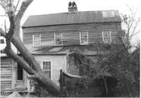
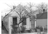
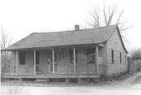
House (freedman's cottage) on site affected by the construction of Interstate 26 (I-26). Address: 20 C Street. (1951 Sanborn map indicates the address is 14 C Street.) Surveyor notations on back of photo: "Dkt.: 10.517. Property owner: Edward Gallashaw, et al. Tract: 31. Station: 5948+50 Lt. - Line 6. Date: February 21, 1963. In R/W - Bought." [See collection description for explanation of surveyor notations.]
House (freedman's cottage) (rear view) on site affected by the construction of Interstate 26 (I-26). Address: 20 C Street. (1951 Sanborn map indicates the address is 14 C Street.) Surveyor notations on back of photo: "Dkt.: 10.517. Property owner: Edward Gallashaw, et al. Tract: 31. Station: 5948+50 Lt. - Line 6. Date: February 21, 1963. In R/W - Bought." [See collection description for explanation of surveyor notations.]
House (freedman's cottage) (rear view) on site affected by the construction of Interstate 26 (I-26). Address: 18 C Street. (1951 Sanborn map indicates the address is 16 C Street.) Surveyor notations on back of photo: "Dkt.: 10.517. Property owner: Virgil German, et al. Tract: 32. Station: 5948+80 Lt. - Line 6. Date: February 21, 1963. In R/W - Bought." [See collection description for explanation of surveyor notations.]
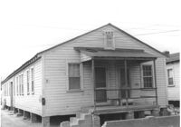
House (freedman's cottage) on site affected by the construction of Interstate 26 (I-26). Address: 18 C Street. (1951 Sanborn map indicates the address is 16 C Street.) Surveyor notations on back of photo: "Dkt.: 10.517. Property owner: Virgil German, et al. Tract: 32. Station: 5948+80 Lt. - Line 6. Date: February 21, 1963. In R/W - Bought." [See collection description for explanation of surveyor notations.]
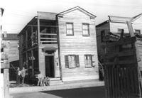
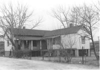
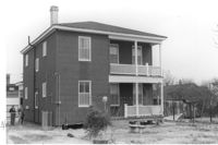
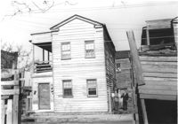
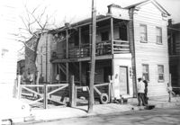
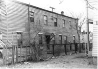
Dwelling on site affected by the construction of Interstate 26 (I-26). Address 13-27 C Street. Appears to be a multi-family residence. Surveyor notations on back of photo: "Dkt.: 10.517. Property owner: J.W.C. Bischoff. Tract: 33. Station: 5947+00 Lt. & Rt. CL. Date: February 21, 1963. In R/W - Bought." [See collection description for explanation of surveyor notations.]
Dwelling on site affected by the construction of Interstate 26 (I-26). Address 13-27 C Street. Appears to be a multi-family residence. Surveyor notations on back of photo: "Dkt.: 10.517. Property owner: J.W.C. Bischoff. Tract: 34. Station: 5947+40 Rt. & Lt. CL. Date: February 21, 1963. In R/W - Bought." [See collection description for explanation of surveyor notations.]
Dwelling on site affected by the construction of Interstate 26 (I-26). Address 13-27 C Street. Appears to be a multi-family residence. Surveyor notations on back of photo: "Dkt.: 10.517. Property owner: J.W.C. Bischoff. Tract: 35. Station: 5947+75 Rt. & Lt. CL. Date: February 21, 1963. In R/W - Bought." [See collection description for explanation of surveyor notations.]
Lot with three dwellings, on site affected by the construction of Interstate 26 (I-26). Address 13-27 C Street. Appears to be a multi-family residence. Surveyor notations on back of photo: "Dkt.: 10.517. Property owner: J.W.C. Bischoff. Tract: 34, 35, and 36. Station: 5947+00 - 5947+75 Rt. & Lt. Date: February 21, 1963. In R/W - Bought." [See collection description for explanation of surveyor notations.]
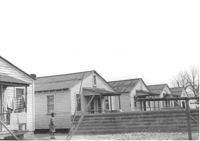
Lot with five dwellings, on site affected by the construction of Interstate 26 (I-26). Address 13-27 C Street. Appears to be a multi-family residence. Surveyor notations on back of photo: "Dkt.: 10.517. Property owner: J.W.C. Bischoff. Tract: 36, 37, 38, 39 & 40. Station: 5948+00 - 5949+70 Rt. & Lt. Date: February 21, 1963. In R/W - Bought." [See collection description for explanation of surveyor notations.]
Dwelling on site affected by the construction of Interstate 26 (I-26). Address 13-27 C Street. Appears to be a multi-family residence. Surveyor notations on back of photo: "Dkt.: 10.517. Property owner: J.W.C. Bischoff. Tract: 36. Station: 5948+10 Rt. & Lt. CL. Date: February 21, 1963. In R/W - Bought." [See collection description for explanation of surveyor notations.]
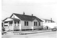
House on site affected by the construction of the Crosstown. Address: 68 Cooper Street. (Number on building is 78.) Surveyor notations on back of photo: "Dkt.: 10.518. Property owner: Ester Bosser. Tract: 42. Station: 44+65 Rt. line 9 north of Cooper Street. Date: Mar. 6, 1963. In R/W - Bought. [See collection description for explanation of surveyor notations.]
Dwelling on site affected by the construction of Interstate 26 (I-26). Address 13-27 C Street. Appears to be a multi-family residence. Surveyor notations on back of photo: "Dkt.: 10.517. Property owner: J.W.C. Bischoff. Tract: 37. Station: 5948+50 Rt. & Lt. Date: February 21, 1963. In R/W - Bought." [See collection description for explanation of surveyor notations.]
Dwelling on site affected by the construction of Interstate 26 (I-26). Address 13-27 C Street. Appears to be a multi-family residence. Surveyor notations on back of photo: "Dkt.: 10.517. Property owner: J.W.C. Bischoff. Tract: 38. Station: 5948+90 Rt. & Lt. CL. Date: February 21, 1963. In R/W - Bought." [See collection description for explanation of surveyor notations.]
Dwelling on site affected by the construction of Interstate 26 (I-26). Address 13-27 C Street. Appears to be a multi-family residence. Surveyor notations on back of photo: "Dkt.: 10.517. Property owner: J.W.C. Bischoff. Tract: 39. Station: 5949+20 Rt. & Lt. Line 2. Date: February 21, 1963. In R/W - Bought." [See collection description for explanation of surveyor notations.]
Dwelling on site affected by the construction of Interstate 26 (I-26). Address 11 C Street. Appears to be a multi-family residence. Surveyor notations on back of photo: "Dkt.: 10.517. Property owner: J.W.C. Bischoff. Tract: 40. Station: 5949+55 Rt. & Lt. Line 2. Date: February 21, 1963. In R/W - Bought." [See collection description for explanation of surveyor notations.]
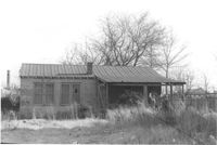
House (freedman's cottage?) on site affected by the construction of Interstate 26 (I-26). Address: 7 C Street. Surveyor notations on back of photo: "Dkt.: 10.517. Property owner: Cora G. Kelly, Est. Tract: 41. Station: 5950+00 Lt. Line 2. Date: February 21, 1963. In R/W - Bought." [See collection description for explanation of surveyor notations.]
House (freedman's cottage?) (rear view) on site affected by the construction of Interstate 26 (I-26). Address: 7 C Street. Surveyor notations on back of photo: "Dkt.: 10.517. Property owner: Cora G. Kelly, Est. Tract: 41. Station: 5950+00 Lt. Line 2. Date: February 21, 1963. In R/W - Bought." [See collection description for explanation of surveyor notations.]
House (rear view) on site affected by the construction of Interstate 26 (I-26). Address: 5 C Street. Surveyor notations on back of photo: "Dkt.: 10.517. Property owner: John B. Kelly, Est. Tract: 42. Station: 5950+30 Lt. Line 2. Date: February 21, 1963. In R/W - Bought." [See collection description for explanation of surveyor notations.]
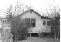
House in dilapidated condition on site affected by the construction of Interstate 26 (I-26). Address: 5 C Street. Surveyor notations on back of photo: "Dkt.: 10.517. Property owner: John B. Kelly, Est. Tract: 42. Station: 5950+30 Lt. Line 2. Date: February 21, 1963. In R/W - Bought." [See collection description for explanation of surveyor notations.]
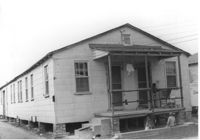
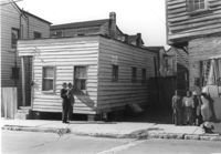
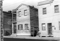
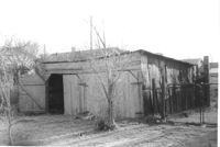
Dilapidated structure (possibly had commercial use) on site affected by the construction of Interstate 26 (I-26). Address: 3 C Street. "Saw Filing" sign posted on rail. Front facade has stepped parapet. Surveyor notations on back of photo: "Dkt.: 10.517. Property owner: J.W. Prescott. Tract: 43. Station: 5950+60 CL Line 2. Date: February 21, 1963. In R/W - Bought." [See collection description for explanation of surveyor notations.]
Dilapidated structure (rear view) on site affected by the construction of Interstate 26 (I-26). Address: 3 C Street. Surveyor notations on back of photo: "Dkt.: 10.517. Property owner: J.W. Prescott. Tract: 43. Station: 5950+60 CL - Line 2. Date: February 21, 1963. In R/W - Bought." [See collection description for explanation of surveyor notations.]
House on site affected by construction of the Crosstown. Address: 68 Cooper Street. (Number on building is 78.) Surveyor notations on back of photo: "Dkt.: 10.518. Property owner: Ester Bosser. Tract: 42. Station: 44+65 Rt. line 9 north of Cooper Street. Date: Mar. 6, 1963. In R/W - Bought. [See collection description for explanation of surveyor notations.]
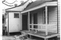
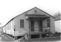
Porch of dilapidated structure on site affected by the construction of Interstate 26 (I-26). Address: 3 C Street. Surveyor notations on back of photo: "Dkt.: 10.517. Property owner: J.W. Prescott. Tract: 43. Station: 5950+60 CL - Line 2. Date: February 21, 1963. In R/W - Bought." [See collection description for explanation of surveyor notations.]
Dwelling on site affected by the construction of Interstate 26 (I-26). Address: 3 C Street. Surveyor notations on back of photo: "Dkt.: 10.517. Property owner: J.W. Prescott. Tract: 43. Station: 5950+60 CL Line 2. Date: February 21, 1963. In R/W - Bought." [See collection description for explanation of surveyor notations.]
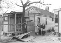
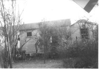
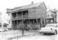
House (rear view) on site affected by the construction of Interstate 26 (I-26). Address: 1 C Street. Fenced in area with wooden shed in foreground. Surveyor notations on back of photo: "Dkt.: 10.517. Property owner: Ernie C. Swack. Tract: 44. Station: 5951+10 Lt. - Line 2. Date: February 21, 1963. In R/W - Bought." [See collection description for explanation of surveyor notations.]
House on site affected by the construction of Interstate 26 (I-26). Address: 1 C Street. Surveyor notations on back of photo: "Dkt.: 10.517. Property owner: Ernie C. Swack. Tract: 44. Station: 5951+10 Lt. - Line 2. Date: February 21, 1963. In R/W - Bought." [See collection description for explanation of surveyor notations.]
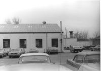
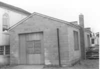
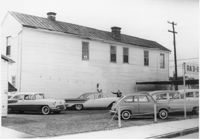
Ray Waits Mechanic/Body Shop (rear view) on site affected by the construction of Interstate 26 (I-26). Address: 11 Walnut Street. Surveyor notations on back of photo: "Dkt.: 10.517. Property owner: Roy Waites [sic] Motors, Inc. Tract: 45. Station: 5950+60 Lt. - Line 6. Date: February 21, 1963." [See collection description for explanation of surveyor notations.]
Ray Waits Mechanic/Body Shop (corner, one end of building, rear view) on site affected by the construction of Interstate 26 (I-26). Address: 11 Walnut Street. Surveyor notations on back of photo: "Dkt.: 10.517. Property owner: Roy Waites [sic] Motors, Inc. Tract: 45. Station: 5950±5950±67 Lt. Date: February 21, 1963." [See collection description for explanation of surveyor notations.]
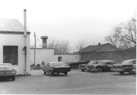
Ray Waits Mechanic/Body Shop (one end of building, front) on site affected by the construction of Interstate 26 (I-26). Address: 11 Walnut Street. Surveyor notations on back of photo: "Dkt.: 10.517. Property owner: Roy Waites [sic] Motors, Inc. Tract: 45. Station: 5950± Lt. - Line 6. Date: February 21, 1963." [See collection description for explanation of surveyor notations.]
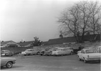
Parking lot of Ray Waits Mechanic/Body Shop, on site affected by the construction of Interstate 26 (I-26). Address: 11 Walnut Street. Surveyor notations on back of photo: "Dkt.: 10.517. Property owner: Roy Waites [sic] Motors, Inc. Tract: 45. Station: 5949+01 ±Rt. & lt. - Line 6. Date: February 21, 1963." [See collection description for explanation of surveyor notations.]
Ray Waits Mechanic/Body Shop (one end of building, front) on site affected by the construction of Interstate 26 (I-26). Address: 11 Walnut Street. Surveyor notations on back of photo: "Dkt.: 10.517. Property owner: Roy Waites [sic] Motors, Inc. Tract: 45. Station: 5950+70 Rt. - Line 6. Date: February 21, 1963. All in R/W." [See collection description for explanation of surveyor notations.]
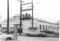
Ray Waits Mechanic/Body Shop on site affected by the construction of Interstate 26 (I-26). Address: 11 Walnut Street. Surveyor notations on back of photo: "Dkt.: 10.517. Property owner: Roy Waites [sic] Motors, Inc. Tract: 45. Station: 5950+55 Lt. - Line 6. Date: February 21, 1963." [See collection description for explanation of surveyor notations.]
House on site affected by the construction of the Crosstown. Address: 88 Hanover Street. Surveyor notations on back of photo: "Dkt.: 10.518. Property owner: Jerusalem Baptist Church. Tract: 43. Station: 43+90 CL line 9 north of Cooper Street. Date: Mar. 6, 1963." [See collection description for explanation of surveyor notations.]
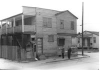
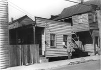
House on site affected by the construction of Interstate 26 (I-26). Address: 7 A Street (now 7 Walnut Street), at corner of C Street. Appears to be a duplex. Surveyor notations on back of photo: "Dkt.: 10.517. Property owner: H.B. Hogg, Est. Tract: 47. Station: 5951+80 Lt. - Line 6. Date: February 21, 1963. In R/W - Bought." [See collection description for explanation of surveyor notations.]
House (corner view, side or rear) on site affected by the construction of Interstate 26 (I-26). Address: 7 A Street (now 7 Walnut Street), at corner of C Street. Appears to be a duplex. Surveyor notations on back of photo: "Dkt.: 10.517. Property owner: H.B. Hogg, Est. Tract: 47. Station: 5951+80 Lt. - Line 6. Date: February 21, 1963. In R/W - Bought." [See collection description for explanation of surveyor notations.]
House (corner view, side or rear) on site affected by the construction of Interstate 26 (I-26). Address: 7½ A Street (now 7½ Walnut Street), at corner of C Street. Surveyor notations on back of photo: "Dkt.: 10.517. Property owner: H.B. Hogg, Est. Tract: 47. Station: 5951+85 Rt. - Line 6. Date: February 21, 1963. In R/W - Bought." [See collection description for explanation of surveyor notations.]
House on site affected by the construction of Interstate 26 (I-26). Address: 7½ A Street (now 7½ Walnut Street), at corner of C Street. Surveyor notations on back of photo: "Dkt.: 10.517. Property owner: H.B. Hogg, Est. Tract: 47. Station: 5951+85 Rt. - Line 6. Date: February 21, 1963. In R/W - Bought." [See collection description for explanation of surveyor notations.]
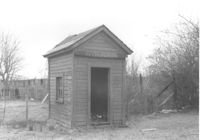
Small shed or possibly an outhouse, on site affected by the construction of Interstate 26 (I-26). Address: 7½ A Street (now 7½ Walnut Street), at corner of C Street. Surveyor notations on back of photo: "Dkt.: 10.517. Property owner: H.B. Hogg, Est. Tract: 47. Station: 5952+20 Lt. Date: February 21, 1963. In R/W - Bought." [See collection description for explanation of surveyor notations.]
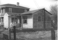
House (corner view, rear) on site affected by the construction of Interstate 26 (I-26). Address: 3 A Street (now 3 Walnut Street). Surveyor notations on back of photo: "Dkt.: 10.517. Property owner: Theresa H. Walker. Tract: 48. Station: 5952+70 Lt. - Line 6. Date: February 21, 1963. In R/W - Bought." [See collection description for explanation of surveyor notations.]
House on site affected by the construction of Interstate 26 (I-26). Address: 3 A Street (now 3 Walnut Street). Surveyor notations on back of photo: "Dkt.: 10.517. Property owner: Theresa H. Walker. Tract: 48. Station: 5952+70 Lt. - Line 6. Date: February 21, 1963. In R/W - Bought." [See collection description for explanation of surveyor notations.]
House on site affected by the construction of Interstate 26 (I-26). Address: 1 A Street (now 1 Walnut Street). Surveyor notations on back of photo: "Dkt.: 10.517. Property owner: Theresa H. Walker. Tract: 49. Station: 5953+15 Lt. - Line 6. Date: February 21, 1963. In R/W - Bought." [See collection description for explanation of surveyor notations.]
House (corner view, rear) on site affected by the construction of Interstate 26 (I-26). Address: 1 A Street (now 11 Walnut Street). Surveyor notations on back of photo: "Dkt.: 10.517. Property owner: Theresa H. Walker. Tract: 49. Station: 5953+15 Lt. - Line 6. Date: February 21, 1963. In R/W - Bought." [See collection description for explanation of surveyor notations.]
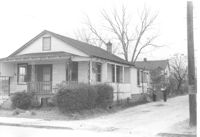
House on site affected by the construction of Interstate 26 (I-26). Address: 90 Lee Street. Surveyor notations on back of photo: "Dkt.: 10.517. Property owner: Lillian M. Simmons. Tract: 50. Station: 5954+15 CL - Line 6. Date: February 21, 1963. In R/W - Bought." [See collection description for explanation of surveyor notations.]
House on site affected by the construction of the Crosstown. Address: 88 Hanover Street. Surveyor notations on back of photo: "Dkt.: 10.518. Property owner: Jerusalem Baptist Church. Tract: 43. Station: 43+90 CL line 9 north of Cooper Street. Date: Mar. 6, 1963." [See collection description for explanation of surveyor notations.]
House (rear view) on site affected by the construction of Interstate 26 (I-26). Address: 90 Lee Street. Surveyor notations on back of photo: "Dkt.: 10.517. Property owner: Lillian M. Simmons. Tract: 50. Station: 5954+15 CL - Line 6. Date: February 21, 1963. In R/W - Bought." [See collection description for explanation of surveyor notations.]
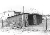
Large shed or garage on site affected by the construction of Interstate 26 (I-26). Address: 90 Lee Street. Surveyor notations on back of photo: "Dkt.: 10.517. Property owner: Lillian M. Simmons. Tract: 50. Station: 5953+50 Lt. - Line 6. Date: February 21, 1963. In R/W - Bought." [See collection description for explanation of surveyor notations.]
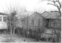
Wooden structures (sheds?) on site affected by the construction of Interstate 26 (I-26). Address: 92 Lee Street (rear). Surveyor notations on back of photo: "Dkt.: 10.517. Property owner: Robert L. Chamberlain, et al. Tract: 51. Station: 5953+60 CL - Line 6. Date: February 21, 1963. In R/W - Bought." [See collection description for explanation of surveyor notations.]
House on site affected by the construction of Interstate 26 (I-26). Address: 92 Lee Street (rear). Surveyor notations on back of photo: "Dkt.: 10.517. Property owner: Robert L. Chamberlain, et al. Tract: 51. Station: 5953+60 CL - Line 6. Date: February 21, 1963. In R/W - Bought." [See collection description for explanation of surveyor notations.]
House (corner view, rear) on site affected by the construction of Interstate 26 (I-26). Address: 92 Lee Street. Surveyor notations on back of photo: "Dkt.: 10.517. Property owner: Robert L. Chamberlain, et al. Tract: 51. Station: 5954+15 CL - Line 5. Date: February 21, 1963. In R/W - Bought." [See collection description for explanation of surveyor notations.]
House on site affected by the construction of Interstate 26 (I-26). Address: 92 Lee Street. Surveyor notations on back of photo: "Dkt.: 10.517. Property owner: Robert L. Chamberlain, et al. Tract: 51. Station: 5954+15 CL - Line 5. Date: February 21, 1963. In R/W - Bought." [See collection description for explanation of surveyor notations.]
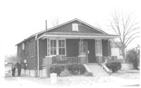
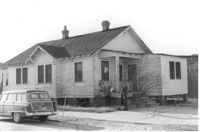
House on site affected by the construction of Interstate 26 (I-26). Address: 94 Lee Street. Surveyor notations on back of photo: "Dkt.: 10.517. Property owner: Andrew M. Hendricksen. Tract: 52. Station: 5954+00 Lt. Main Line. Date: February 21, 1963. In R/W - Bought." [See collection description for explanation of surveyor notations.]
House (rear view) on site affected by the construction of Interstate 26 (I-26). Address: 94 Lee Street. Surveyor notations on back of photo: "Dkt.: 10.517. Property owner: Andrew M. Hendricksen. Tract: 52. Station: 5954+00 Lt. Date: February 21, 1963. In R/W - Bought." [See collection description for explanation of surveyor notations.]
House (rear view) on site affected by the construction of Interstate 26 (I-26). Address: 96 Lee Street. Surveyor notations on back of photo: "Dkt.: 10.517. Property owner: Maude D. Scott. Tract: 53. Station: 5954+00 CL. Date: February 21, 1963. In R/W - Bought." [See collection description for explanation of surveyor notations.]
House on site affected by the construction of Interstate 26 (I-26). Address: 96 Lee Street. Surveyor notations on back of photo: "Dkt.: 10.517. Property owner: Maude D. Scott. Tract: 53. Station: 5954+00 CL. Date: February 21, 1963. In R/W - Bought." [See collection description for explanation of surveyor notations.]
House on site affected by the construction of the Crosstown. Address: 90 Hanover Street. Surveyor notations on back of photo: "Dkt.: 10.518. Property owner: Jerusalem Baptist Church. Tract: 44. Station: 44+20 CL line 9 north of Cooper Street. Date: Mar. 6, 1963." [See collection description for explanation of surveyor notations.]
House on site affected by the construction of Interstate 26 (I-26). Address: 96 Lee Street. Surveyor notations on back of photo: "Dkt.: 10.517. Property owner: Maude D. Scott. Tract: 53. Station: 5954+00 CL. Date: February 21, 1963. In R/W - Bought." [See collection description for explanation of surveyor notations.]
House (corner view, rear) on site affected by the construction of Interstate 26 (I-26). Address: 95 Lee Street. Surveyor notations on back of photo: "Dkt.: 10.517. Property owner: Church of God of Prophecy. Tract: 54. Station: 5955+00 CL. Date: February 21, 1963. In R/W - Bought." [See collection description for explanation of surveyor notations.]
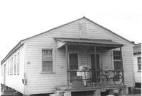
House on site affected by the construction of Interstate 26 (I-26). Address: 95 Lee Street. Surveyor notations on back of photo: "Dkt.: 10.517. Property owner: Church of God of Prophecy. Tract: 54. Station: 5955+00 CL. Date: February 21, 1963. In R/W - Bought." [See collection description for explanation of surveyor notations.]
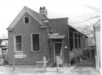
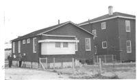
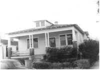
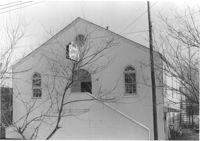
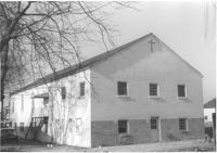
Building -- Church of God of Prophecy -- on site affected by the construction of Interstate 26 (I-26). Address: 93 Lee Street. Surveyor notations on back of photo: "Dkt.: 10.517. Property owner: Church of God of Prophecy. Tract: 55. Station: 5955+15 Lt. Main Line. 34+00 Lt. & Rt. Route 17. Date: February 21, 1963. In R/W - Bought." [See collection description for explanation of surveyor notations.]
Building (rear view, corner) -- Church of God of Prophecy -- on site affected by the construction of Interstate 26 (I-26). Address: 93 Lee Street. Surveyor notations on back of photo: "Dkt.: 10.517. Property owner: Church of God of Prophecy. Tract: 55. Station: 5955+15 Lt. Main Line. 34+00 Lt. & Rt. Route 17. Date: February 21, 1963. In R/W - Bought." [See collection description for explanation of surveyor notations.]
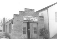
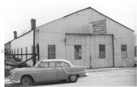
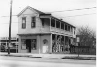
Collins Auto Glass Service on site affected by the construction of Interstate 26 (I-26). Address: 91 Lee Street. Front facade has stepped parapet. Surveyor notations on back of photo: "Dkt.: 10.517. Property owner: W.H. Yon. Tract: 56. Station: 34+30 Lt. - Route 17. Date: February 21, 1963." [See collection description for explanation of surveyor notations.]
Collins Auto Glass Service (rear view) on site affected by the construction of Interstate 26 (I-26). Address: 91 Lee Street. Surveyor notations on back of photo: "Dkt.: 10.517. Property owner: W.H. Yon. Tract: 56. Station: 34+30 Lt. - Route 17. Date: February 21, 1963." [See collection description for explanation of surveyor notations.]
Structure in grassy lot, that looks like a dwelling but has Body Shop painted on side of building, on site affected by the construction of Interstate 26 (I-26). Address: 91 Lee Street (rear). Surveyor notations on back of photo: "Dkt.: 10.517. Property owner: W.H. Yon. Tract: 56. Station: 34+40 Rt. - Route 17. Date: February 21, 1963." [See collection description for explanation of surveyor notations.]
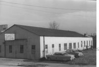
Garbini Auto Service -- General Auto Repair - Body and Paint Shop, on site affected by the construction of Interstate 26 (I-26). Address: 89 Lee Street. Surveyor notations on back of photo: "Dkt.: 10.517. Property owner: W.H. Yon. Tract: 56. Station: 35+20 CL - Route 17. Date: February 21, 1963. Partially in R/W." [See collection description for explanation of surveyor notations.]
Garbini Auto Service -- General Auto Repair - Body and Paint Shop, on site affected by the construction of Interstate 26 (I-26). Address: 89 Lee Street. Surveyor notations on back of photo: "Dkt.: 10.517. Property owner: W.H. Yon. Tract: 56. Station: 35+20 CL - Route 17. Date: February 21, 1963. Partially in R/W." [See collection description for explanation of surveyor notations.]
House on site affected by the construction of the Crosstown. Address: 90 Hanover Street. Surveyor notations on back of photo: "Dkt.: 10.518. Property owner: Jerusalem Baptist Church. Tract: 44. Station: 44+20 CL line 9 north of Cooper Street. Date: Mar. 6, 1963." [See collection description for explanation of surveyor notations.]
House on corner lot, on site affected by the construction of Interstate 26 (I-26). Address: 2 A Street (now 2 Walnut Street). View of street corner. Surveyor notations on back of photo: "Dkt.: 10.517. Property owner: Hattie Quidley Rollins Gunn. Tract: 57. Station: 5955+00 Lt. - Line 6. Date: February 21, 1963." [See collection description for explanation of surveyor notations.]
House on corner lot (corner view, rear), on site affected by the construction of Interstate 26 (I-26). Address: 2 A Street (now 2 Walnut Street). Surveyor notations on back of photo: "Dkt.: 10.517. Property owner: Hattie Quidley Rollins Gunn. Tract: 57. Station: 5955+00 Lt. - Line 6. Date: February 21, 1963." [See collection description for explanation of surveyor notations.]
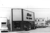
Gibson Tire Service on site affected by the construction of Interstate 26 (I-26). Address: 521 Meeting Street or 523 Meeting Street. Corner of Meeting Street and Lee Street. Surveyor notations on back of photo: "Dkt.: 10.517. Property owner: Thomas P. Gibson. Tract: 59. Station: 36+15 - 37+03 Rt. & Lt. Route 17. Date: February 21, 1963. All in R/W." [See collection description for explanation of surveyor notations.]
Gibson Tire Service on site affected by the construction of Interstate 26 (I-26). Address: 521 Meeting Street or 523 Meeting Street. Corner of Meeting Street and Lee Street. Surveyor notations on back of photo: "Dkt.: 10.517. Property owner: Thomas P. Gibson. Tract: 59. Station: 36+50 Rt. & Lt. Southbound Route 17. Date: May 30, 1963." [See collection description for explanation of surveyor notations.]
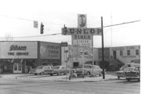
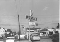
Gibson Tire Service on site affected by the construction of Interstate 26 (I-26). Address: 521 Meeting Street or 523 Meeting Street. Corner of Meeting Street and Lee Street. Sign for Dunlop Tires. View from street corner, showing intersection with directional signage for Route 17 and Route 701 and distances to nearby towns. Surveyor notations on back of photo: "Dkt.: 10.517. Property owner: Thomas P. Gibson. Tract: 59. Station: 36±00 - 37±00 Rt. & Lt. Route 17. Date: February 21, 1963. All in R/W." [See collection description for explanation of surveyor notations.]
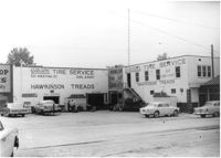
Gibson Tire Service / Hawkinson Treads on site affected by the construction of Interstate 26 (I-26). Address: 521 Meeting Street or 523 Meeting Street. Corner of Meeting Street and Lee Street. Surveyor notations on back of photo: "Dkt.: 10.517. Property owner: Thomas P. Gibson. Tract: 59. Station: 36+50 Rt. & Lt. Southbound Route 17. Date: May 30, 1963." [See collection description for explanation of surveyor notations.]
Gibson Tire Service / Hawkinson Treads on site affected by the construction of Interstate 26 (I-26). Address: 85 Lee Street. Corner of Lee Street and Meeting Street. Surveyor notations on back of photo: "Dkt.: 10.517. Property owner: Thomas P. Gibson. Tract: 59. Station: 36±00 - 37±00 Rt. & Lt. Route 17. Date: February 21, 1963. All in R/W." [See collection description for explanation of surveyor notations.]
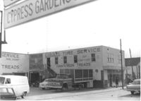
Commercial building, appears to be vacant, next door to Gibson Tire Service, on site affected by the construction of Interstate 26 (I-26). Address: 85 Lee Street. Corner of Lee Street and Meeting Street. Sign: Thrift time-Values-Savings-Storewide Bargains in background. Surveyor notations on back of photo: "Dkt.: 10.517. Property owner: Thomas P. Gibson. Tract: 59. Station: 36±00 - 37±00 Rt. & Lt. Route 17. Date: February 21, 1963. All in R/W." [See collection description for explanation of surveyor notations.]
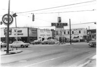
Busy intersection on site affected by the construction of Interstate 26 (I-26). Address: intersection of Lee Street and Meeting Street. Pure gas station, Gibson Tire Service / Dunlop Tires, and Sinclair gas station in view. Surveyor notations on back of photo: "Dkt.: 10.517. Property owner: Thomas P. Gibson. Tract: 59. Station: 37±00 Lt. - Route 17. Date: February 21, 1963. All in R/W." [See collection description for explanation of surveyor notations.]
Busy intersection on site affected by the construction of Interstate 26 (I-26). Address: intersection of Lee Street and meeting Street. Features Gibson Tire Service / Dunlop Tires; sign for Pure gas station in left foreground. Surveyor notations on back of photo: "Dkt.: 10.517. Property owner: Thomas P. Gibson. Tract: 59. Station: 37±00 Lt. - Route 17 survey. Date: March 5, 1963. All in R/W." [See collection description for explanation of surveyor notations.]
House on site affected by the construction of the Crosstown. Address: 92 Hanover Street. (Number on front door: 104. Portion of neighboring house at right; number painted on front door: 102.) Surveyor notations on back of photo: "Dkt.: 10.518. Property owner: Jerusalem Baptist Church. Tract: 45. Station: 44+60 CL line 9 east of Hanover Street. Date: Mar. 6, 1963." [See collection description for explanation of surveyor notations.]
House (corner view, rear) on site affected by the construction of Interstate 26 (I-26). Address: 518½ Meeting Street. Surveyor notations on back of photo: "Dkt.: 10.517. Property owner: Mrs. Bessie Rosen. Tract: 60. Station: 5959+80 CL - Line 6. Date: March 5, 1963. In R/W - Bought." [See collection description for explanation of surveyor notations.]
House (corner view, rear) on site affected by the construction of Interstate 26 (I-26). Address: 518½ Meeting Street. Wooden fence in foreground. Surveyor notations on back of photo: "Dkt.: 10.517. Property owner: Mrs. Bessie Rosen. Tract: 60. Station: 5959+80 CL - Line 6. Date: March 5, 1963. In R/W - Bought." [See collection description for explanation of surveyor notations.]
Shed or garage on site affected by the construction of Interstate 26 (I-26). Address: 516½ Meeting Street. Surveyor notations on back of photo: "Dkt.: 10.517. Property owner: Helen Phillips Brown, et al. Tract: 60-A. Station: 5960±40 Lt. - Line 6. Date: March 5, 1963. In R/W - Bought." [See collection description for explanation of surveyor notations.]
Wooden structure (shed or garage?) (rear view) on site affected by the construction of Interstate 26 (I-26). Address: 23 Jacobs Court. Surveyor notations on back of photo: "Dkt.: 10.517. Property owner: Furman G. Owens. Tract: 60-B. Station: 40+00 Lt. Northbound Lane, 5960+40 Lt. - Line 6. Date: March 5, 1963. In R/W - Bought." [See collection description for explanation of surveyor notations.]
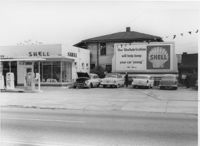
Shell gas station on site affected by the construction of Interstate 26 (I-26). Address: 512 Meeting Street. Surveyor notations on back of photo: "Dkt.: 10.517. Property owner: Shell Oil Co. Tract: 61. Station: 5961+50 Rt. - Line 6. Date: March 5, 1963. Proximity." [See collection description for explanation of surveyor notations.]
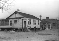
House on site affected by the construction of Interstate 26 (I-26). Address: 86 Cooper Street. Shell gas station (previous photo) in background. Surveyor notations on back of photo: "Dkt.: 10.517. Property owner: Nellie T. France. Tract: 62. Station: 5961+60 Rt. - Line 6. Date: March 5, 1963. In R/W - Bought." [See collection description for explanation of surveyor notations.]
House (rear view) on site affected by the construction of Interstate 26 (I-26). Address: 86 Cooper Street. Surveyor notations on back of photo: "Dkt.: 10.517. Property owner: Nellie T. France. Tract: 62. Station: 5961+60 Rt. - Line 6. Date: March 5, 1963. In R/W - Bought." [See collection description for explanation of surveyor notations.]
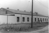
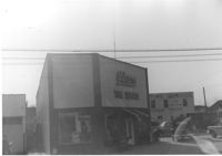
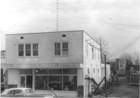
Building (Infinger's Shoe Service) (side view) on site affected by the construction of Interstate 26 (I-26). Address: 508 Meeting Street. Parking area in foreground. Surveyor notations on back of photo: "Dkt.: 10.517. Property owner: Pandora Co. Tract: 63. Station: 5963+00 CL - Line 6. Date: March 5, 1963. Partially in R/W. Men [in photo] In R/W." [See collection description for explanation of surveyor notations.]
Infinger's Shoe Service on site affected by the construction of Interstate 26 (I-26). Address: 508 Meeting Street. Surveyor notations on back of photo: "Dkt.: 10.517. Property owner: Pandora Co. Tract: 63. Station: 5963+00 CL - Line 6. Date: March 5, 1963. Partially in R/W." [See collection description for explanation of surveyor notations.]
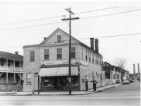
Corner grocery store on site affected by the construction of Interstate 26 (I-26). Address: 506 Meeting Street. View of street corner (northwest corner of Meeting Street and Sheppard Street). Smokestacks in background (Cigar Factory?). Surveyor notations on back of photo: "Dkt.: 10.517. Property owner: Rose D. Brady. Tract 64. Station: 5963+50 Lt. - Line 6. Date: March 5, 1963. Partially in R/W." [See collection description for explanation of surveyor notations.]
House (rear view) on site affected by the construction of the Crosstown. Address: 92 Hanover Street. (Number on front door: 104.) Surveyor notations on back of photo: "Dkt.: 10.518. Property owner: Jerusalem Baptist Church. Tract: 45. Station: 44+60 CL line 9 east of Hanover Street. Date: Mar. 6, 1963." [See collection description for explanation of surveyor notations.]
Corner grocery store? (side view) on site affected by the construction of Interstate 26 (I-26). Address: 506 Meeting Street (northwest corner of Meeting Street and Sheppard Street). Signage for a gas station in background (partially visible). Surveyor notations on back of photo: "Dkt.: 10.517. Property owner: Rose D. Brady. Tract 64. Station: 5963+50 Lt. - Line 6. Date: March 5, 1963. Partially in R/W." [See collection description for explanation of surveyor notations.]
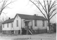
House (freedman's cottage) on site affected by the construction of Interstate 26 (I-26). Address: 146 Cooper Street. (1951 Sanborn map indicates the address is 94-92A Cooper Street.) Surveyor notations on back of photo: "Dkt.: 10.517. Property owner: Felix J. McKnight, et al. Tract: 65. Station: 5957+85 Lt. - Line 4. Date: March 5, 1963. All in R/W." [See collection description for explanation of surveyor notations.]