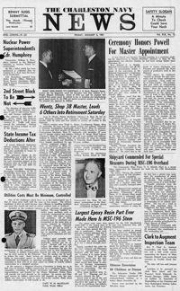
Newspaper printed for the civilian employees of the Charleston Naval Shipyard starting on January 6th 1961. This volume covers from January 6th 1961 to December 29rd 1961.
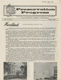
This newsletter from the Preservation Society of Charleston provides an update on the Plantation House at the Navy Yard; the Lining House; the Primrose House; the Gadsden House; 42 Society Street; 48 Laurens Street; 179 Rutledge Avenue; 6 Chalmers Street, the Old Slave Mart; 72 Tradd Street; and 1 Pitt Street.
Transcriptions of Rabbi Padoll’s typewritten and handwritten sermons and addresses from his various rabbinates, including Charleston’s Kahal Kadosh Beth Elohim. A civil rights advocate, Padoll discusses ongoing struggles for social justice, contemporary events such as the assassination of Robert F. Kennedy, and parables related to the Sabbath and holiday celebrations. Padoll stored his sermons in nine binders, and the transcriptions reflect this original order. Burton L. Padoll (1929-2004), was born to Leah and Charles Padoll in Canton, Ohio. Padoll attended the Hebrew Union College in Cincinnati, Ohio, where he was ordained in 1957 and received an honorary Doctorate of Divinity in 1982. After his ordination, Padoll served as assistant rabbi in Brookline, Massachusetts. In 1961, Padoll took a position as rabbi of Kahal Kadosh Beth Elohim (KKBE) in Charleston, South Carolina, where he served for six years. During this time, Padoll strongly advocated for civil rights and criticized Charleston's Jewish community for their failure to aid the struggle for racial equality. After leaving Charleston in 1967, Padoll moved to Peabody, Massachusetts, where he became the rabbi of Temple Beth Shalom in 1969 until his retirement in 1989. Padoll lived in Mount Jackson, Virginia, until his death in 2004.
University of Wisconsin Rural CAP Training Program course material entitled, "Group Sensitivity Training," excerpted from Carl Rogers', "This is me," in "On Becoming a Person."
Transcriptions of Rabbi Padoll’s typewritten and handwritten sermons and addresses from his various rabbinates, including Charleston’s Kahal Kadosh Beth Elohim. A civil rights advocate, Padoll discusses ongoing struggles for social justice, contemporary events such as the assassination of Robert F. Kennedy, and parables related to the Sabbath and holiday celebrations. Padoll stored his sermons in nine binders, and the transcriptions reflect this original order. Burton L. Padoll (1929-2004), was born to Leah and Charles Padoll in Canton, Ohio. Padoll attended the Hebrew Union College in Cincinnati, Ohio, where he was ordained in 1957 and received an honorary Doctorate of Divinity in 1982. After his ordination, Padoll served as assistant rabbi in Brookline, Massachusetts. In 1961, Padoll took a position as rabbi of Kahal Kadosh Beth Elohim (KKBE) in Charleston, South Carolina, where he served for six years. During this time, Padoll strongly advocated for civil rights and criticized Charleston's Jewish community for their failure to aid the struggle for racial equality. After leaving Charleston in 1967, Padoll moved to Peabody, Massachusetts, where he became the rabbi of Temple Beth Shalom in 1969 until his retirement in 1989. Padoll lived in Mount Jackson, Virginia, until his death in 2004.
Transcriptions of Rabbi Padoll’s typewritten and handwritten sermons and addresses from his various rabbinates, including Charleston’s Kahal Kadosh Beth Elohim. A civil rights advocate, Padoll discusses ongoing struggles for social justice, contemporary events such as the assassination of Robert F. Kennedy, and parables related to the Sabbath and holiday celebrations. Padoll stored his sermons in nine binders, and the transcriptions reflect this original order. Burton L. Padoll (1929-2004), was born to Leah and Charles Padoll in Canton, Ohio. Padoll attended the Hebrew Union College in Cincinnati, Ohio, where he was ordained in 1957 and received an honorary Doctorate of Divinity in 1982. After his ordination, Padoll served as assistant rabbi in Brookline, Massachusetts. In 1961, Padoll took a position as rabbi of Kahal Kadosh Beth Elohim (KKBE) in Charleston, South Carolina, where he served for six years. During this time, Padoll strongly advocated for civil rights and criticized Charleston's Jewish community for their failure to aid the struggle for racial equality. After leaving Charleston in 1967, Padoll moved to Peabody, Massachusetts, where he became the rabbi of Temple Beth Shalom in 1969 until his retirement in 1989. Padoll lived in Mount Jackson, Virginia, until his death in 2004.
Transcriptions of Rabbi Padoll’s typewritten and handwritten sermons and addresses from his various rabbinates, including Charleston’s Kahal Kadosh Beth Elohim. A civil rights advocate, Padoll discusses ongoing struggles for social justice, contemporary events such as the assassination of Robert F. Kennedy, and parables related to the Sabbath and holiday celebrations. Padoll stored his sermons in nine binders, and the transcriptions reflect this original order. Burton L. Padoll (1929-2004), was born to Leah and Charles Padoll in Canton, Ohio. Padoll attended the Hebrew Union College in Cincinnati, Ohio, where he was ordained in 1957 and received an honorary Doctorate of Divinity in 1982. After his ordination, Padoll served as assistant rabbi in Brookline, Massachusetts. In 1961, Padoll took a position as rabbi of Kahal Kadosh Beth Elohim (KKBE) in Charleston, South Carolina, where he served for six years. During this time, Padoll strongly advocated for civil rights and criticized Charleston's Jewish community for their failure to aid the struggle for racial equality. After leaving Charleston in 1967, Padoll moved to Peabody, Massachusetts, where he became the rabbi of Temple Beth Shalom in 1969 until his retirement in 1989. Padoll lived in Mount Jackson, Virginia, until his death in 2004.
Transcriptions of Rabbi Padoll’s typewritten and handwritten sermons and addresses from his various rabbinates, including Charleston’s Kahal Kadosh Beth Elohim. A civil rights advocate, Padoll discusses ongoing struggles for social justice, contemporary events such as the assassination of Robert F. Kennedy, and parables related to the Sabbath and holiday celebrations. Padoll stored his sermons in nine binders, and the transcriptions reflect this original order. Burton L. Padoll (1929-2004), was born to Leah and Charles Padoll in Canton, Ohio. Padoll attended the Hebrew Union College in Cincinnati, Ohio, where he was ordained in 1957 and received an honorary Doctorate of Divinity in 1982. After his ordination, Padoll served as assistant rabbi in Brookline, Massachusetts. In 1961, Padoll took a position as rabbi of Kahal Kadosh Beth Elohim (KKBE) in Charleston, South Carolina, where he served for six years. During this time, Padoll strongly advocated for civil rights and criticized Charleston's Jewish community for their failure to aid the struggle for racial equality. After leaving Charleston in 1967, Padoll moved to Peabody, Massachusetts, where he became the rabbi of Temple Beth Shalom in 1969 until his retirement in 1989. Padoll lived in Mount Jackson, Virginia, until his death in 2004.
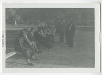
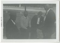
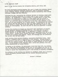
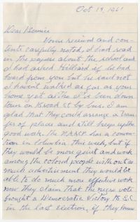
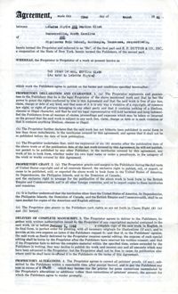
Correspondence from Bernice V. Robinson to the Highlander Staff regarding the Report of the Training Leaders for Citizenship Schools, July 17 to 23, 1961.
Transcriptions of Rabbi Padoll’s typewritten and handwritten sermons and addresses from his various rabbinates, including Charleston’s Kahal Kadosh Beth Elohim. A civil rights advocate, Padoll discusses ongoing struggles for social justice, contemporary events such as the assassination of Robert F. Kennedy, and parables related to the Sabbath and holiday celebrations. Padoll stored his sermons in nine binders, and the transcriptions reflect this original order. Burton L. Padoll (1929-2004), was born to Leah and Charles Padoll in Canton, Ohio. Padoll attended the Hebrew Union College in Cincinnati, Ohio, where he was ordained in 1957 and received an honorary Doctorate of Divinity in 1982. After his ordination, Padoll served as assistant rabbi in Brookline, Massachusetts. In 1961, Padoll took a position as rabbi of Kahal Kadosh Beth Elohim (KKBE) in Charleston, South Carolina, where he served for six years. During this time, Padoll strongly advocated for civil rights and criticized Charleston's Jewish community for their failure to aid the struggle for racial equality. After leaving Charleston in 1967, Padoll moved to Peabody, Massachusetts, where he became the rabbi of Temple Beth Shalom in 1969 until his retirement in 1989. Padoll lived in Mount Jackson, Virginia, until his death in 2004.
Contract and Agreement between Septima P. Clark and LeGette Blythe regarding the publication of "The Story of Mrs. Septima Clark" through publisher E.P. Dutton and Co., In.
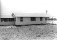
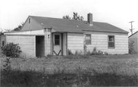
House (rear view) on site affected by the construction of Interstate 26 (I-26). [Building address number 145.] Surveyor notations on back of photo: "Dkt.: 10.480. Property owner: Jerome M. Williams. Tract: 270. Station: 5724+10 Lt. (Line C). Date: May 31, 1961. Proximity." [See collection description for explanation of surveyor notations.]
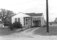
House on site affected by the construction of Interstate 26 (I-26). Possibly on Rivers Avenue. Surveyor notations on back of photo: "Dkt.: 10.486. Property owner: Ernest E. & Nolie C. Grooms. Williams Furniture Corp. Tract: 41. Station: 29+40 Lt. Date: May 30, 1961. In R/W - Bought." [See collection description for explanation of surveyor notations.]
House (corner view, rear) on site affected by the construction of Interstate 26 (I-26). Possibly on Rivers Avenue. Surveyor notations on back of photo: "Dkt.: 10.486. Property owner: Mrs. Mertice S. Greenhill. Tract: 26. Station: 8+50 Lt. (Line E). Date: May 30, 1961. In R/W - Bought." [See collection description for explanation of surveyor notations.]
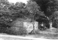
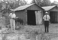
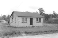
Shed on site affected by the construction of Interstate 26 (I-26). Surveyor notations on back of photo: "Dkt.: 10.480. Property owner: C.H. & Elise V. Meidburg. Tract: 249. Station: 5705+80 Lt. Date: May 31, 1961. In R/W - Bought." [See collection description for explanation of surveyor notations.]
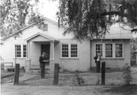
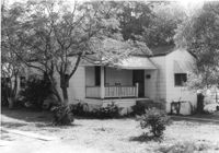
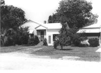
House (corner view, rear) on site affected by the construction of Interstate 26 (I-26). [Building address number 131). Surveyor notations on back of photo: "Dkt.: 10.480. Property owner: Minnie L. Geiger. Tract: 277. Station: 5725+40 Rt. (Line C). Date: May 31, 1961. In R/W - Bought." [See collection description for explanation of surveyor notations.]
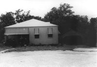
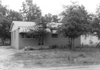
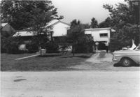
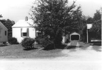
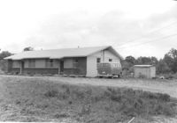
House on site affected by the construction of Interstate 26 (I-26). Building address number 4800. Possibly on Rivers Avenue. Surveyor notations on back of photo: "Dkt.: 10.486. Property owner: Redding F. Moore. Tract: 23, 24, 25. Station: 15+70 Lt. (Line C). Date: May 30, 1961. In R/W to be moved." [See collection description for explanation of surveyor notations.]
House on site affected by the construction of Interstate 26 (I-26). Building address number 131. Surveyor notations on back of photo: "Dkt.: 10.480. Property owner: Minnie L. Geiger. Tract: 277. Station: 5725+40 Rt. (Line C). Date: May 31, 1961. In R/W - Bought." [See collection description for explanation of surveyor notations.]
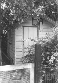
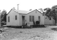
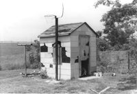
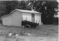
Guesthouse? on site affected by the construction of Interstate 26 (I-26). Surveyor notations on back of photo: "Dkt.: 10.480. Property owner: Jessie L. & Doris S. Bercaw. Tract: 272. Station: 5724+85 Rt. (Line C). Date: May 31, 1961. In R/W - Bought." [See collection description for explanation of surveyor notations.]
House on site affected by the construction of Interstate 26 (I-26). Surveyor notations on back of photo: "Dkt.: 10.480. Property owner: Mrs. Sarah Elise P. Ford Thompson. Tract: 260. Station: 5712+20 Lt. Date: May 31, 1961. In R/W - Bought." [See collection description for explanation of surveyor notations.]
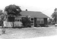
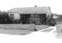
House on site affected by the construction of Interstate 26 (I-26). Surveyor notations on back of photo: "Dkt.: 10.480. Property owner: Rebecca R. Wiggins. Tract: 16. Station: 5503+30 Rt. Date: May 2, 1961. In R/W - Bought." [See collection description for explanation of surveyor notations.]
House on site affected by the construction of Interstate 26 (I-26). Surveyor notations on back of photo: "Dkt.: 10.480. Property owner: Central McMillan. Tract: 17. Station: 5503+70 Rt. Date: May 2, 1961. In R/W - Bought." [See collection description for explanation of surveyor notations.]
House on site affected by the construction of Interstate 26 (I-26). Surveyor notations on back of photo: "Dkt.: 10.480. Property owner: John Chaplin. Tract: 18. Station: 5503+90 Rt. Date: May 2, 1961. In R/W - Bought." [See collection description for explanation of surveyor notations.]
House on site affected by the construction of Interstate 26 (I-26). Surveyor notations on back of photo: "Dkt.: 10.480. Property owner: Paul Allen. Tract: 21. Station: 5503+80 Lt. Date: May 2, 1961. In R/W - Bought." [See collection description for explanation of surveyor notations.]
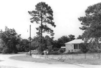
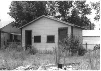
House on site affected by the construction of Interstate 26 (I-26). Building address number 107. Possibly on Rivers Avenue. Surveyor notations on back of photo: "Dkt.: 10.486. Property owner: G.F. & Beatrice C. Butler. Tract: 27. Station: 7+50 (Line E). Date: May 30, 1961. Proximity." [See collection description for explanation of surveyor notations.]
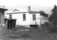
House (rear view) on site affected by the construction of Interstate 26 (I-26). Possibly on Rivers Avenue. Surveyor notations on back of photo: "Dkt.: 10.486. Property owner: M.V. & Beatrice Barrineau. Tract: 25-A. Station: 16+00 Rt. (Line C). Date: May 30, 1961. Bought." [See collection description for explanation of surveyor notations.]
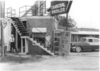
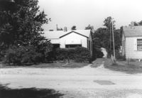
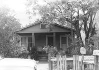
Restaurant building on site affected by the construction of Interstate 26 (I-26). Stairway and sign for Buffet Lunch in foreground. Portion of neon sign: Charcoal Broiler hangs over a phone booth. Possibly on Rivers Avenue. Surveyor notations on back of photo: "Dkt.: 10.486. Property owner: John Marcotsis, Trustee. Tract: 32. Station: 3+00 Rt. (Line F). Date: May 30, 1961. Steps to be moved. Proximity." [See collection description for explanation of surveyor notations.]
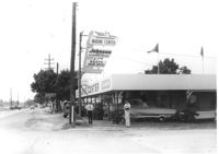
Marine Center (boat sales) on site affected by the construction of Interstate 26 (I-26). Address 4752 Rivers Avenue. View of street corner. C & R Motors in background. Possibly on Rivers Avenue. Surveyor notations on back of photo: "Dkt.: 10.486. Property owner: C.W. Keller. Tract: 33. Station: 2+75 Lt. (Line E). Date: May 30, 1961. Sign to be moved." [See collection description for explanation of surveyor notations.]
House on site affected by the construction of Interstate 26 (I-26). Neon sign for a Drive In (__MANER'S) (name partly illegible) in front, at right of photo. Possibly on Rivers Avenue. Surveyor notations on back of photo: "Dkt.: 10.486. Property owner: M.V. & Beatrice Barrineau. Tract: 25-A. Station: 16+00 Rt. (Line C). Date: May 30, 1961. Bought." [See collection description for explanation of surveyor notations.]
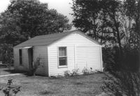
House (corner view, rear) on site affected by the construction of Interstate 26 (I-26). Surveyor notations on back of photo: "Dkt.: 10.480. Property owner: Willie M. Burbage. Tract: 271. Station: 5724+60 Lt. (Line C) Date: May 31, 1961. Proximity." [See collection description for explanation of surveyor notations.]
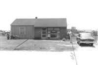
House/office (side view) on site affected by the construction of Interstate 26 (I-26). Signs "Open for Inspection" and posted office hours on front. Possibly on Rivers Avenue. Surveyor notations on back of photo: "Dkt.: 10.486. Property owner: Otis R. Burbage. Tract: 22 & 34. Station: 14+80 Rt. Date: May 30, 1961. In R/W to be moved." [See collection description for explanation of surveyor notations.]
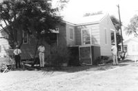
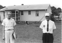
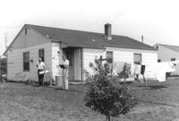
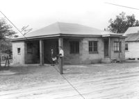
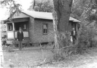
Rear view of house on site affected by the construction of Interstate 26 (I-26). Possibly on Rivers Avenue. Two DOT employees in foreground. Surveyor notations on back of photo: "Dkt.: 10.486. Property owner: Robert E. Holman. Tract: 35. Station: 11+50 Lt. (Line D). Date: May 30, 1961. Proximity." [See collection description for explanation of surveyor notations.]
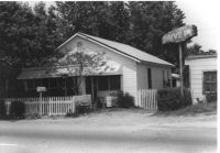
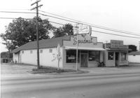
The Spudnut Shop [3646 Dorchester Road], on site affected by the construction of Interstate 26 (I-26). Front facade has stepped parapet. Neighboring building, Pick & Pay Grocery, also in photo. Surveyor notations on back of photo: "Dkt.: 10.480. Property owner: John C. Gelegotes, et al. Tract: 164. Station: 5681+50 on CL. Date: May 30, 1961. In R/W - Bought." [See collection description for explanation of surveyor notations.]
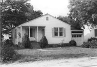
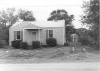
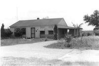
House on Dorchester Road, on site affected by the construction of Interstate 26 (I-26). Building address number 7. Surveyor notations on back of photo: "Dkt.: 10.480. Property owner: Fred M. Skipper. Tract: 179. Station: 132+90 Rt. (Route 642) [Dorchester Road]. Date: May 30, 1961. In R/W - Bought." [See collection description for explanation of surveyor notations.]
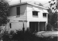
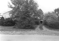
House on site affected by the construction of Interstate 26 (I-26). Partially obscured by trees. Garage (2-story) at end of driveway. Surveyor notations on back of photo: "Dkt.: 10.480. Property owner: Eugene J. Poteat. Tract: 201. Station: 5689+50 Lt. Date: May 31, 1961. In R/W - Bought." [See collection description for explanation of surveyor notations.]
House on Dorchester Road, on site affected by the construction of Interstate 26 (I-26). Building address number 7. Surveyor notations on back of photo: "Dkt.: 10.480. Property owner: Fred M. Skipper. Tract: 179. Station: 132+90 Rt. (Route 642) [Dorchester Road]. Date: May 30, 1961. In R/W - Bought." [See collection description for explanation of surveyor notations.]
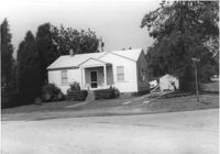
House at curve in road, on site affected by the construction of Interstate 26 (I-26). Surveyor notations on back of photo: "Dkt.: 10.480. Property owner: Mrs. Hazel McSherley Barton. Tract: 185. Station: 5684+65± Rt. (Line D). Date: May 31, 1961. Damage to fence and loss of pine tree." [See collection description for explanation of surveyor notations.]
House on corner of Harvey Avenue, on site affected by the construction of Interstate 26 (I-26). Street sign for Harvey Ave. at right. Surveyor notations on back of photo: "Dkt.: 10.480. Property owner: Renkin Finance Co. Tract: 188. Station: 5686+00 Lt. Date: May 31, 1961. In R/W - Bought." [See collection description for explanation of surveyor notations.]
House on Dorchester Road, on site affected by the construction of Interstate 26 (I-26). Surveyor notations on back of photo: "Dkt.: 10.480. Property owner: Mrs. Margaret H. Patterson. Tract: 181. Station: 134+00 (Rt. (Route 642) [Dorchester Road]. Date: May 31, 1961. In R/W - Bought." [See collection description for explanation of surveyor notations.]
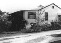
House on site affected by the construction of Interstate 26 (I-26). Partially obscured by trees. Surveyor notations on back of photo: "Dkt.: 10.480. Property owner: Sallie Mae Penninger. Tract: 198. Station: 5688+95 Lt. Date: May 31, 1961. In R/W - Bought." [See collection description for explanation of surveyor notations.]
Property and structure (shed?) on Dorchester Road, on site affected by the construction of Interstate 26 (I-26). Surveyor notations on back of photo: "Dkt.: 10.480. Property owner: Mrs. Dorothy V. Bartee. Tract: 178. Station: 132+42 Rt. (Route 642) [Dorchester Road]. Date: May 30, 1961. In R/W - Bought." [See collection description for explanation of surveyor notations.]
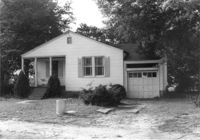
House on site affected by the construction of Interstate 26 (I-26). Building address number 191. Driveway leads to garage/shed. Surveyor notations on back of photo: "Dkt.: 10.480. Property owner: John S. Singleton. Tract: 132. Station: 5652+80 Rt. Date: May 1, 1961. In R/W - Bought." [See collection description for explanation of surveyor notations.]
House on site affected by the construction of Interstate 26 (I-26). Building address number 109. Surveyor notations on back of photo: "Dkt.: 10.480. Property owner: Tujax, Inc. Tract: 283. Station: 5732+70 Lt. (Line B). Date: May 30, 1961. In R/W - Bought." [See collection description for explanation of surveyor notations.]
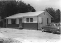
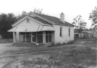
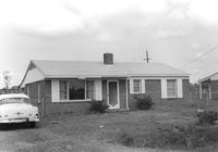
House on site affected by the construction of Interstate 26 (I-26). Building address number 209. Surveyor notations on back of photo: "Dkt.: 10.480. Property owner: Donald L. Gibson, et al. Tract: 141. Station: 5658+30 Rt. Date: May 2, 1961. In R/W - Bought." [See collection description for explanation of surveyor notations.]
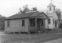
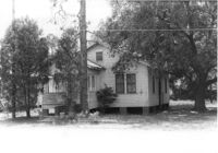
House on site affected by the construction of Interstate 26 (I-26). Neighboring church in background. Surveyor notations on back of photo: "Dkt.: 10.480. Property owner: Joseph Perry. Tract: 35. Station: 5507+40 Lt. Date: May 1, 1961. In R/W - Bought." [See collection description for explanation of surveyor notations.]
House (rear view) on site affected by the construction of Interstate 26 (I-26). Surveyor notations on back of photo: "Dkt.: 10.480. Property owner: Eugene J. Poteat. Tract: 201. Station: 5689+50 Lt. Date: May 31, 1961. In R/W - Bought." [See collection description for explanation of surveyor notations.]
House (rear view) on site affected by the construction of Interstate 26 (I-26). Surveyor notations on back of photo: "Dkt.: 10.480. Property owner: Joseph A. Elsey. Tract: 200. Station: 5689+70 Rt. Date: May 31, 1961. In R/W - Bought." [See collection description for explanation of surveyor notations.]
House on site affected by the construction of Interstate 26 (I-26). Surveyor notations on back of photo: "Dkt.: 10.480. Property owner: Crider O. Murray. Tract: 202. Station: 5689+90 Lt. Date: May 31, 1961. In R/W - Bought." [See collection description for explanation of surveyor notations.]
House on site affected by the construction of Interstate 26 (I-26). Surveyor notations on back of photo: "Dkt.: 10.480. Property owner: Joseph A. Elsey. Tract: 200. Station: 5689+70 Rt. Date: May 31, 1961. In R/W - Bought." [See collection description for explanation of surveyor notations.]
Two-story garage (corner view) on site affected by the construction of Interstate 26 (I-26). Surveyor notations on back of photo: "Dkt.: 10.480. Property owner: Eugene J. Poteat. Tract: 201. Station: 5689+50 Lt. Date: May 31, 1961. In R/W - Bought." [See collection description for explanation of surveyor notations.]
House on site affected by the construction of Interstate 26 (I-26). Possibly on Rivers Avenue. Surveyor notations on back of photo: "Dkt.: 10.486. Property owner: Hubert W. Keller. Tract: 29. Station: 6+80 (Line F). Date: May 30, 1961. Proximity." [See collection description for explanation of surveyor notations.]
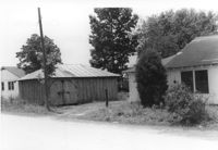
Storage shed on site affected by the construction of Interstate 26 (I-26). Possibly on Rivers Avenue. Surveyor notations on back of photo: "Dkt.: 10.486. Property owner: Ida K. Hill. Tract: 37. Station: 12+30 Lt. (Line D). Date: May 30, 1961. In R/W - Bought." [See collection description for explanation of surveyor notations.]
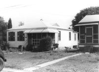
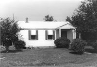
House (corner view, rear) on site affected by the construction of Interstate 26 (I-26). Building address number 18. Surveyor notations on back of photo: "Dkt.: 10.480. Property owner: Harry Morse Construction Co. Tract: 196. Station: 5688+00 Lt. Date: May 31, 1961. In R/W - Bought." [See collection description for explanation of surveyor notations.]
House (side view) on site affected by the construction of Interstate 26 (I-26). Partially obscured by trees. Surveyor notations on back of photo: "Dkt.: 10.480. Property owner: Sallie Mae Penninger. Tract: 198. Station: 5688+95 Lt. Date: May 31, 1961. In R/W - Bought." [See collection description for explanation of surveyor notations.]
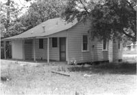
House on site affected by the construction of Interstate 26 (I-26). Garage/shed at end of driveway. Surveyor notations on back of photo: "Dkt.: 10.480. Property owner: Herbert Jones. Tract: 192. Station: 5687+00 Lt. Date: May 31, 1961. In R/W - Bought." [See collection description for explanation of surveyor notations.]
House on site affected by the construction of Interstate 26 (I-26). Neighboring (rear) houses and structures in background. Surveyor notations on back of photo: "Dkt.: 10.480. Property owner: Rochell Dinkins, et al. Tract: 59. Station: 5516+80 Lt. Date: May 1, 1961. In R/W - Bought." [See collection description for explanation of surveyor notations.]
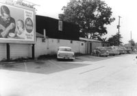
Dorchester Electric Service (side view) on site affected by the construction of Interstate 26 (I-26). Building address number 3640 [possibly Dorchester Road]. Billboard for Swift's Premium Meats for Babies on side of building. Surveyor notations on back of photo: "Dkt.: 10.480. Property owner: Laura B. Beaufort. Tract: 167. Station: 5681+40 Lt. Date: May 30, 1961. In R/W - Bought." [See collection description for explanation of surveyor notations.]
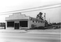
Terrace Market on site affected by the construction of Interstate 26 (I-26). Building is closed. Sunbeam Bread sign on side of building. Front facade has stepped parapet. Surveyor notations on back of photo: "Dkt.: 10.480. Property owner: John C. Gelegotes, et al. Tract: 163. Station: 5681+00 Rt. Date: May 30, 1961. In R/W - Bought." [See collection description for explanation of surveyor notations.]
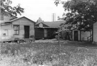
Rear view of dwellings and other structures on site affected by the construction of Interstate 26 (I-26). Sign for The Spudnut Shop in mid-background. Surveyor notations on back of photo: "Dkt.: 10.480. Property owner: Arlene Phillips, Est. Tract: 165. Station: 5680+75 Lt. Date: May 30, 1961. In R/W - Bought." [See collection description for explanation of surveyor notations.]
House (corner view, rear) on site affected by the construction of Interstate 26 (I-26). Building address number 33. Surveyor notations on back of photo: "Dkt.: 10.480. Property owner: Jesse L. Kennedy. Tract: 290. Station: 5738+85 Rt. (Line B). Date: May 30, 1961. In R/W - Bought." [See collection description for explanation of surveyor notations.]
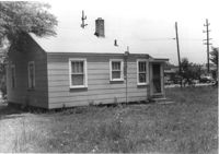
House (rear view) on site affected by the construction of Interstate 26 (I-26). Building address number 35. Surveyor notations on back of photo: "Dkt.: 10.480. Property owner: Mrs. Helen S. Shuler. Tract: 291. Station: 5738+50 CL. Date: May 30, 1961. In R/W - Bought." [See collection description for explanation of surveyor notations.]
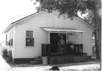
House on site affected by the construction of Interstate 26 (I-26). Building address number 35. Surveyor notations on back of photo: "Dkt.: 10.480. Property owner: Mrs. Helen S. Shuler. Tract: 291. Station: 5738+50 CL Main Line. Date: May 30, 1961. In R/W - Bought." [See collection description for explanation of surveyor notations.]
House (corner view, rear) on site affected by the construction of Interstate 26 (I-26). Surveyor notations on back of photo: "Dkt.: 10.480. Property owner: Mrs. Evelyn R. King. Tract: 288. Station: 5738+80 Lt. (Line B). Date: May 30, 1961. Proximity." [See collection description for explanation of surveyor notations.]
House on site affected by the construction of Interstate 26 (I-26). Surveyor notations on back of photo: "Dkt.: 10.480. Property owner: Mrs. Evelyn R. King. Tract: 288. Station: 5738+80 Lt. (Line B). Date: May 30, 1961. Proximity." [See collection description for explanation of surveyor notations.]
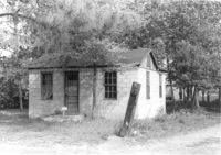
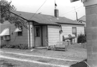
Small shed on site affected by the construction of Interstate 26 (I-26). Surveyor notations on back of photo: "Dkt.: 10.480. Property owner: Harold W. Cone. Tract: 285. Station: 5734+10 Lt. (Line B). Date: May 30, 1961. In R/W - Bought." [See collection description for explanation of surveyor notations.]
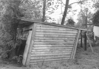
Shed on site affected by the construction of Interstate 26 (I-26). Surveyor notations on back of photo: "Dkt.: 10.480. Property owner: Ruth I. Kirby. Tract: 236. Station: 5699+30 Lt. Date: May 2, 1961. In R/W - Bought." [See collection description for explanation of surveyor notations.]
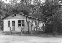
House on site affected by the construction of Interstate 26 (I-26). Sign over window: Pat's TV and Radio Repair. Surveyor notations on back of photo: "Dkt.: 10.480. Property owner: Boyd E. Patterson. Tract: 153. Station: 5666+80 Rt. Date: May 2, 1961. In R/W - Bought." [See collection description for explanation of surveyor notations.]
House on site affected by the construction of Interstate 26 (I-26). Obscured by trees. Garage/shed at end of driveway. Surveyor notations on back of photo: "Dkt.: 10.480. Property owner: Edward P. Blanton. Tract: 146. Station: 5661+30 Rt. Date: May 2, 1961. In R/W - Bought." [See collection description for explanation of surveyor notations.]
House on site affected by the construction of Interstate 26 (I-26). Building address number 105. Surveyor notations on back of photo: "Dkt.: 10.480. Property owner: Norman Lubesky. Tract: 284. Station: 5733+50 Lt. (Line B). Date: May 30, 1961. In R/W - Bought." [See collection description for explanation of surveyor notations.]
House on site affected by the construction of Interstate 26 (I-26). Royal Crown Cola sign on fence. Surveyor notations on back of photo: "Dkt.: 10.480. Property owner: Central McMillan, et al. Tract: 38. Station: 5508+40 Rt. Date: May 2, 1961. In R/W - Bought." [See collection description for explanation of surveyor notations.]
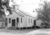
Enah Chapel Church on site affected by the construction of Interstate 26 (I-26). Surveyor notations on back of photo: "Dkt.: 10.480. Property owner: Enoch Methodist Church. Tract: 36. Station: 5507+80 Lt. Date: May 2, 1961. In R/W - Bought." [See collection description for explanation of surveyor notations.]
House on site affected by the construction of Interstate 26 (I-26). Surveyor notations on back of photo: "Dkt.: 10.480. Property owner: Joseph Perry. Tract: 34. Station: 5507+10 Lt. Date: May 2, 1961. In R/W - Bought." [See collection description for explanation of surveyor notations.]
House, possibly duplex, on site affected by the construction of Interstate 26 (I-26). Surveyor notations on back of photo: "Dkt.: 10.480. Property owner: Roy A. Farley, et al. Tract: 102-A. Station: 55+60 Lt. (Goodrich Road). Date: May 2, 1961. Proximity." [See collection description for explanation of surveyor notations.]
House on site affected by the construction of Interstate 26 (I-26). Outbuilding in background. Surveyor notations on back of photo: "Dkt.: 10.480. Property owner: Rosa Bell Harley. Tract: 83. Station: 5521+80 Rt. Date: May 2, 1961. In R/W - Bought." [See collection description for explanation of surveyor notations.]
House on site affected by the construction of Interstate 26 (I-26). Surveyor notations on back of photo: "Dkt.: 10.480. Property owner: Joe Stephens, Est. Tract: 29. Station: 5506+00 Lt. Date: May 1, 1961. In R/W - Bought." [See collection description for explanation of surveyor notations.]
House on site affected by the construction of Interstate 26 (I-26). Surveyor notations on back of photo: "Dkt.: 10.480. Property owner: Evelyn Nelson. Tract: 80. Station: 5519+30 Rt. Date: May 2, 1961. In R/W - Bought." [See collection description for explanation of surveyor notations.]
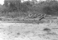
Pile of wood framing on lot, on site affected by the construction of Interstate 26 (I-26). Surveyor notations on back of photo: "Dkt.: 10.480. Property owner: Williams Furniture Co., et al. Tract: 103-B. Station: 5583+55 Rt. Date: May 2, 1961. In R/W - Bought." [See collection description for explanation of surveyor notations.]
House (rear view?) and structure (garage or shed) on site affected by the construction of Interstate 26 (I-26). Building address number 1800. Possibly on Rivers Avenue. Surveyor notations on back of photo: "Dkt.: 10.486. Property owner: G.P. Parris, Est. Tract: 6. Station: 9+50 Lt. Date: May 30, 1961. In R/W - Bought." [See collection description for explanation of surveyor notations.]
House (corner view, rear) on site affected by the construction of Interstate 26 (I-26). Building address number 1806. Possibly on Rivers Avenue. Surveyor notations on back of photo: "Dkt.: 10.486. Property owner: Cleve G. Murray. Tract: 12. Station: 10+90 Lt. Date: May 30, 1961. In R/W - Bought." [See collection description for explanation of surveyor notations.]
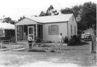
House on site affected by the construction of Interstate 26 (I-26). Piggly Wiggly store across the street, in background. Possibly on Rivers Avenue. Surveyor notations on back of photo: "Dkt.: 10.486. Property owner: Mrs. Hazel Faulkner. Tract: 9. Station: 10+35 Lt. Date: May 30, 1961. In R/W - Bought." [See collection description for explanation of surveyor notations.]
House on site affected by the construction of Interstate 26 (I-26). Surveyor notations on back of photo: "Dkt.: 10.480. Property owner: Herbert Jones. Tract: 192. Station: 5687+00 Lt. Date: May 31, 1961. In R/W - Bought." [See collection description for explanation of surveyor notations.]
Structure (storage shed/garage) on site affected by the construction of Interstate 26 (I-26). Possibly on Rivers Avenue. Surveyor notations on back of photo: "Dkt.: 10.486. Property owner: Otis R. Burbage. Tract: 22 & 34. Station: 14+80 Rt. Date: May 30, 1961. In R/W to be moved." [See collection description for explanation of surveyor notations.]
Outbuilding on site affected by the construction of Interstate 26 (I-26). Possibly on Rivers Avenue. Surveyor notations on back of photo: "Dkt.: 10.486. Property owner: Redding F. Moore. Tract: 23, 24, 25. Station: 15+90 Rt. (Line C). Date: May 30, 1961. In R/W - Bought." [See collection description for explanation of surveyor notations.]
House on site affected by the construction of Interstate 26 (I-26). Possibly on Rivers Avenue. Surveyor notations on back of photo: "Dkt.: 10.486. Property owner: Edward R. Livingston. Tract: 17. Station: 12+25 Lt. Date: May 30, 1961. In R/W - Bought." [See collection description for explanation of surveyor notations.]