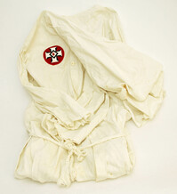
This forty-eight page academic student paper handwritten by C.C. Tseng provides an overview of slavery in ancient times, the modern world, and the United States. He describes the establishment of slavery in the United States, conditions of the enslaved lives, control of slaves, sale of slaves, and political and economic effects of slavery.
Department of the Interior Bureau of Education leaflet, "Civic Training Through Service," by Arthur William Dunn, Specialist in Civic Education for the United States Bureau of Education.
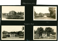
Photograph of group of three female Avery students posed in the grass outside of the Avery Institute. Two of the girls are identified as Gladys Jones and Annabele(?) Cox.
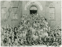
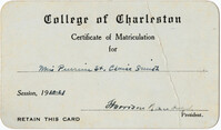
Clipping of article about 1920 graduation (Pierrine Smith [Byrd]'s freshman year). No formal excercises took place due to influenza outbreak earlier in the school year
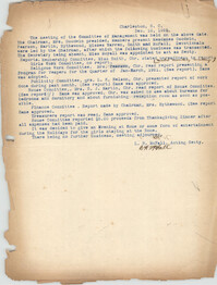
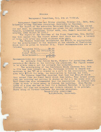
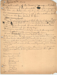
Correspondence from Walter B. Wilbur of Miller Huger, Wilbur and Miller Attorneys and Counsellors at Law to Ada C. Baytop regarding "the dissolution of the charter of the Colored Young Womens Christian Association."
The Direleton Plantation Memorandum Book was kept by James Ritchie Sparkman beginning in the 1850s; changes in handwriting indicate additional authors and additional uses into the 1900s. The book contains slave records. Records includes slave births, slave deaths, purchases of slaves, sales of slaves, family seperation, measurements for clothing, distribution of blankets, and labor tasks. The book also contains lists of first and last names of agricultural workers after the American Civil War and figures, likely wages paid. There are account records kept for purposes of the Internal Revenue Services, Confederate taxes and bonds, personal and agricultural work purchases, and financial transactions with B.M. Grier, Eliza S. Heriot, Dr. R.S. Heriot, A.G. Heriot (with signed receipts), M.E. Heriot (with signed receipts), and G.A. Thorne. There are transactions with other plantations recorded including Cornhill Plantation, Northampton Plantation, and Birdfield Plantation. There is information on livestock, wines removed from the plantation, and rice sales.
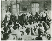
Photograph with inscription, "Mr. Benjamin Cox (Principal) standing at podium addressing weekly Chapel meeting. Mrs. Cox seated at extreme right. Miss Clyde (teacher) seated at left of Mr. Cox. Student body, faculty, principal B.F. Cox at podium in Avery Auditorium"
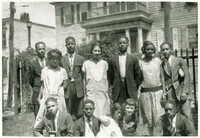
Photograph of group of twelve Averyites posed outside of the school. Caption: "Holloway, Lee, Richards became medical doctors (Back row second from left, Charles Holloway; fourth from left Arthur Lee; bottom right, Freddie Richards)."
In this four-page typed speech C.C. Tseng read to the Carolina Art Association in Charleston, South Carolina, he writes about Chinese landscape painting and its differences from Western art.
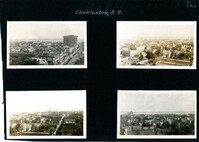
Four aerial views of Charleston looking across the peninsula. Top left: Looking northeast, possibly from St. Michael’s Church, showing Broad Street and the area to its north bounded by East Bay Street, and possibly Queen Street. Cars are parked along the street. Landmarks include the Confederate Home and its rear dormitory apartments, People's Building, Old Exchange Building, and the corner of Broad and Church Streets showing the Bank of South Carolina Building (50 Broad Street) before it was restored. A faint view of the U.S. Customhouse is at the far left. Top right: Looking southeast, possibly from the Francis Marion Hotel, with Meeting Street bisecting the view at a diagonal. Landmarks include the U.S. Customhouse, Charleston Hotel, People’s Building, and St. Philip’s Church. Bottom left: Looking south on King Street, possibly from the Francis Marion Hotel, showing King Street from approximately 360 King down to the bend near Market Street, and the view east of King Street. Vehicles can be seen on King Street. Landmarks include the Masonic Temple Building (270 King Street), the tower of the Peoples First National Bank Building (also known as the Hirsh Israel Building, 275 King Street), and the Hotel Calhoun (238-242 King Street). Bottom right: Looking southwest, possibly from St. Michael’s Church, toward James Island. Landmarks include the Fort Sumter House (1 King Street), Col. John Ashe House (32 South Battery), rear of First Scots Presbyterian Church (57 Meeting Street), Miles Brewton House (27 King Street), and the north elevation of the John E. Poyas House (69 Meeting Street).
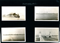
Four photographs on the page. Top left: Tugboat and other ships in a floating dry dock in the Charleston Harbor (possibly Charleston Shipbuilding). Top right: View of the Charleston waterfront from the Ashley River. Some of the landmark buildings visible in the background include St. Matthew's Church, Francis Marion Hotel, St. John's Lutheran Church, Unitarian Church, St. Philip's Church, People's Building, St. Michael's Church, and West Point Rice Mill. Bottom left: View of the Charleston waterfront from the Cooper River. Some of the landmark buildings visible in the background include Fort Sumter Hotel, St. Michael's Church, St. Philip's Church, U.S. Customhouse, and several wharves. Bottom right: Two cars on the Ashley River Bridge, one heading east and one heading west. View of the Charleston waterfront in the background.
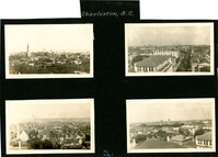
Four aerial views of Charleston looking across the peninsula. Top left: Looking northeast, possibly from City Hall. Landmarks include the rear dormitory apartments of the Confederate Home, St. Philip's Church, and the U.S. Customhouse. Top right: Looking north on Meeting Street, possibly from St. Michael’s Church, and showing the view west of Meeting Street. Vehicles, including a trolley car, can be seen on the street. Landmarks include the Timrod Hotel, Mills House Hotel, Fireproof Building, Circular Church, and Francis Marion Hotel (in the distance). Bottom left: Looking east on Calhoun Street, possibly from the Francis Marion Hotel, and showing the view east and west of Calhoun Street. Vehicles can be seen on the street. Landmarks include the Calhoun Monument in Marion Square, Citadel Square Baptist Church, and Emanuel A.M.E. Church. Bottom right: Looking north possibly from St. Michael’s Church. Landmarks include St. John's Lutheran Church, Unitarian Church, Grace Episcopal Church, and the Charleston Orphan House (in the distance at right).
Souvenir program for what appears to be a U.S. Navy event that occurred in Charleston during the Coolidge administration. Focuses on the U.S. Navy, with naval history and lists of ships and ship personnel, and historical information about the Charleston Navy Yard. Also provides Charleston history and information on various sites, including churches. Advertisements for local businesses, many of which are directed specifically to the Navy visitors, are interspersed throughout. [80] p., ill., 22 x 30 cm.
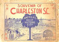
Guidebook to Charleston, containing a history of Charleston; descriptions of many points of interest; street guide; and map featuring ward boundaries and points of interest. Advertisements interspersed throughout. Published by Walker, Evans & Cogswell. 95 p. : ill., fold. map ; 20 cm.
Unidentified infant wearing a cap is sitting in rocking chair in front of 167 Congress Street. Inscription reads “A.B. Photo Finishers 'Always Busy' Mezzaine Giddens-Lane Bldg.”
One of three scrapbooks compiled by William Henry Johnson containing, among other materials, photographs depicting scenes of the South Carolina Lowcountry, with descriptive notes. Volume 1 includes photographs depicting cemeteries, churches, plantations, historic buildings, ruins, landscapes, and the interiors of buildings. Subjects include locations in Berkeley County, St. Johns (Berkeley) Parish, Goose Creek, and along the Cooper River. Other sites and subjects include Belmont, Black Oak Church, Bluford, Casada, Cedar Grove, Cedar Spring, Comingtee, a Prioleau family burial ground, Crowfield, Dean Hall Plantation, Dockon Plantation, Eutaw, Eutaw Springs, Exeter, Fairspring, Fort Dorchester, Four Hole Swamp, Gippy, Gravel Hill, the gravestone of Susan Bee, Hanover Plantation, Indian Fields Campground, Ingleside, Indianfield, Liberty Hall Club, Lewisfield, Magnolia Cemetery, monument of Col. Hezekiah Maham, grave of Major Majoribanks, Medway Plantation, Mepkin, a milestone by the Cooper River, Moorfield, Mount Pleasant Plantation, Mulberry Castle, North Hampton, Numertia, The Oaks Plantation, Ophir, Otranto Hunting Club, Parnassus, Pimlico, Pinegrove, Pond Bluff, Pooshee Plantation, John Poppenheim's plantation, Quarter house, Red Bank Hunting Club, an Episcopal church in Pineville, Rice Hope Plantation, The Rocks, St. James Goose Creek church, St. Johns Berkeley rectory site, St. Johns AME Church, a St. Julien family house, a Santee Canal lock, "Sarrazin house," a shanty, Somerset Plantation, Somerton Plantation, "Francis Marion spring," Springfield, Stoney Landing, Strawberry Chapel, Ten Mile Hill, Thoroughgood, Wadboo Barony, Wadboo bridge, Walnut Grove, Walworth, Wampee, Wampoolah, Wappetaw, Washington Plantation, the Whaley place, White Hall, Wiskinboo, Woodlawn, and Yeamans Hall.
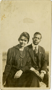
Miriam DeCosta Seabrook and Eugenia DeCosta Higgins are standing outside beside each other. Miriam is wearing a straw hat and light dress. Eugenia is wearing a short sleeve dress with ruffles.
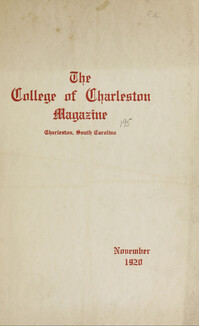
The College of Charleston Magazine is a monthly publication released by the College of Charleston's Chrestomathic Society during the academic year. This volume is comprised of the bound together publications from the months of November 1920-April 1921.
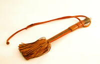
Knife contained in a leather sheath. There is a braided strap with a button loop closure and several decorative styles with a fringe at the base. Origin Liberia.
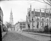
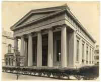
Photograph of the KKBE Synagogue taken by George W. Johnson in the mid-1920s. The back of the photograph includes a note stating the photo had been taken before the synagogue had air-conditioning.
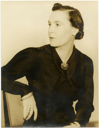
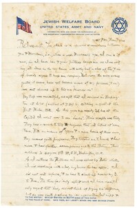
Incomplete letter to Jane L. Raisin from her husband, Jacob S. Raisin, commenting on the resemblance between Jane and their daughter, Mordenai. Raisin also discusses his travels, and visiting friends.