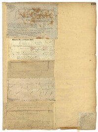
Page 119 of the City Engineer's Plat Book with five plats. Plat 1 shows land located between East Bay Street and the Cooper River. Plat 1 also shows Trott Street, Hasell Street, Concord Street, and Pinckney Street. Plat 2 features Bennett's Rice and Lumber Mills, near East Bay Street. Plat 3 features a plot on East Bay Street. Plat 4 features lots and structures located near Church Street and Market Street, and shows a lot labelled "Gas Company." Plat 5 shows lots located near the intersection of East Bay Street and Lodge Alley.
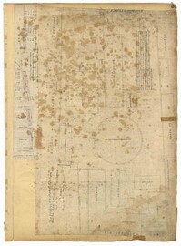
Page 59 of the City Engineer's Plat Book with two plats. Plat 1 shows lots on East Bay Street, between Pritchard Street and Rose Lane. Plat 2 shows a lot and buildings belonging to the Charleston Gas Light Company, located on Church Street.
Plat of a land containing ten acres, minimal detail showing the surrounding property owners and two roads; Dills Bluff and unnamed public road. Names associated with this plat are Plenty White, Simons and Howe. Notable geographic locations include Dill's Bluff.