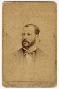
Typescript memoir entitled, "A Summary of the Principal Events of My Life," written by Philip Phillips, June 1870. Phillips' memoir includes early biographical information, his education, the beginnings and development of his career as a lawyer and eventually as a congressman, the Tariff Acts of 1828, the Missouri Compromise, the beginnings of the Civil War, and his wife's imprisonment in Washington D.C. and on Ship Island. The memoir also relates various experiences had by the Phillips family throughout the Civil War.
Meeting minutes volume kept by the Kahal Kadosh Beth Elohim Board of Trustees, 1866-1875. The entries in this volume concern all synagogue business, finances, membership, and plans of the amalgamation between the KKBE and Shearith Israel congregations. This volume also includes entries from 1863 regarding destruction caused in the midst of the Civil War.
Letter to trustees J.C.H. Claussen, G.W. Steffens and B. Bollmann from John Phillips, which encloses the title to the land on which the German Evangelical Lutheran Church- St. Matthew's Lutheran Church- is being constructed.
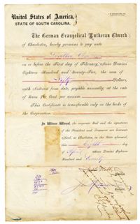
Document detailing the raising of $20,000 to complete the construction of St. Matthew's Lutheran Church- here under its original name, the German Evangelical Lutheran Church- through the mortgage of the church's land and sale of bonds, with the lot's mortgaged deed to be held by trustees J.C.H. Claussen, G.W. Steffens and B. Bollmann, and signed by John A. Wagener.
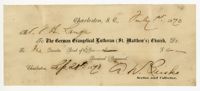
Bond document by St. Matthew's Lutheran Church- then known as the German Evangelical Lutheran Church- promising to repay Dorothea Clausen $50 by February 1, 1875, at 7% interest. Signed by President J.H. Kalb and secretary John Heeseman.
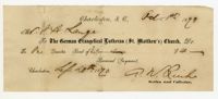
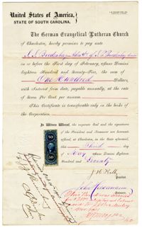
Bond document by St. Matthew's Lutheran Church- then known as the German Evangelical Lutheran Church- promising to repay J.J. Bredenberg $100 by February 1, 1875, at 7% interest. Signed by church president J.H. Kalb and secretary John Heeseman.
Letter from Joseph H. M. Chumaciero, KKBE minister, to the Board of Trustees regarding the pending visit of Reverend Dr. Isaac Mayer Wise to Charleston.
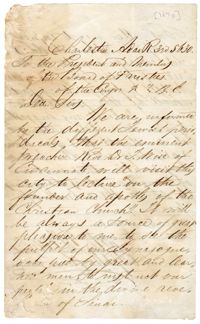
A note on the state of the congregation's membership numbers, finances, and property as a result of "the ravages of war." The note discusses the beginnings of the union with the Shearith Israel congregation (spelled here as "Sherit"). This note was written in connection with the KKBE Meeting Minutes Book dated 1866-1875.
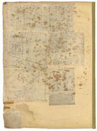
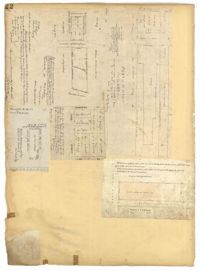
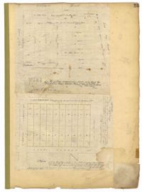
Page 48 of the City Engineer's Plat Book with five plats. Plat 1 shows lots located between Smith Street and King Street, and Radcliffe Street and Vanderhorst Street, including stretches of Thomas Street, Coming Street, St. Philip Street, and King Street. Plat 2 shows lots and buildings located near the intersection of King Street and South Bay Street. Plat 3 shows land near the intersection between Congress Street and Legare Street, and includes stretches of Hayne Street, Mount Street, and President Street. Plat 3 also shows some land labelled "City Land Potters Field." Plat 4 shows lots and a set of buildings located near Broad Street and Savage Street. Plat 5 shows lots and some buildings located on Gadsden Street.
Page 4 of the City Engineer's Plat Book with seven plats. Plat 1 features East Bay Street, Pinckney Street, Concord Street, and lots labelled "Burnt District." Plat 2 features lots on King Street. Plat 3 shows several lots on East Bay Street near the intersections with Pritchard Street and Hard Alley. Plat 4 shows three lots on East Bay Street. Plat 5 features lots at the intersection of East Bay Street and Hasell Street. Plat 5 shows a stretch of Queen Street including the intersections with Archdale Street and Friend Street, and includes a plat labelled "Catholic Church." Plat 7 shows plots of land on the intersection of Tradd Street and Meeting Street.
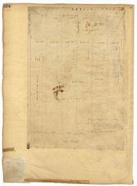
Page 205 of the City Engineer's Plat Book with two plats. Plat 1 shows "Lots in the Village of Rikersville," and shows Mechanics Street, 21 acres of marsh, a building labelled "Car Factory," a building labelled "Machinery," a building labelled "Wheat Mill," a canal, and a pond. Plat 2 shows lots and structures located between Pinckney Street and Market Street. Plat 2 also shows Hayne Street, Guignard Street, Church Street, Anson Street, Rafer's Alley, East Bay Street, a building labelled "Cotton Press," a park, and a building labelled "The Market."
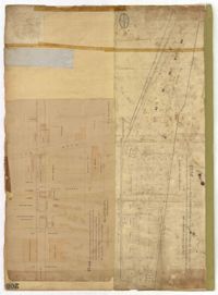
Page 63 of the City Engineer's Plat Book with five plats. Plat 1 features wharves located near East Bay Street, and shows several docks and buildings. Plat 2 shows wharfs shows a wharf and several buildings located near East Bay Street. Plat 3 features a wharf located near East Bay Street and shows multiple buildings and docks. Plat 4 features a wharf located between East Bay Street and the Cooper River channel, and also shows several buildings. Plat 5 shows lots located on and near Market Street, between East Bay and Concord Street. Plat 6 features a wharf located between East Bay Street and the Cooper River, and also shows several buildings.
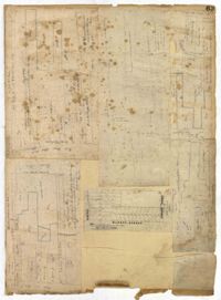
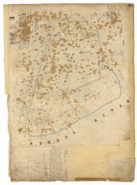
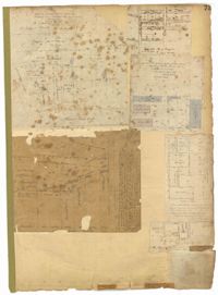
Page 67 of the City Engineer's Plat Book with two plats. Plat 1 features three lots located on Meeting Street, with stores and yards labelled. Plat 2 shows a stretch of land near the Ashley River, and the intersection of Calhoun and Lucas Street. Plat 2 also shows a large building labelled "West Point Rice Mill" and a stretch labelled "Mill Pond."
Page 22 of the City Engineer's Plat Book with five plats. Plat 1 shows lots located near the Charleston Harbor, Concord Street, Pinckney Street, and Pritchard Street. Plat 2 shows lots and structures located near the intersection of Concord Street and Pinckney Street, including a single-story building, a wharf, and a label reading "City property leased." Plat 3 shows a lot on Broad Street labelled "Lot of David McCredie." Plat 4 Shows lots located near Park Street, and between Shepherd Street and Line Street. Plat 5 shows lots near the intersection of Broad Street and Gadsden's Alley labelled with the names of banks.
Page 124 of the City Engineer's Plat Book with one plat. The plat features several lots and structures located on and near King Street, with one labelled "Theatre Lot."
Page 73 of the City Engineer's Plat Book with six plats. Plat 1 shows lots and some buildings located near the intersection of Chapel Street and Alexander Street. Plat 2 shows lots located near King Street's intersections with Radcliffe Street, Vanderhorst Street, Hutson Street, John Street, and Ann Street. The plat also shows Meeting Street, the Mall, and a body of water. Plat 3 shows lots, structures, and marshland located near the intersection of Coming Street and Smith Street. Plat 4 shows lots and some buildings located near John Street, between King Street and a some "Rail Road Land." Plat 5 shows lots located near King Street, between Tobacco Street and Calhoun Street. Plat 6 features a stretch of land between King Street and Meeting Street, along John Street's north side and near Radcliffe Street. The plat also shows a feature labelled "Ravine."
Page 27 of the City Engineer's Plat Book with five plats. Plat 1 shows lots located on Broad Street, between the intersections with East Bay Street and State Street. Plat 2 shows lots on Chapel Street. Plat 3 shows lots near Savage Street and Tradd Street. Plat 4 shows lots on Savage Street. Plat 5 shows lots near the intersection of Broad Street and East Bay Street.
Page 25 of the City Engineer's Plat Book with two plats. Plat 1 shows lots and buildings near Guignard Street, located between East Bay Street and "Rapers Ally." Plat 2 shows lots located near Cumming Street, between Shepherd Street and Line Street.