A Conveyance of property for $4,000 to Mrs. Annie Boyd Glover from Charles Darby, Catherine Lowndes Darby and James Lowndes Brisbane. The property is situated on the east side of Legare Street in ward number two in Charleston.
Notice of a bill sent to James B. Heyward from C.W. [Enecks?] at Wolfe Hill. Enecks mentions threshing wheat for Heyward and asks him where he should send it. 1p. June 11, 1868.
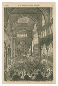
Black-and-white offset print reproduction of the interior of the former location of Temple Emanu-El at 5th Avenue and 43rd Street in New York, on the occasion of its dedication. Published in the October 8, 1868, edition of Frank Leslie's Illustrated Newspaper.
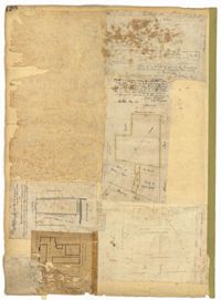
Page 120 of the City Engineer's Plat Book with five plats, labelled two through six. Plat 2 shows lots and buildings located near Cumberland Street, between Church Street and Philadelphia Street. Plat 3 shows lots located near the intersection Pinckney Street and Anson Street. Plat 4 shows lots and structures located on Hasell Street. Plat 5 shows lots and buildings along East Bay Street. Plat 6 shows lots and structures located between wharf street and the Cooper River.
Page 13 of the City Engineer's Plat Book with five plats. Plat 1 features plots on East Bay Street between Tradd Street and Broad Street (which is labelled in the top-left corner), including several wharfs. Plat 2 shows lots located between Archdale Street and King Street, including a plot belonging to the "German Lutheran Church." Plat 3 features a plot of land located on King Street. Plat 4 shows plots located on State Street between Market Street and Amen Street. Plat 5 features "Potters Field Public Cemetery," located near President Street and Congress Street.
Diary of Magdalen Elizabeth Wilkinson Keith for the years 1868-1870. Concerns mostly life at home, and family life. Mentions a solar eclipse [Aug. 1868], teaching at the Normal school and the subjugation of women
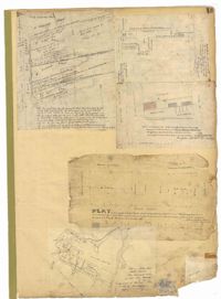
Page 28 of the City Engineer's Plat Book with three plats. Plat 1 shows lots located near Calhoun Street, Bull Street, South Street, Ashley Street, Rutledge Street Lynch Street, and Bennett Street. Plat 1 also shows lots labelled "The Mall," and Lots Belonging to Sundry Persons. Plat 2 shows lots and buildings located near the intersection of Calhoun Street and Lucas Street, including lots labelled "Mansion Lot" and "Left for a Public Square." Plat 3 shows lots and buildings located near Bee Street, between Ashley Street and Rutledge Street.
Page 5 of the City Engineer's Plat Book with three plats. Plat 1 shows plots near Meeting Street, Russell Street, King Street, and a creek labelled "Small Creek." Plat 2 shows plots of land near the intersection of Water Street and Church Street. Plat 3 shows Calhoun Street where it intersects with Ashley Street and Lynch Street, and shows a lot labeled "St. Xavier's Infirmary."