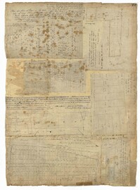
Page 77 of the City Engineer's Plat Book with seven plats, labelled 1 through 8 with Plat 3 missing. Plat 1 shows lots located between Smith Street and King Street, and between Morris Street and Radcliffe Street. Plat 1 also shows Coming Street and St. Philips Street, and a label reading "Bethlohim Congregation." Plat 2 shows lots and some structures near the intersection of King Street and Warren Street. Plat 4 shows lots between Smith Street and King Street, and north of Radcliffe Street. Plat 4 also shows Coming Street, St. Philips Street, Morris Street, and a lot labelled "Bethlehem Congregation." Plat 5 shows lots located near the intersection of Morris Street and St. Philips Street. Plat 6 shows lots located between Morris Street and "Hunter St now Line," and east of Coming Street. Plat 8 features a lot and structures located on the corner of St. Philips Street and Morris Street.
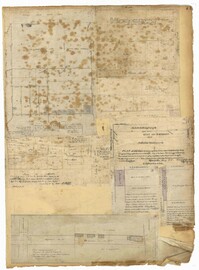
Page 71 of the City Engineer's Plat Book with eight plats. Plat 1 shows lots and structures on a city block between Rutledge Street and Smith Street, and between Beaufain Street and Wentworth Street. Plat 2 shows lots located near the intersection of Moore Street and Meeting Street. Plat 3 shows lots and structures located near the intersection of King Street and Beaufain Street. Plat 4 shows lots and structures located on the east side of Coming Street. Plat 5 shows lots located on King Street, including a lot labelled "Unitarian Church property" and a stretch labelled "Unitarian Church Cemetery." Plat 6 shows lots located on King Street, and shows the "Old line of street." Plat 7 shows plots located on King Street. Plat 8 features a lot and buildings located on Spring Street, and shows how Rosemont Street is projected to cross that property.
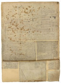
Page 75 of the City Engineer's Plat Book with six plats. Plat 1 features lots located between Radcliffe Street and Calhoun Street, and between Smith Street and Rutledge Street. Plat 1 also shows Vanderhorst Street, Thomas Street, and Warren Street. Plat 2 shows lots located near Morris Street, between St. Philips Street and Coming Street. Plat 3 shows lots located near the intersection of Morris Street and Coming Street, including a lot labelled "Cemetery" and another lot labelled "Hebrew Cemetery." Plat 4 shows land located near Thomas Street, between Doughty Street and Hutson Street, and also labels a pond. Plat 5 shows lots located between Pine Street and Gadsden Creek. Plat 6 shows lots and some buildings located between Pinckney Street and Smith Street.
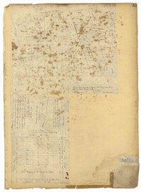
Page 43 of the City Engineer's Plat Book with two plats. Plat 1 shows lots near Jasper Street, Smith Street, Marion Street, and Radcliffe Street. Plat 2 shows lots between Back Street and Marsh Street, and Magazine Street and Queen Street.
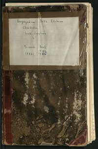
Meeting minutes volume kept by the Kahal Kadosh Beth Elohim Board of Trustees, 1846-1852. The entries in this volume concern all discussions regarding synagogue business, finances, memberships, the search for a new minister, and the beginnings of Reform Judaism within the congregation. The entries also include notes on Reverend Gustavus Poznanski and his thoughts on the Reform.
Meeting minutes volume kept by the Kahal Kadosh Beth Elohim Board of Trustees, 1857-1866. The entries in this volume concern all synagogue business, finances, membership, alterations regarding seating within the synagogue, the organ, and the choir. This volume also covers discussions regarding the amalgamation of the KKBE and Shearith Israel congregations in Charleston, S.C.
1850-1859, 1840-1849, 1830-1839, 1810-1819, and 1820-1829
Description:
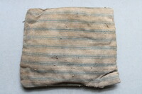
A small pillow, hand sewn with faded mattress ticking and stuffed with lambswool, uncovered during 2020 investigations of the Nathaniel Russell Kitchen House. Pillow was discovered under the floorboards in the front of the fireplace in the west enslaved quarter. Pillow measures 4"x5".
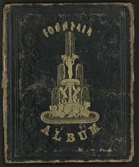
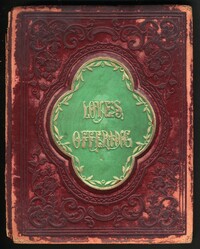
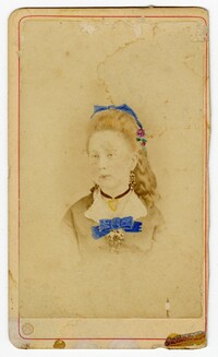
Album belonging to Rachel H. Levy. The album includes various newspaper clippings, handwritten poems by Levy and others, as well as handwritten notes from friends and family members.
Album belonging to Elizabeth J. Levy. The album includes various newspaper clippings, handwritten poems by Levy and others, as well as handwritten notes from friends and family members.
1850-1859, 1840-1849, 1830-1839, 1810-1819, and 1820-1829
Description:
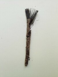
A small wooden brush with fine hairs uncovered during 2020 investigations of Nathaniel Russell House Kitchen House. Brush discovered under the floorboards in the front of the fireplace in the east enslaved quarter. Dates to period of enslavement.
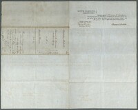
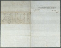
"Title of Real Estate" with covenants from Edward R. Laurens, Master in Equity, to Charles Dunn through auction for $1180 for the west side of King Street across from Citadel Square.
1850-1859, 1840-1849, 1830-1839, 1810-1819, and 1820-1829
Description:
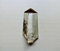
A fragmented crystal discovered during 2019 investigations of the Russell House Kitchen House. The crystal was wedged tightly between the end of an original floorboard and the first period masonry wall in the east enslaved quarter of the Russell House Kitchen House. One end identifies it as a chandelier or girandole crystal. The other end, however, shows evidence of a percussive strike, evidence it was intentionally struck one or more times to shape it into a crude point.
"Title of Real Estate" from Edward R. Laurens, Master in Equity, to Patrick O'Neill through auction for $2000 for the west side of King Street across from Citadel Square containing two lots.
1850-1859, 1870-1879, 1860-1869, 1840-1849, 1830-1839, and 1820-1829
Description:
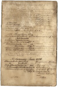
This is the plantation register by Mathurin Guerin Gibbs (1788-1849) for Rice Hope Plantation (January 1, 1824 to December 1844) and Jericho Plantation (December 1844 to 1875). Gibbs, a lawyer before becoming a planter, used the first several pages of the manuscript dating January 1824 to May 1829 for summarizing legal cases. The plantation register primarily documents daily labor activities on the plantation including cultivation and harvesting of staple crops such as corn, cotton (Sea Island Cotton and Santee black seed cotton), rice and potatoes, livestock, and building fences. Gibbes also writes about the use and management of slave labor, the movement of enslaved people between the plantation and Charleston, and selling and purchasing of enslaved people. Slave names are included in portions of the register. Gibbs notes throughout the register the struggles he encounters as a planter including being unable to pay the mortgage of Rice Hope Plantation and the property going into foreclosure. Most of the entries at the end of the register are regarding slave births, slave deaths and distribution of blankets. Gibbs died in 1849 and the management of the plantation was carried out by his son.