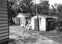
Sheds behind house on site affected by the widening of U.S. Route 17. Presumably located in Mount Pleasant or vicinity. Surveyor notations on back of photo: "Dkt.: 10.597. Property owner: Julia B. Simmons. Tract: 54. Station: 301±30 Lt. Date: Sept. 17, 1968." [See collection description for explanation of surveyor notations.]
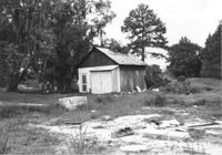
Shed and/or garage on site affected by the widening of U.S. Route 17. Presumably located in southern Charleston County. Surveyor notations on back of photo: "Dkt.: 10.600. Property owner: Vernon A. Ellis. Tract: 3. Station: 512± - 514± Rt. Date: Sept. 18, 1968." [See collection description for explanation of surveyor notations.]