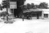
Clint's Place - Variety Store, corner of Craig Road, on site affected by the widening of State Road 13 (Remount Road). View of street corner. Surveyor notations on back of photo: "Dkt.: 10.562. Property owner: Samuel C. Rollings. Tract: 10. Date: Jul. 12, 1967." [See collection description for explanation of surveyor notations.]
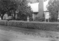
House on site affected by the widening of State Road 13 (Remount Road). Surveyor notations on back of photo: "Dkt.: 10.562. Property owner: Harry R. Parkinson, et al. Tract: 61. Date: Jul. 19, 1967." [See collection description for explanation of surveyor notations.]
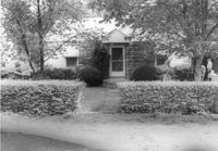
House on site affected by the widening of State Road 13 (Remount Road). 1552 Remount Road. Surveyor notations on back of photo: "Dkt.: 10.562. Property owner: Robert W. Kimbel. Tract: 60. Date: Jul. 19, 1967." [See collection description for explanation of surveyor notations.]
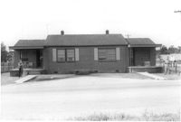
House on site affected by the widening of State Road 13 (Remount Road). Surveyor notations on back of photo: "Dkt.: 10.562. Property owner: Leonella Padgett. Tract: 148. Date: Jul. 19, 1967." [See collection description for explanation of surveyor notations.]
Site (affected by the widening of State Road 13 (Remount Road). Surveyor notations on back of photo: "Dkt.: 10.562. Property owner: West Virginia Pulp and Paper Co. Tract: 129. Date: Jul. 19, 1967." [See collection description for explanation of surveyor notations.]
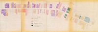
One of four maps of King Street building footprints, hand-colored to designate status. This map illustrates the historical significance of buildings on King Street from Calhoun Street to Queen Street.
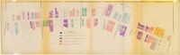
One of four maps of King Street building footprints, hand-colored to designate status. This map illustrates proposed reuses of buildings on King Street from Calhoun Street to Queen Street.
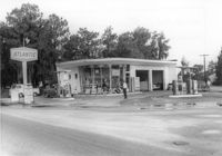
Atlantic gas station, on site affected by the widening of State Road 13 (Remount Road). Surveyor notations on back of photo: "Dkt.: 10.562. Property owner: Atlantic Refining Co. Tract: 37. Date: Jul. 19, 1967." [See collection description for explanation of surveyor notations.]
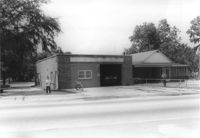
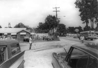
North Charleston Fire Department Station: No. 3, on site affected by the widening of State Road 13 (Remount Road). Trailer park in background. Surveyor notations on back of photo: "Dkt.: 10.562. Property owner: North Charleston Public Service. Tract: 6. Date: Jul. 12, 1967." [See collection description for explanation of surveyor notations.]
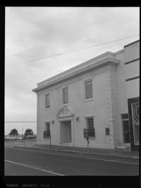
Office building with sign for Joe Grooms State Farm Insurance, on site affected by the widening of State Road 13 (Remount Road). Surveyor notations on back of photo: "Dkt.: 10.562. Property owner: Joseph J. Grooms. Tract: 18. Date: Jul. 12, 1967." [See collection description for explanation of surveyor notations.]
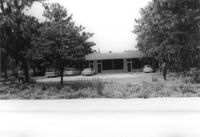
Office building on site affected by the widening of State Road 13 (Remount Road). Surveyor notations on back of photo: "Dkt.: 10.562. Property owner: Joseph J. Grooms. Tract: 18. Date: Jul. 12, 1967." [See collection description for explanation of surveyor notations.]
Handwritten correspondence from Mrs. Joseph King to Mrs. John C. Hawk and Mrs. Russell D. Long, President and Executive Director of the Coming Street Y.W.C.A., regarding Advisory Committee matters.
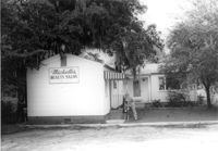
Michelle's Beauty Salon, on site affected by the widening of State Road 13 (Remount Road). Surveyor notations on back of photo: "Dkt.: 10.562. Property owner: Jerry Gray. Tract: 120. Date: Jul. 19, 1967." [See collection description for explanation of surveyor notations.]
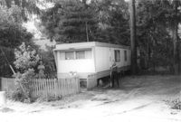
Mobile home on site affected by the widening of State Road 13 (Remount Road). Surveyor notations on back of photo: "Dkt.: 10.562. Property owner: Alline S. Crum. Tract: 139. Date: Jul. 19, 1967." [See collection description for explanation of surveyor notations.]
Four B&W photographs of buildings on the east side of King Street: Top left (368-370): 368 King Street (Club 400) (demolished for parking lot) and 270 King Street (World Finance Corp.); Top right: 362-364 King Street (Kaybee); Bottom left (354-356): 354 King Street and 356 King Street (White House Grocery); Bottom right (344-348): 344 King Street (Clark Clothier), 346 King Street, and 348 King Street (American Arcade - American Mortgage Co.)
Four B&W photographs of buildings on the west side of King Street, including 213 King and 215 King, demolished for the construction of Majestic Square: Top left (211-215): 211-213 King (Palmetto Hotel) and 215 King Street (Stephan's); Top right: 197 King Street; Bottom left 193-197: 193 King Street (Colonial Antique Shop), 195 King Street, and 197 King Street; Bottom right (191-197): 191 King Street (Birlant Antiques), 193 King Street, 195 King Street, 197 King Street.
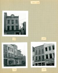
Three B&W photographs of buildings on the west side of King Street, demolished for the construction of Majestic Square: Top left: 223 King Street (Ocean Grill); Top right: 221 King Street (photograph is missing); Bottom left (219-223): 219 King Street (Rice Bros.), 221 King Street, and 223 King Street (Ocean Grill); Bottom right (217-219): 217 King Street and 219 King Street (Rice Bros.).
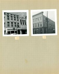
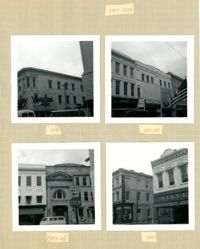
Two B&W photographs of buildings on the east side of King Street, both demolished for the construction of Charleston Place: Left (224-226): 224 King Street and 226 King Street (Ritz Hotel); Right: 222 King Street (Copa Lounge) (northeast corner of King and Market).
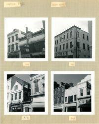
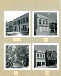
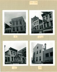
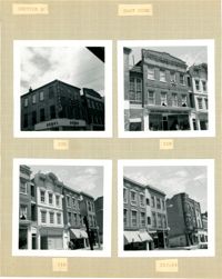
Four B&W photographs of buildings on the east side of King Street: Top left (178-184): 178 King Street (W.K. Prause Co.), 180 King Street, 182 King Street, and 184 King Street; Top right: 174 King Street; Bottom left: 164 King Street (Charleston Library Society) [labeled 168 on album page]; Bottom right (160-162): 160 King Street and 162 King Street.
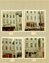
Four color photographs of buildings on the west side of King Street: Top left: 235 King Street (Interiors); Top right: 233 King Street; Bottom left: 231 King Street (The Tiki); Bottom right: 229 King Street (Old Towne Restaurant)
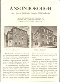
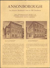
Second revision of six-page brochure includes background information on the Ansonborough Rehabilitation Project and Revolving Fund, photographs and information about Ansonborough homes, and a map of Ansonborough. Notes indicate which listed homes have been sold.
Second revision of six-page brochure includes background information on the Ansonborough Rehabilitation Project and Revolving Fund, photographs and information about Ansonborough homes, and a map of Ansonborough. Notes indicate which listed homes have been sold.
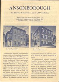
First revision of six-page brochure includes background information on the Ansonborough Rehabilitation Project and Revolving Fund, photographs and information about Ansonborough homes, and a map of Ansonborough. Notes indicate which listed homes have been sold.
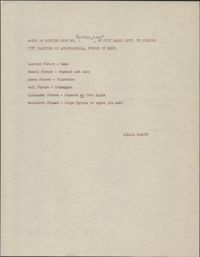
This one-page typed document lists several streets in Ansonborough alongside types of trees. These notes are from Alicia Rudolf's meeting with a Mr. Burroughs of the City Parks Department in the summer of 1967.
Three B&W photographs and one color photograph of buildings on the west side of King Street: Top left (319-325): 319 King Street (Bob Ellis Shoe Store), 321 King Street, 323 King Street (LeRoy's Jewelry Co.), and 325 King Street (Thom McAn); Top right: 315 King Street (Jean Meyers); Bottom left: 309-311 King Street (color photograph); Bottom right: 297 King Street (National Shirt Shop) (Arcade Theater sign on corner of building).
Four B&W photographs of buildings on the west side of King Street: Top left: 381 King Street (Felder's Rexall Drugs); Top right (367-369): 367 (Convertino's One Hour Cleaning) and 369 King Street (Lesser's Credit Jewelers); Bottom left (369-371): 369 King Street (Lesser's Credit Jewelers) and upper left portion of 371 King Street; Bottom right (341-343): 341 King Street (C.W. Kessler's) and 343 King Street (Askew's Clothiers).
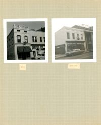
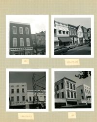
Two B&W photographs of buildings on the west side of King Street: Left (159-161): 159 King Street (Hildebrands) and 161 King Street; Right (201-203): 201 King Street (Castanes Grocery) and 203 King Street (later demolished for the construction of Victoria Center).
Four B&W photographs of buildings on the west side of King Street: Top left: 273 King Street (Mary Jane Shoe Store); Top right (263-267): 263 King Street (Legerton's), 265 King Street (Scottie Stores), and 267 King Street (Warner's); Bottom left (251-253): 251 King Street (Adams and Ortmann) and -253 King Street; Bottom right (243-245): 243 King Street (Siegling's) and 245 King Street (Silver 5 & 10 & 1.00 Store).
Four B&W photographs of buildings on the east side of King Street: Top left (188-200): 188 King Street (Installment Finance Co. Loans), 190 King Street, and 192-200 King Street (Hoffman House); Top right (188-190): Edge of 188 King Street (Installment Finance Co. Loans) and 190 King Street (Home Appliances and Service Co.); Bottom left: 188 King Street (Installment Finance Co.); Bottom right (184-186): 184 King Street (Dinty Moore's) and 186 King Street.
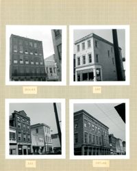
Four B&W photographs of buildings on the east side of King Street: Top left: 220 King Street (Dumas); Top right: 218 King Street (Sharnoff's Uniform Shop); Bottom left (212-218): 212 King Street, 214 King Street (Fabric Center), 216 King Street, and edge of 218 King Street; Bottom right (208-214): 208 King Street (Gatlin Opticians), 212 King Street (La Scaltro Antiques), and 214 King Street (Fabric Center).
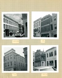
Four B&W photographs of buildings on the west side of King Street: Top left (181-183): 181 King Street (Jack Patla Antiques) and 183 King Street (The Art Shop); Top right (175-179): 175 King Street, 177 King Street, and 179 King Street (Fralix & Sons); Bottom left (169-173): 169 King Street (R.M. McGillivray's) and 171-173 King Street; Bottom right (165-169); 165 King Street and 169 King Street (R.M. McGillivray's).
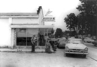
Arrow Restaurant, on site affected by the widening of State Road 13 (Remount Road). Surveyor notations on back of photo: "Dkt.: 10.562. Property owner: F.L. Parks, Jr. Tract: 3. Date: Jul. 12, 1967." [See collection description for explanation of surveyor notations.]
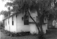
House on site affected by the widening of State Road 13 (Remount Road). Rear view. Surveyor notations on back of photo: "Dkt.: 10.562. Property owner: Charles R. Roberson. Tract: 36-A. Date: Jul. 19, 1967." [See collection description for explanation of surveyor notations.]
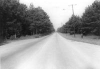
Site affected by the widening of State Road 13 (Remount Road). Surveyor notations on back of photo: "Dkt.: 10.562. Property owner: F.L. Parks, Jr. Tract: 3. Date: Jul. 12, 1967." [See collection description for explanation of surveyor notations.]