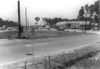
Esso Service Station: at intersection of Orange Grove Road and SC Highway 7 (Sam Rittenberg Boulevard), on site affected by the widening of Routes 7 & 171. Surveyor notations on back of photo: "Dkt.: 10.551. Property owner: Humble Oil Co. Tract: 1. Station: 36±00 Rt. Date: Jul. 22, 1965. West from east side Orange Grove Rd. of range poles on corners of ? area. [See collection description for explanation of surveyor notations.]
Student Nonviolent Coordinating Committee mimeo report entitled, "Life With Lyndon In The Great Society," Vol. 1, No. 5 "by Jack Minnis criticizing governmental policy under President Lyndon B. Johnson."
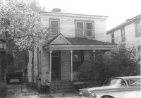
House on site affected by the construction of Interstate 26 (I-26). Address: 5 Carolina Street. Surveyor notations on back of photo: "Dkt.: 10.517. Property owner: I.S. Keith Ellsworth, Sr. Tract: 128. Station: 22+00 Rt. (Line "1"). Date: November 4, 1965. Front and side view of residence and property entirely in R/W." [See collection description for explanation of surveyor notations.]
House on site affected by the construction of Interstate 26 (I-26). Address: 5 Carolina Street. Surveyor notations on back of photo: "Dkt.: 10.517. Property owner: I.S. Keith Ellsworth, Sr. Tract: 128. Station: 22+00 Rt. (Line "1"). Date: November 4, 1965. View of subject building and lot entirely in R/W." [See collection description for explanation of surveyor notations.]
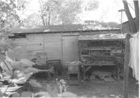
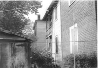
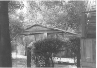
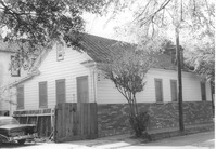
Shed behind house on site affected by the construction of Interstate 26 (I-26). Address: 5 Carolina Street. Surveyor notations on back of photo: "Dkt.: 10.517. Property owner: I.S. Keith Ellsworth, Sr. Tract: 128. Station: 22+50 Rt. (Line "1"). Date: November 4, 1965. Backyard with shed, entirely in R/W." [See collection description for explanation of surveyor notations.]
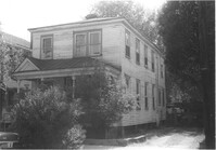
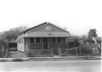
House on site affected by the construction of Interstate 26 (I-26). Address: 3 Carolina Street. Surveyor notations on back of photo: "Dkt.: 10.517. Property owner: Benjamin J. Finklea. Tract: 129. Station: 21+65 Rt. (Line "1"). Date: November 4, 1965. Subject residence and lot entirely in R/W." [See collection description for explanation of surveyor notations.]
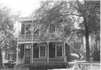
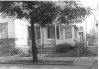
House on site affected by the construction of Interstate 26 (I-26). Address: 3 Carolina Street. Surveyor notations on back of photo: "Dkt.: 10.517. Property owner: Benjamin J. Finklea. Tract: 129. Station: 21+65 Rt. (Line "1"). Date: November 4, 1965. Front view of subject residence entirely in R/W." [See collection description for explanation of surveyor notations.]
House (rear) on site affected by the construction of Interstate 26 (I-26). Address: 3 Carolina Street. Surveyor notations on back of photo: "Dkt.: 10.517. Property owner: Benjamin J. Finklea. Tract: 129. Station: 21+65 Rt. (Line "1"). Date: November 4, 1965. Rear view of subject property and building entirely in R/W." [See collection description for explanation of surveyor notations.]
House on site affected by the construction of Interstate 26 (I-26). Address: 1 Carolina Street. Surveyor notations on back of photo: "Dkt.: 10.517. Property owner: Ella W. Britton. Tract: 130. Station: 21+30 Lt. and Rt. (Line "1"). Date: November 4, 1965. Front view of residence and lot entirely in R/W." [See collection description for explanation of surveyor notations.]
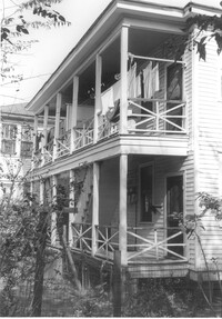
House (side view, rear) on site affected by the construction of Interstate 26 (I-26). Address: 1 Carolina Street. Surveyor notations on back of photo: "Dkt.: 10.517. Property owner: Ella W. Britton. Tract: 130. Station: 21+30 Lt. and Rt. (Line "1"). Date: November 4, 1965. Side and rear view of residence and lot, all entirely in R/W." [See collection description for explanation of surveyor notations.]
Garage behind house on site affected by the construction of Interstate 26 (I-26). Address: 1 Carolina Street. Surveyor notations on back of photo: "Dkt.: 10.517. Property owner: I.S. Keith Ellsworth, Sr. Tract: 128. Station: 22+50 Rt. (Line "1"). Date: November 4, 1965. Garage entirely in R/W." [See collection description for explanation of surveyor notations.]
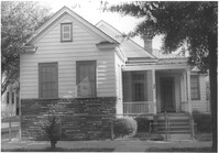
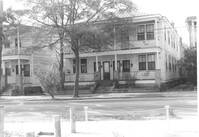
House on site affected by the construction of Interstate 26 (I-26). Address: 310 St. Philip Street. Surveyor notations on back of photo: "Dkt.: 10.517. Property owner: Benjamin W. Steed. Tract: 131. Station: 20+65 Lt. and Rt. (Line "1"). Date: November 4, 1965. Front view of subject residence and lot, all in R/W." [See collection description for explanation of surveyor notations.]
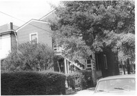
House on site affected by the construction of Interstate 26 (I-26). Address: 310 St. Philip Street. Surveyor notations on back of photo: "Dkt.: 10.517. Property owner: Benjamin W. Steed. Tract: 131. Station: 20+65 Lt. and Rt. (Line "1"). Date: November 4, 1965. Side view of residence entirely in R/W." [See collection description for explanation of surveyor notations.]
House on site affected by the construction of Interstate 26 (I-26). Address: 310 St. Philip Street. View of street corner; corner of St. Philip Street and Carolina Street. Surveyor notations on back of photo: "Dkt.: 10.517. Property owner: Benjamin W. Steed. Tract: 131. Station: 20+50 Lt. and Rt. (Line "1"). Date: November 4, 1965. Side view of residence in R/W." [See collection description for explanation of surveyor notations.]
House (rear and side view) on site affected by the construction of Interstate 26 (I-26). Address: 310 St. Philip Street. Surveyor notations on back of photo: "Dkt.: 10.517. Property owner: Benjamin W. Steed. Tract: 131. Station: 20+10 Lt. and Rt. (Line "1"). Date: November 4, 1965. Rear view of residence and lot all in R/W." [See collection description for explanation of surveyor notations.]
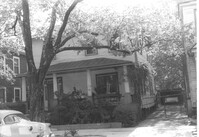
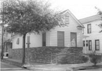
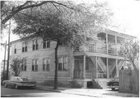
House on site affected by the construction of Interstate 26 (I-26). Address: 693 King Street. Surveyor notations on back of photo: "Dkt.: 10.517. Property owner: Rose Sokol. Tract: 132. Station: 19+20 Lt. and Rt. (Line "1"). Date: November 4, 1965. Front view of subject residence and lot, all in R/W." [See collection description for explanation of surveyor notations.]
House (corner view, rear) on site affected by the construction of Interstate 26 (I-26). Address: 693 King Street. Surveyor notations on back of photo: "Dkt.: 10.517. Property owner: Rose Sokol. Tract: 132. Station: 19+85 Lt. and Rt. (Line "1"). Date: November 4, 1965. Rear view of residence. Complete lot and building in R/W." [See collection description for explanation of surveyor notations.]
House on site affected by the construction of Interstate 26 (I-26). Address: 691 King Street. Surveyor notations on back of photo: "Dkt.: 10.517. Property owner: Henry Deas Jr., et al. Tract: 133. Station: 18+60 Rt. (Line "1"). Date: November 4, 1965. Front view of subject residence showing portion in R/W. Range poles on new R/W." [See collection description for explanation of surveyor notations.]
House (rear) on site affected by the construction of Interstate 26 (I-26). Address: 691 King Street. Surveyor notations on back of photo: "Dkt.: 10.517. Property owner: Henry Deas Jr., et al. Tract: 133. Station: 18+60 Rt. (Line "1"). Date: November 4, 1965. Rear view of subject residence. Not in R/W. Range poles on new R/W." [See collection description for explanation of surveyor notations.]
House, likely on Spruill Avenue, on site affected by the construction of Interstate 26 (I-26). Surveyor notations on back of photo: "Dkt.: 10.490. Property owner: Ellen Hartfield, Estate. Tract: 2. Station: 46+15 Rt. (Spruill Ave.). Date: November 4, 1965. Range poles on new R/W. Proximity." [See collection description for explanation of surveyor notations.]