Shed on site affected by the construction of the Crosstown. Address: 118 Sheppard Street. Surveyor notations on back of photo: "Dkt.: 10.524. Property owner: John H. Jenkins. Tract: 143. Station: 18+60 Lt. S.B. lane. Date: Dec. 2, 1964. Outside R/W." [See collection description for explanation of surveyor notations.]
Shed on site affected by the construction of the Crosstown. Address: 116 Sheppard Street. Surveyor notations on back of photo: "Dkt.: 10.524. Property owner: Margaret Oree. Tract: 144. Station: 18+95 Lt. S.B. lane. Date: Dec. 2, 1964. Outside R/W." [See collection description for explanation of surveyor notations.]
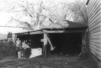
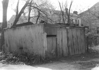
Garage and shed on site affected by the construction of the Crosstown. Address: 504 Rutledge Avenue. Surveyor notations on back of photo: "Dkt.: 10.524. Property owner: Florence Britton Jones. Tract: 114. Station: 87±00 Rt. Date: Dec. 1, 1964. In R/W - Bought." [See collection description for explanation of surveyor notations.]
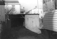
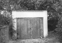
Shed or garage on site affected by the construction of the Crosstown. Address: 287 Coming Street. Surveyor notations on back of photo: "Dkt.: 10.524. Property owner: John T. Bowden. Tract: 152. Station: 21+10 Lt. S.B. lane. Date: Dec. 2, 1964. In R/W - Bought." [See collection description for explanation of surveyor notations.]
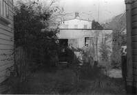
Shed, on site affected by the construction of the Crosstown. Address: 259 Ashley Avenue. Surveyor notations on back of photo: "Dkt.: 10.524. Property owner: Madeline H. LaRoache, et al. Tract: 76. Station: 77+90 Rt. Date: Oct. 14, 1964. In R/W - Bought." [See collection description for explanation of surveyor notations.]
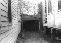
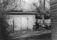
Garage and/or shed on site affected by the construction of the Crosstown. Address: 106 Sheppard Street. Surveyor notations on back of photo: "Dkt.: 10.524. Property owner: Annie H. Powers. Tract: 149. Station: 20+70 Lt. S.B. lane. Date: Dec. 2, 1964. In R/W - Bought." [See collection description for explanation of surveyor notations.]
Shed on site affected by the construction of the Crosstown. Address: 119 Sheppard Street. Surveyor notations on back of photo: "Dkt.: 10.524. Property owner: Scott M. Boyle. Tract: 139. Station: 17+25 Rt. N.B. lane. Date: Dec. 2, 1964. Outside R/W." [See collection description for explanation of surveyor notations.]