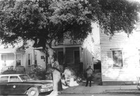
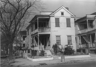
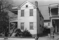
House on site affected by the construction of the Crosstown. Address: 504 Rutledge Avenue. Surveyor notations on back of photo: "Dkt.: 10.524. Property owner: Florence Britton Jones. Tract: 114. Station: 86+30 Rt. Date: Dec. 1, 1964. In R/W - Bought." [See collection description for explanation of surveyor notations.]
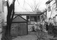
Storage shed or garage and backyard in rear of house on site affected by the construction of the Crosstown. Address: 160½ Line Street [160 Line Street]. Surveyor notations on back of photo: "Dkt.: 10.524. Property owner: John Meyer, Est. Tract: 101. Station: 83+65 Lt. Date: Dec. 1, 1964. In R/W - Bought." [See collection description for explanation of surveyor notations.]
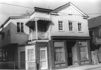
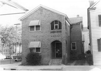
House on site affected by the construction of the Crosstown. Address: 158 Line Street. First story appears to be a store (or office) front. Signs for W.L. Metz, Jr. and H.L. Davis in window. Surveyor notations on back of photo: "Dkt.: 10.524. Property owner: William A. Williams. Tract: 102. Station: 83+70 CL. Date: Dec. 1, 1964. In R/W - Bought. [See collection description for explanation of surveyor notations.]
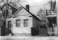
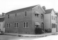
House (freedman's cottage) on site affected by the construction of the Crosstown. Address: 162½ Line Street [162 Line Street]. Surveyor notations on back of photo: "Dkt.: 10.524. Property owner: Frederick J. Cook. Tract: 99. Station: 82+65 Lt. Date: Dec. 1, 1964. In R/W - Bought." [See collection description for explanation of surveyor notations.]
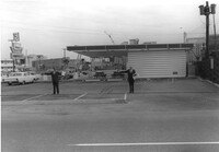
Hardee's (side view), on site affected by the construction of the Crosstown. Address: 223 Spring Street. Surveyor notations on back of photo: "Dkt.: 10.524. Property owner: Sarah Chinnis Sanders. Tract: 157. Station: 14+60 Rt. Spring Street. Date: Dec. 2, 1964." [See collection description for explanation of surveyor notations.]
House on site affected by the construction of the Crosstown. Address: 16 Todd Street. View of street corner (corner of Todd Street and Sheppard Street). Surveyor notations on back of photo: "Dkt.: 10.524. Property owner: Wilmot J. Frasier. Tract: 125. Station: 88+80 Lt. Date: Dec. 2, 1964. In R/W - Bought." [See collection description for explanation of surveyor notations.]
House on site affected by the construction of the Crosstown. Address: 16 Todd Street. View of street corner (corner of Todd Street and Sheppard Street). Surveyor notations on back of photo: "Dkt.: 10.524. Property owner: Wilmot J. Frasier. Tract: 125. Station: 88+80 Lt. Date: Dec. 2, 1964. In R/W - Bought." [See collection description for explanation of surveyor notations.]
House on site affected by the construction of the Crosstown. Address: 120 Sheppard Street. View of street corner. Surveyor notations on back of photo: "Dkt.: 10.524. Property owner: Jackson T. Rhodes. Tract: 142. Station: 18+25 Lt. S.B. lane. Date: Dec. 2, 1964. Condemned." [See collection description for explanation of surveyor notations.]
House on site affected by the construction of the Crosstown. Address: 506 Rutledge Avenue. Surveyor notations on back of photo: "Dkt.: 10.524. Property owner: Stephen B. Graham, et al. Tract: 113. Station: 86+50 Lt. Date: Dec. 1, 1964. In R/W - Bought." [See collection description for explanation of surveyor notations.]
House on site affected by the construction of the Crosstown. Address: 120 Sheppard Street. Surveyor notations on back of photo: "Dkt.: 10.524. Property owner: Jackson T. Rhodes. Tract: 142. Station: 18+25 Lt. S.B. lane. Date: Dec. 2, 1964. Condemned." [See collection description for explanation of surveyor notations.]