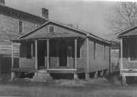
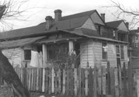
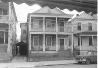
House on site affected by the construction of Interstate 26 (I-26). Address: 109½ Romney Street [109 Romney Street]. Surveyor notations on back of photo: "Dkt.: 10.503. Property owner: Mary C. Banks. Tract: 90. Station: 5917+70 Rt. Date: Feb. 20, 1963. In R/W - Bought." [See collection description for explanation of surveyor notations.]
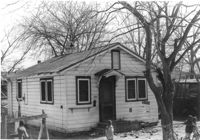
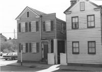
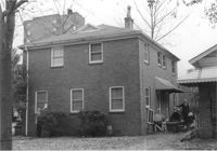
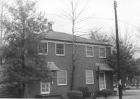
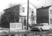
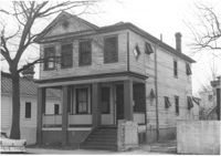
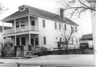
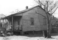
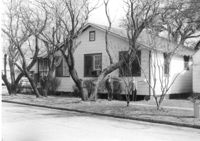
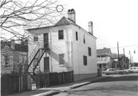
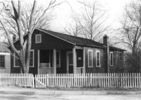
House on site affected by the construction of Interstate 26 (I-26). Address: 104 Romney Street. Surveyor notations on back of photo: "Dkt.: 10.503. Property owner: Sidney Goff. Tract: 87. Station: 5915+80 Lt. Date: Feb. 20, 1963. In R/W - Bought." [See collection description for explanation of surveyor notations.]
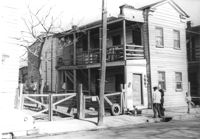
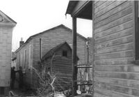
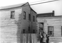
Houses (rear view) on site affected by the construction of the Crosstown. Address: 85 Lee Street. Surveyor notations on back of photo: "Dkt.: 10.518. Property owner: Joe S. Brown, et al. Tract: 2. Station: 38+90 Lt. S.B. lane Route 17. Date: Mar. 6, 1963. In R/W - Bought. [See collection description for explanation of surveyor notations.]
House on site affected by the construction of the Crosstown. Address: 85 Lee Street. Surveyor notations on back of photo: "Dkt.: 10.518. Property owner: Joe S. Brown, et al. Tract: 2. Station: 38+90 Lt. S.B. lane Route 17. Date: Mar. 6, 1963. In R/W - Bought. [See collection description for explanation of surveyor notations.]
Houses on site affected by the construction of the Crosstown. Address: 81 Lee Street. Surveyor notations on back of photo: "Dkt.: 10.518. Property owner: William H. Stevens. Tract: 4. Station: 39+40 Lt. S.B. lane Route 17. Date: Mar. 6, 1963. In R/W - Bought. [See collection description for explanation of surveyor notations.]
Houses on site affected by the construction of the Crosstown. Address: 83 Lee Street. Surveyor notations on back of photo: "Dkt.: 10.518. Property owner: Simon Sumter. Tract: 3. Station: 39+15 Lt. S.B. lane Route 17. Date: Mar. 6, 1963. In R/W - Bought. [See collection description for explanation of surveyor notations.]
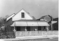
Building, on site affected by the construction of the Crosstown. Address: 80 Cooper Street. Front facade has stepped parapet. Surveyor notations on back of photo: "Dkt.: 10.518. Property owner: Helen Phillips Brown. Tract: 9. Station: 38+95 Rt. N.B. lane Route 17. Date: Mar. 6, 1963. In R/W - Bought. [See collection description for explanation of surveyor notations.]
Portion of house (rear view) on site affected by the construction of Interstate 26 (I-26). Address: 6 Maple Street. Surveyor notations on back of photo: "Dkt.: 10.503. Property owner: Atlantic Coast Life Ins. Co., et al. Tract: 49. Station: 5906+25 Lt. on CL. Date: Feb. 19, 1963. In R/W - Bought." [See collection description for explanation of surveyor notations.]
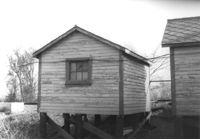
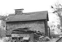
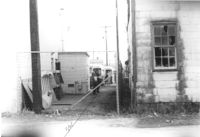
Rear view of shed (railroad building) on site affected by the construction of Interstate 26 (I-26). Address: 19½ Poinsett Street (rear). Surveyor notations on back of photo: "Dkt.: 10.503. Property owner: S.A.L.R.R. Tract: 105. Station: 5924+40 Rt. & Lt. Date: Feb. 20, 1963." [See collection description for explanation of surveyor notations.]
Rear view of shed (railroad building) on site affected by the construction of Interstate 26 (I-26). Address: 19½ Poinsett Street (rear). Surveyor notations on back of photo: "Dkt.: 10.503. Property owner: S.A.L.R.R. Tract: 105. Station: 5924+40 Lt. Date: Feb. 20, 1963." [See collection description for explanation of surveyor notations.]
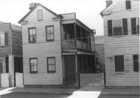
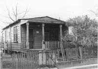
House on site affected by the construction of Interstate 26 (I-26). Address: 17 Addison Street. Surveyor notations on back of photo: "Dkt.: 10.503. Property owner: Violet Chapman. Tract: 99. Station: 5919+90 Lt. Date: Feb. 20, 1963. In R/W - Bought." [See collection description for explanation of surveyor notations.]
Building on site affected by the construction of Interstate 26 (I-26). Address: 15½ Addison Street (rear) [15 Addison Street]. Surveyor notations on back of photo: "Dkt.: 10.503. Property owner: Evan Gethers, et al. Tract: 100. Station: 5920+45 Lt. Date: Feb. 20, 1963. In R/W - Bought." [See collection description for explanation of surveyor notations.]
House (rear view) on site affected by the construction of Interstate 26 (I-26). Address: 5 D Street. Surveyor notations on back of photo: "Dkt.: 10.517. Property owner: James H. Anderson, et al. Tract: 18. Station: 5945+90 Lt. - Line 1. Date: February 21, 1963. In R/W - Bought." [See collection description for explanation of surveyor notations.]
House (rear view) on site affected by the construction of Interstate 26 (I-26). Address: 7A D Street. Surveyor notations on back of photo: "Dkt.: 10.517. Property owner: Hattie Bell Collier Jones. Tract: 17. Station: 5945+65 Lt. - Line 1. Date: February 21, 1963. In R/W - Bought." [See collection description for explanation of surveyor notations.]
House (side view) on site affected by the construction of Interstate 26 (I-26). Address: 7 D Street. Surveyor notations on back of photo: "Dkt.: 10.517. Property owner: Rebecca Finklestein. Tract: 16. Station: 5945+45 Lt. - Line 1. Date: February 21, 1963. In R/W - Bought." [See collection description for explanation of surveyor notations.]
House on site affected by the construction of Interstate 26 (I-26). Address: 5 D Street. Surveyor notations on back of photo: "Dkt.: 10.517. Property owner: James H. Anderson, et al. Tract: 18. Station: 5945+90 Lt. - Line 1. Date: February 21, 1963. In R/W - Bought." [See collection description for explanation of surveyor notations.]
House on site affected by the construction of Interstate 26 (I-26). Address: 7A D Street. Surveyor notations on back of photo: "Dkt.: 10.517. Property owner: Hattie Bell Collier Jones. Tract: 17. Station: 5945+65 Lt. - Line 1. Date: February 21, 1963. In R/W - Bought." [See collection description for explanation of surveyor notations.]
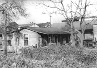
Dwelling (rear view) on site affected by the construction of Interstate 26 (I-26). Address: 39-43 Mount Pleasant Street. Surveyor notations on back of photo: "Dkt.: 10.503. Property owner: Joyce L. Darby, et al. Tract: 3. Station: 5891+00 Rt. Date: Feb. 19, 1963. Portion in R/W to be removed." [See collection description for explanation of surveyor notations.]
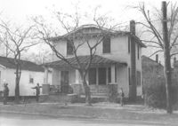
House on site affected by the construction of Interstate 26 (I-26). Address: 12 Lenox Street. Joseph Floyd Manor (Mount Pleasant Street and King Street) in background. Surveyor notations on back of photo: "Dkt.: 10.503. Property owner: Harry Thompson. Tract: 38. Station: 5901+50 Lt. Date: Feb. 19, 1963. In R/W - Bought." [See collection description for explanation of surveyor notations.]
House (rear view) on site affected by the construction of Interstate 26 (I-26). Waverly Novels, Tales of a Grandfather; being stories taken from Scottish history, 2nd series in 2 volumes, vol. I. 160 Laurel Avenue. Surveyor notations on back of photo: "Dkt.: 10.503. Property owner: Joseph A. Pippin. Tract: 8. Station: 5894+40 Rt. Date: Feb. 19, 1963. In R/W - Bought." [See collection description for explanation of surveyor notations.]
House (rear view) on site affected by the construction of Interstate 26 (I-26). Address: 15 Indian Street. Surveyor notations on back of photo: "Dkt.: 10.503. Property owner: Anaconda Ltd. Tract: 77. Station: 5913+40 Lt. Date: Feb. 20, 1963. In R/W - Bought." [See collection description for explanation of surveyor notations.]
House on site affected by the construction of Interstate 26 (I-26). Address: 702 Indian Street. Surveyor notations on back of photo: "Dkt.: 10.503. Property owner: Harold I. Sherman. Tract: 73. Station: 5912+50 Rt. Date: Feb. 20, 1963. In R/W - Bought." [See collection description for explanation of surveyor notations.]
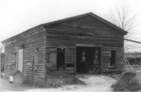
Side view of commercial building with 6 bays (garage?) on site affected by the construction of Interstate 26 (I-26). Address: 739 Meeting Street. Surveyor notations on back of photo: "Dkt.: 10.503. Property owner: Alton M. Silver. Tract: 58. Station: 5908+15 Lt. Date: Feb. 20, 1963. In R/W - Bought." [See collection description for explanation of surveyor notations.]
Commercial building with 6 bays (garage?) on site affected by the construction of Interstate 26 (I-26). Address: 739 Meeting Street. Surveyor notations on back of photo: "Dkt.: 10.503. Property owner: Alton M. Silver. Tract: 58. Station: 5908+15 Lt. Date: Feb. 20, 1963. In R/W - Bought." [See collection description for explanation of surveyor notations.]
House (corner view, rear) on site affected by the construction of Interstate 26 (I-26).Address: 169 Laurel Avenue. Joseph Floyd Manor (Mount Pleasant Street and King Street) in background. Surveyor notations on back of photo: "Dkt.: 10.503. Property owner: Ernestine L. Captain. Tract: 5. Station: 5892+10 Rt. Date: Feb. 19, 1963. In R/W - Bought." [See collection description for explanation of surveyor notations.]
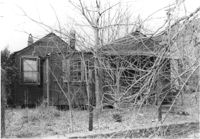
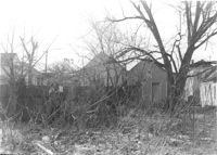
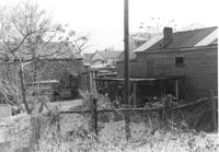
Backyard area and neighboring houses on site affected by the construction of Interstate 26 (I-26). Address: Laurel Avenue (?). Surveyor notations on back of photo: "Dkt.: 10.503. Property owner: Francis D. Guzzell. Tract: 7. Station: 5894+55 Rt. Date: Feb. 19, 1963. Proximity." [See collection description for explanation of surveyor notations.]
Dwelling on site affected by the construction of Interstate 26 (I-26). Address: 39-43 Mount Pleasant Street. Appears to be a duplex. Surveyor notations on back of photo: "Dkt.: 10.503. Property owner: Joyce L. Darby, et al. Tract: 3. Station: 5891+00 Rt. Date: Feb. 19, 1963. Portion in R/W to be removed." [See collection description for explanation of surveyor notations.]
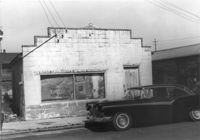
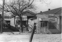
M&F Food Store on site affected by the construction of Interstate 26 (I-26). Address: 14 D Street. Surveyor notations on back of photo: "Dkt.: 10.517. Property owner: Frank Lea. Tract: 13. Station: 5944+55 Rt. - Line 6. Date: February 21, 1963. In R/W - Bought." [See collection description for explanation of surveyor notations.]
House on site affected by the construction of the Crosstown. Address: 120 America Street. Surveyor notations on back of photo: "Dkt.: 10.518. Property owner: Geraldine M. Henry. Tract: 62. Station: 50+70 Rt. N.B. lane Route 17. Date: Mar. 7, 1963. In R/W - Bought." [See collection description for explanation of surveyor notations.]
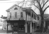
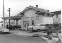
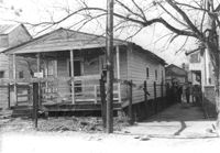
Push Grocery located at the southwest corner of Fishburne and St. Philip Streets, on site affected by the construction of Interstate 26 (I-26). Address: 77 Fishburne Street. Surveyor notations on back of photo: "Dkt.: 10.517. Property owner: Margaret J. Finn. Tract: 110. Station: 24+50 Lt. Southbound Lane Route 17. Date: March 5, 1963. In R/W - Bought." [See collection description for explanation of surveyor notations.]
Shed/outbuilding on site affected by the construction of the Crosstown. Address: 121 America Street. Surveyor notations on back of photo: "Dkt.: 10.518. Property owner: Vallie Talbert. Tract: 58. Station: 48+87 Lt. N.B. lane Route 17. Date: Mar. 7, 1963. All in R/W." [See collection description for explanation of surveyor notations.]
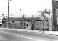
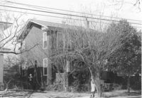
Buildings and lot on site affected by the construction of the Crosstown. Address: 620 King Street. Surveyor notations on back of photo: "Dkt.: 10.518. Property owner: News & Courier. Tract: 15. Station: 8+00 Lt. Line Street (Line #2) to 9+00 Lt. Date: Mar. 6, 1963. [Zero] Fence. [See collection description for explanation of surveyor notations.]
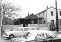
House (corner view, rear) on site affected by the construction of the Crosstown. Address: 94 Hanover Street. Surveyor notations on back of photo: "Dkt.: 10.518. Property owner: Mary Rivers. Tract: 46. Station: 44+90 CL line 9 east of Hanover Street. Date: Mar. 6, 1963. In R/W - Bought." [See collection description for explanation of surveyor notations.]
House (rear view) on site affected by the construction of the Crosstown. Address: 120 America Street. Surveyor notations on back of photo: "Dkt.: 10.518. Property owner: Geraldine M. Henry. Tract: 62. Station: 50+70 Rt. N.B. lane Route 17. Date: Mar. 7, 1963. In R/W - Bought." [See collection description for explanation of surveyor notations.]
House on site affected by the construction of the Crosstown. Address: 96 Hanover Street. Surveyor notations on back of photo: "Dkt.: 10.518. Property owner: Martha Pezant Hazzel. Tract: 47. Station: 45+20 Lt. line 9 east of Hanover Street. Date: Mar. 6, 1963. In R/W - Bought." [See collection description for explanation of surveyor notations.]
House on site affected by the construction of the Crosstown. Address: 94 Hanover Street. Surveyor notations on back of photo: "Dkt.: 10.518. Property owner: Mary Rivers. Tract: 46. Station: 44+90 CL line 9 east of Hanover Street. Date: Mar. 6, 1963. In R/W - Bought." [See collection description for explanation of surveyor notations.]
House on site affected by the construction of the Crosstown. Address: 90 Hanover Street. Surveyor notations on back of photo: "Dkt.: 10.518. Property owner: Jerusalem Baptist Church. Tract: 44. Station: 44+20 CL line 9 north of Cooper Street. Date: Mar. 6, 1963." [See collection description for explanation of surveyor notations.]
Corner view (rear) of building that may have previously been a gas station, on site affected by the construction of Interstate 26 (I-26). Address: 669 King Street. Surveyor notations on back of photo: "Dkt.: 10.517. Property owner: The Texas Co. Tract: 83. Station: 27+40 Rt. Northbound Lane Route 17. Date: March 5, 1963. In R/W - Bought." [See collection description for explanation of surveyor notations.]
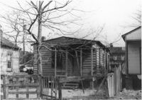
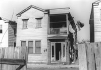
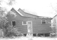
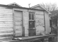
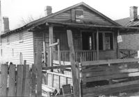
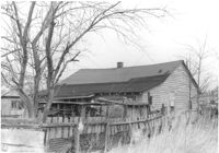
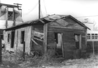
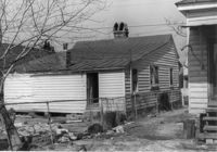
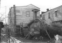
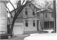
Dilapidated dwelling on site affected by the construction of Interstate 26 (I-26). Address: 4 D Street. Surveyor notations on back of photo: "Dkt.: 10.517. Property owner: Lawrence Felder, et al., Est. Tract: 15. Station: 5945+98 Lt. Date: February 21, 1963. In R/W - Bought." [See collection description for explanation of surveyor notations.]
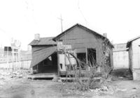
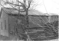
Dilapidated dwelling on site affected by the construction of Interstate 26 (I-26). Address: 6 D Street. Surveyor notations on back of photo: "Dkt.: 10.517. Property owner: Lawrence Felder, et al., Est. Tract: 15. Station: 5945+00 Lt. Date: February 21, 1963. In R/W - Bought." [See collection description for explanation of surveyor notations.]
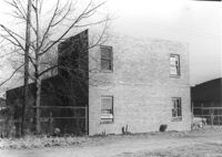
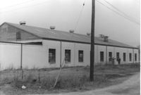
Cole Lumber Company structure (rear view), on site affected by the construction of Interstate 26 (I-26). Address from 1961 City Directory: 293 Huger Street. Address from 1951 Sanborn Map: 17 Huger Street. Surveyor notations on back of photo: "Dkt.: 10.517. Property owner: Charles E. Cole Lumber Co. Tract 1. Station: 5938+40 CL. Date: February 21, 1963." [See collection description for explanation of surveyor notations.]
Cole Lumber Company structure, on site affected by the construction of Interstate 26 (I-26). Address from 1961 City Directory: 293 Huger Street. Address from 1951 Sanborn Map: 17 Huger Street. Surveyor notations on back of photo: "Dkt.: 10.517. Property owner: Charles E. Cole Lumber Co. Tract 1. Station: 5938+40 CL. Date: February 21, 1963." [See collection description for explanation of surveyor notations.]
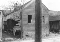
House (freedman's cottage) (side view) on site affected by the construction of Interstate 26 (I-26). Address: 24 Riker Street. Surveyor notations on back of photo: "Dkt.: 10.503. Property owner: Ethel Middleton. Tract: 65. Station: 5910+55 Rt. Date: May 30, 1963. In R/W - Bought." [See collection description for explanation of surveyor notations.]
Lot on site affected by the construction of Interstate 26 (I-26). Address: behind 12-14 Riker Street, which can be seen in the background. Surveyor notations on back of photo: "Dkt.: 10.503. Property owner: Katie C. Solomons. Tract: 62-A. Station: 5910+40 Lt. Date: Feb. 20, 1963. Buy fence & slat shed." [See collection description for explanation of surveyor notations.]
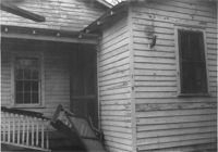
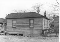
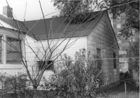
House (side view, rear) on site affected by the construction of Interstate 26 (I-26). Address: 7 Maple Street. Surveyor notations on back of photo: "Dkt.: 10.503. Property owner: James M. Knox. Tract: 56. Station: 5907+45 Lt. Date: Feb. 19, 1963. In R/W - Bought." [See collection description for explanation of surveyor notations.]
House (rear view) on site affected by the construction of Interstate 26 (I-26). Address: 2 Maple Street. Surveyor notations on back of photo: "Dkt.: 10.503. Property owner: Ida Breibart. Tract: 47. Station: 5906+05 Lt. Date: Feb. 19, 1963. In R/W - Bought." [See collection description for explanation of surveyor notations.]
House on site affected by the construction of Interstate 26 (I-26). Address: 4 Maple Street. Surveyor notations on back of photo: "Dkt.: 10.503. Property owner: Frank Donnelly, et al. Tract: 48. Station: 5906+10 Lt. Date: Feb. 19, 1963. In R/W - Bought." [See collection description for explanation of surveyor notations.]
House on site affected by the construction of Interstate 26 (I-26). Address: 7 Brigade Street. Surveyor notations on back of photo: "Dkt.: 10.503. Property owner: Idella C. Calvin. Tract: 45. Station: 5905+20 Lt. Date. Date: Feb. 19, 1963. In R/W - Bought." [See collection description for explanation of surveyor notations.]
House on site affected by the construction of Interstate 26 (I-26). Address: 5 Brigade Street. Surveyor notations on back of photo: "Dkt.: 10.503. Property owner: Maybelle Taylor. Tract: 46. Station: 5905+00 Lt. Date: Feb. 19, 1963. In R/W - Bought." [See collection description for explanation of surveyor notations.]
House on site affected by the construction of Interstate 26 (I-26). Address: 2 Maple Street. Surveyor notations on back of photo: "Dkt.: 10.503. Property owner: Ida Breibart. Tract: 47. Station: 5906+05 Lt. Date: Feb. 19, 1963. In R/W - Bought." [See collection description for explanation of surveyor notations.]
Structure on site affected by the construction of Interstate 26 (I-26). Address: 4 Maple Street. Surveyor notations on back of photo: "Dkt.: 10.503. Property owner: Frank Donnelly, et al. Tract: 48. Station: 5906+10 Lt. Date: Feb. 19, 1963. In R/W - Bought." [See collection description for explanation of surveyor notations.]
House/structure on site affected by the construction of the Crosstown. Address: 39 Lee Street (south side of street). Posted sign indicates it is closed by the Board of Health. Surveyor notations on back of photo: "Dkt.: 10.518. Property owner: Yetta B. Rosen. Tract: 69. Station: 52+65 Lt. N.B. lane Route 17. Date: Mar. 7, 1963. In R/W - Bought." [See collection description for explanation of surveyor notations.]
Rear of structure (see previous photo) on site affected by the construction of the Crosstown. Address: 32 Lee Street (south side of the street). Surveyor notations on back of photo: "Dkt.: 10.518. Property owner: Clifton Iron. Tract: 68. Station: 52+35 Lt. N.B. lane Route 17. Date: Mar. 7, 1963. In R/W - Bought." [See collection description for explanation of surveyor notations.]
House (rear view) on site affected by the construction of the Crosstown. Address: 39 Lee Street (south side of street). Surveyor notations on back of photo: "Dkt.: 10.518. Property owner: Yetta B. Rosen. Tract: 69. Station: 52+65 Lt. N.B. lane Route 17. Date: Mar. 7, 1963. In R/W - Bought." [See collection description for explanation of surveyor notations.]
Lot on site affected by the construction of the Crosstown. Address: 1 Lee Street. Surveyor notations on back of photo: "Dkt.: 10.518. Property owner: Ada Hamilton. Tract: 67. Station: 52+05 Lt. N.B. lane Route 17. Date: Mar. 7, 1963." [See collection description for explanation of surveyor notations.]
House on site affected by the construction of Interstate 26 (I-26). Address: 289 St. Philip Street. Surveyor notations on back of photo: "Dkt.: 10.517. Property owner: John Henry Mehrtens. Tract: 111. Station: 24+25 Rt. Southbound Lane Route 17. Date: March 5, 1963. In R/W - Bought." [See collection description for explanation of surveyor notations.]
House on site affected by the construction of Interstate 26 (I-26). Address: 79 Fishburne Street. Surveyor notations on back of photo: "Dkt.: 10.517. Property owner: Alma Belle Heath. Tract: 109. Station: 24+05 Lt. Southbound Lane Route 17. Date: March 5, 1963. In R/W - Bought." [See collection description for explanation of surveyor notations.]
House on site affected by the construction of Interstate 26 (I-26). Address: 268 St. Philip Street. Surveyor notations on back of photo: "Dkt.: 10.517. Property owner: Sara Fox. Tract: 113. Station: 25+20 Rt. Southbound Lane Route 17. Date: March 5, 1963. In R/W - Bought." [See collection description for explanation of surveyor notations.]
House on site affected by the construction of Interstate 26 (I-26). Address: 79 Fishburne Street. Surveyor notations on back of photo: "Dkt.: 10.517. Property owner: Alma Belle Heath. Tract: 109. Station: 24+05 Lt. Southbound Lane Route 17. Date: March 5, 1963. In R/W - Bought." [See collection description for explanation of surveyor notations.]
Ray Waits Mechanic/Body Shop (corner, one end of building, rear view) on site affected by the construction of Interstate 26 (I-26). Address: 11 Walnut Street. Surveyor notations on back of photo: "Dkt.: 10.517. Property owner: Roy Waites [sic] Motors, Inc. Tract: 45. Station: 5950±5950±67 Lt. Date: February 21, 1963." [See collection description for explanation of surveyor notations.]
Ray Waits Mechanic/Body Shop (rear view) on site affected by the construction of Interstate 26 (I-26). Address: 11 Walnut Street. Surveyor notations on back of photo: "Dkt.: 10.517. Property owner: Roy Waites [sic] Motors, Inc. Tract: 45. Station: 5950+60 Lt. - Line 6. Date: February 21, 1963." [See collection description for explanation of surveyor notations.]
House (rear view) on site affected by the construction of Interstate 26 (I-26). Address: 1 C Street. Fenced in area with wooden shed in foreground. Surveyor notations on back of photo: "Dkt.: 10.517. Property owner: Ernie C. Swack. Tract: 44. Station: 5951+10 Lt. - Line 2. Date: February 21, 1963. In R/W - Bought." [See collection description for explanation of surveyor notations.]
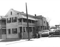
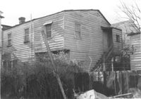
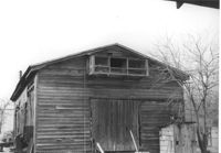
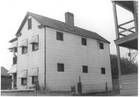
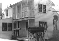
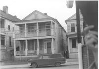
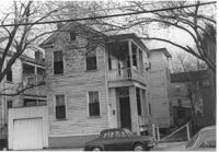
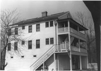
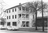
Dwelling on site affected by the construction of Interstate 26 (I-26). Address 13-27 C Street. Appears to be a multi-family residence. Surveyor notations on back of photo: "Dkt.: 10.517. Property owner: J.W.C. Bischoff. Tract: 39. Station: 5949+20 Rt. & Lt. Line 2. Date: February 21, 1963. In R/W - Bought." [See collection description for explanation of surveyor notations.]
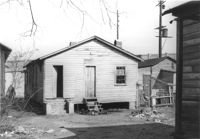
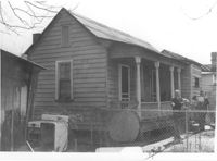
House on site affected by the construction of Interstate 26 (I-26). Address: 37 C Street. (1951 Sanborn map indicates the address is 25 C Street.) Surveyor notations on back of photo: "Dkt.: 10.517. Property owner: Sara Wilson. Tract: 25. Station: 5945+40 Lt. - Line 6. Date: February 21, 1963. In R/W - Bought." [See collection description for explanation of surveyor notations.]
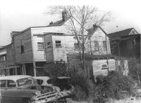
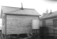
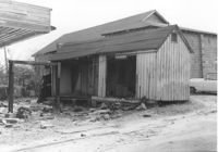
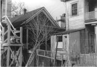
Dilapidated structure on site affected by the construction of Interstate 26 (I-26). Address: 35½ Poinsett Street. Bus in background. Surveyor notations on back of photo: "Dkt.: 10.503. Property owner: Manuel F. Fernandez. Tract: 106. Station: 5923+10 Lt. Date: Feb. 20, 1963. In R/W - Bought." [See collection description for explanation of surveyor notations.]
Lot between buildings, on site affected by the construction of Interstate 26 (I-26). Address: 35 Poinsett Street. Buses in background. Surveyor notations on back of photo: "Dkt.: 10.503. Property owner: S.C. Electric & Gas Co. [Tract number not indicated.] Station: 5922+50 Lt. Date: Feb. 20, 1963. Proximity." [See collection description for explanation of surveyor notations.]
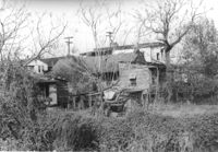
Dilapidated dwellings on site affected by the construction of Interstate 26 (I-26). Address: 19½ Poinsett Street. Surveyor notations on back of photo: "Dkt.: 10.503. Property owner: S.A.L.R.R. Tract: 105. Station: 5922+65 CL. Date: Feb. 20, 1963. In R/W - Bought." [See collection description for explanation of surveyor notations.]
Dilapidated dwellings on site affected by the construction of Interstate 26 (I-26). Address: 7 Poinsett Street. Surveyor notations on back of photo: "Dkt.: 10.503. Property owner: S.A.L.R.R. Tract: 105. Station: 5923+12 CL. Date: Feb. 20, 1963. In R/W - Bought." [See collection description for explanation of surveyor notations.]
Structures (rear view) on site affected by the construction of Interstate 26 (I-26). Address: 18 Addison Street. Surveyor notations on back of photo: "Dkt.: 10.503. Property owner: Hessie Alston. Tract: 93. Station: 5918+75 Lt. Date: Feb. 20, 1963. In R/W - Bought." [See collection description for explanation of surveyor notations.]
House on Sheppard Street on site affected by the construction of Interstate 26 (I-26). Address: 95 Sheppard Street. Surveyor notations on back of photo: "Dkt.: 10.517. Property owner: Bertha A. Kennedy, Est. Tract: 95. Station: 23+00 CL Northbound Lane Route 17. Date: March 5, 1963. In R/W - Bought." [See collection description for explanation of surveyor notations.]
Lot on site affected by the construction of Interstate 26 (I-26). Address; 101 Romney Street. Surrounding houses and structures in background. Surveyor notations on back of photo: "Dkt.: 10.503. Property owner: Arthur Rembert. Tract: 92. Station: 5917+75 Lt. Date: Feb. 20, 1963. In R/W - Bought." [See collection description for explanation of surveyor notations.]
House (rear view) on site affected by the construction of Interstate 26 (I-26). Address: 14 Addison Street. Surveyor notations on back of photo: "Dkt.: 10.503. Property owner: Eddie Jenkins, et al. Tract: 92-B. Station: 5918+00 Lt. Date: Feb. 20, 1963. In R/W - Bought." [See collection description for explanation of surveyor notations.]
House (freedman's cottage?) on site affected by the construction of Interstate 26 (I-26). Address: 18 Addison Street. Surveyor notations on back of photo: "Dkt.: 10.503. Property owner: Hessie Alston. Tract: 93. Station: 5918+75 Lt. Date: Feb. 20, 1963. In R/W - Bought." [See collection description for explanation of surveyor notations.]
House (rear view) on site affected by the construction of Interstate 26 (I-26). Address: 101 Romney Street. Surveyor notations on back of photo: "Dkt.: 10.503. Property owner: Arthur Rembert. Tract: 92. Station: 5916+90 Lt. Date: Feb. 20, 1963. In R/W - Bought." [See collection description for explanation of surveyor notations.]
House (rear view) on site affected by the construction of Interstate 26 (I-26). 157C Russell Street [157 Russell Street]. Surveyor notations on back of photo: "Dkt.: 10.503. Property owner: Addie Walker. Tract: 84. Station: 5914+65 Lt. Date: Feb. 20, 1963. In R/W - Bought." [See collection description for explanation of surveyor notations.]
House on site affected by the construction of Interstate 26 (I-26). Address: 9 Boyer Street. Surveyor notations on back of photo: "Dkt.: 10.503. Property owner: Atlantic Coast Life Ins. Co. Tract: 85. Station: 5914+95 Lt. Date: Feb. 20, 1963. In R/W - Bought." [See collection description for explanation of surveyor notations.]
House (rear view) on site affected by the construction of Interstate 26 (I-26). Address: 104 Romney Street. Surveyor notations on back of photo: "Dkt.: 10.503. Property owner: Sidney Goff. Tract: 87. Station: 5915+80 Lt. Date: Feb. 20, 1963. In R/W - Bought." [See collection description for explanation of surveyor notations.]
House on site affected by the construction of Interstate 26 (I-26). Address: 157C Russell Street [157 Russell Street]. Surveyor notations on back of photo: "Dkt.: 10.503. Property owner: Addie Walker. Tract: 84. Station: 5914+65 Lt. Date: Feb. 20, 1963. In R/W - Bought." [See collection description for explanation of surveyor notations.]
House on site affected by the construction of Interstate 26 (I-26). Address: 1199 King Street. Surveyor notations on back of photo: "Dkt.: 10.503. Property owner: Nancy J. Wandell. Tract: 19. Station: 5895+85 Rt. Date: Feb. 19, 1963." [See collection description for explanation of surveyor notations.]
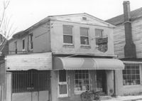
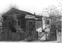
Walker's Grocery and house (behind grocery) on site affected by the construction of Interstate 26 (I-26). Address: 17 Boyer Street. Surveyor notations on back of photo: "Dkt.: 10.503. Property owner: Addie Walker. Tract: 84. Station: 5914+60 Lt. Date: Feb. 20, 1963. In R/W - Bought." [See collection description for explanation of surveyor notations.]
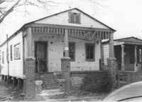
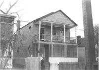
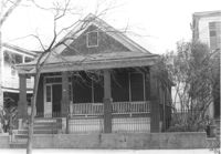
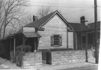
House (freedman's cottage) on site affected by the construction of Interstate 26 (I-26). Address: 110 Russell Street. (1951 Sanborn map indicates the address is 157A Russell Street [157 Russell Street].) Surveyor notations on back of photo: "Dkt.: 10.503. Property owner: Arline Williams. Tract: 83. Station: 5915+00 Rt. Date: Feb. 20, 1963. In R/W - Bought." [See collection description for explanation of surveyor notations.]
House (side view) on site affected by the construction of Interstate 26 (I-26). Address: 29 Mount Pleasant Street. Joseph Floyd Manor (Mount Pleasant Street and King Street) faintly in background. On corner of on Mount Pleasant Street and King Street. Surveyor notations on back of photo: "Dkt.: 10.503. Property owner: Charles B. Cromer, et al. Tract: 14. Station: 5892+90 Lt. Date: Feb. 19, 1963. In R/W - Bought." [See collection description for explanation of surveyor notations.]
Lot behind houses on site affected by the construction of Interstate 26 (I-26). Address: 157C Russell Street [157 Russell Street]. Rear of 102 Romney Street in background (two-story house). Surveyor notations on back of photo: "Dkt.: 10.503. Property owner: Violet Cone. Tract: 82. Station: 5914+80 Rt. Date: Feb. 20, 1963. In R/W - Bought." [See collection description for explanation of surveyor notations.]
Houses and outbuilding (rear view) on site affected by the construction of Interstate 26 (I-26). Address: 17 Boyer Street. Surveyor notations on back of photo: "Dkt.: 10.503. Property owner: Addie Walker. Tract: 84. Station: 5914+60 Lt. Date: Feb. 20, 1963. In R/W - Bought." [See collection description for explanation of surveyor notations.]
House (rear view) on site affected by the construction of Interstate 26 (I-26). Address: 172 Laurel Avenue. Surveyor notations on back of photo: "Dkt.: 10.503. Property owner: Marguerite E. Jacques. Tract: 13. Station: 5893+20 Lt. Date: Feb. 19, 1963. In R/W - Bought." [See collection description for explanation of surveyor notations.]
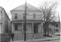
House on site affected by the construction of the Crosstown. Address: 92 Hanover Street. (Number on front door: 104. Portion of neighboring house at right; number painted on front door: 102.) Surveyor notations on back of photo: "Dkt.: 10.518. Property owner: Jerusalem Baptist Church. Tract: 45. Station: 44+60 CL line 9 east of Hanover Street. Date: Mar. 6, 1963." [See collection description for explanation of surveyor notations.]
House (corner view, rear) on site affected by the construction of the Crosstown. Address: 59 Lee Street (corner of Lee Street and Hanover Street). Looking towards street corner. Surveyor notations on back of photo: "Dkt.: 10.518. Property owner: Melvin Whaley. Tract: 40. Station: 44+35 Rt. S.B. lane Route 17. Date: Mar. 6, 1963. In R/W - Bought. [See collection description for explanation of surveyor notations.]
House (rear view) on site affected by the construction of the Crosstown. Address: 86 Hanover Street. Neighboring house also shown. Surveyor notations on back of photo: "Dkt.: 10.518. Property owner: Ester Bosser. Tract: 42. Station: 43+65 CL line 9 north of Cooper Street. Date: Mar. 6, 1963. In R/W - Bought. [See collection description for explanation of surveyor notations.]
House (rear view) on site affected by the construction of the Crosstown. Address: 92 Hanover Street. (Number on front door: 104.) Surveyor notations on back of photo: "Dkt.: 10.518. Property owner: Jerusalem Baptist Church. Tract: 45. Station: 44+60 CL line 9 east of Hanover Street. Date: Mar. 6, 1963." [See collection description for explanation of surveyor notations.]
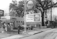
Shell gas station on site affected by the construction of Interstate 26 (I-26). Address: 1227 King Street. Surveyor notations on back of photo: "Dkt.: 10.503. Property owner: Shell Oil Co. Tract: 14-A. Station: 5893+80 Lt. Date: Feb. 19, 1963." [See collection description for explanation of surveyor notations.]
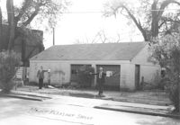
Garage building on site affected by the construction of Interstate 26 (I-26). Address: 29 Mount Pleasant Street. Surveyor notations on back of photo: "Dkt.: 10.503. Property owner: Charles B. Cromer, et al. Tract: 14. Station: 5893+35 Lt. Date: Feb. 19, 1963. Bought." [See collection description for explanation of surveyor notations.]
House on site affected by the construction of Interstate 26 (I-26). Address: 13 Maple Street. Surveyor notations on back of photo: "Dkt.: 10.503. Property owner: Aliene Cox Tindall. Tract: 53. Station: 5907+65 Rt. Date: Feb. 19, 1963. In R/W - Bought." [See collection description for explanation of surveyor notations.]
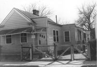
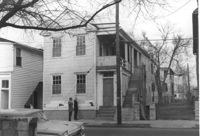
House on street corner, on site affected by the construction of Interstate 26 (I-26). Address: 681 King Street. View of street corner. Surveyor notations on back of photo: "Dkt.: 10.517. Property owner: H.H. Rabens. Tract: 119 & 120. Station: 27+00 Rt. Southbound Lane Route 17. Date: March 5, 1963. In R/W - Bought." [See collection description for explanation of surveyor notations.]
House on site affected by the construction of Interstate 26 (I-26). Address: 679 King Street. Surveyor notations on back of photo: "Dkt.: 10.517. Property owner: Meta B. Williamson. Tract: 121. Station: 27+00 Rt. Southbound Lane Route 17. Date: March 5, 1963. In R/W - Bought." [See collection description for explanation of surveyor notations.]
House on site affected by the construction of Interstate 26 (I-26). Address: 679 King Street. Surveyor notations on back of photo: "Dkt.: 10.517. Property owner: Meta B. Williamson. Tract: 121. Station: 27+00 Rt. Southbound Lane Route 17. Date: March 5, 1963. In R/W - Bought." [See collection description for explanation of surveyor notations.]
House on site affected by the construction of Interstate 26 (I-26). Address: 67 Fishburne Street. Surveyor notations on back of photo: "Dkt.: 10.517. Property owner: H.H. Rabens. Tract: 119 & 120. Station: 26+60 CL Southbound Lane Route 17. Date: March 5, 1963. In R/W - Bought." [See collection description for explanation of surveyor notations.]
House on site affected by the construction of Interstate 26 (I-26). Address: 67 Fishburne Street. Surveyor notations on back of photo: "Dkt.: 10.517. Property owner: H.H. Rabens. Tract: 119 & 120. Station: 26+60 CL Southbound Lane Route 17. Date: March 5, 1963. In R/W - Bought." [See collection description for explanation of surveyor notations.]
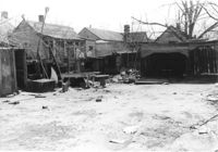
House and portion of building, on site affected by the construction of the Crosstown. Address: 82 Cooper Street. Front facade of building has stepped parapet. Surveyor notations on back of photo: "Dkt.: 10.518. Property owner: O.L. Scott. Tract: 8. Station: 38+75 CL N.B. lane Route 17. Date: Mar. 6, 1963. In R/W - Bought. [See collection description for explanation of surveyor notations.]
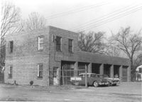
Cole Lumber Company, presumably main office building, on site affected by the construction of Interstate 26 (I-26). Address from 1961 City Directory: 293 Huger Street. Address from 1951 Sanborn Map: 17 Huger Street. Surveyor notations on back of photo: "Dkt.: 10.517. Property owner: Charles E. Cole Lumber Co. Tract 1. Station: 5937+70 Lt. Date: February 21, 1963." [See collection description for explanation of surveyor notations.]
Cole Lumber Company, presumably main office building, on site affected by the construction of Interstate 26 (I-26). Address from 1961 City Directory: 293 Huger Street. Address from 1951 Sanborn Map: 17 Huger Street. Surveyor notations on back of photo: "Dkt.: 10.517. Property owner: Cole Lumber Co. Tract 1. Station: 5937+70 Lt. Date: March 5, 1963. In R/W - Bought." [See collection description for explanation of surveyor notations.]