House on site affected by the construction of the Crosstown. Address: 55 Aiken Street. Surveyor notations on back of photo: "Dkt.: 10.518. Property owner: Julius Mitchell. Tract: 53. Station: 47+20 Rt. N.B. lane Route 17. Date: Mar. 7, 1963." [See collection description for explanation of surveyor notations.]
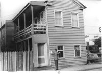
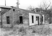
House (and neighboring buildings) on site affected by the construction of the Crosstown. Address: 60-58 Aiken Street. Public Telephone sign in foreground. Surveyor notations on back of photo: "Dkt.: 10.518. Property owner: Congaree Jenkins, Est. Tract: 54. Station: 48+00 Rt. N.B. lane Route 17. Date: Mar. 7, 1963." [See collection description for explanation of surveyor notations.]
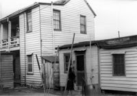
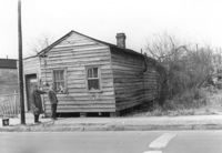
House (rear view) and outbuilding on site affected by the construction of the Crosstown. Address: 60-58 Aiken Street. Surveyor notations on back of photo: "Dkt.: 10.518. Property owner: Congaree Jenkins, Est. Tract: 54. Station: 48+00 Rt. N.B. lane Route 17. Date: Mar. 7, 1963." [See collection description for explanation of surveyor notations.]
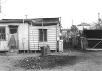
Outbuilding and lot on site affected by the construction of the Crosstown. Address: 60-58 Aiken Street. Surveyor notations on back of photo: "Dkt.: 10.518. Property owner: Congaree Jenkins, Est. Tract: 54. Station: 48+35 Rt. N.B. lane Route 17. Date: Mar. 7, 1963." [See collection description for explanation of surveyor notations.]
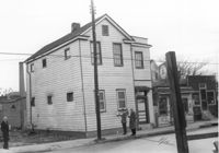
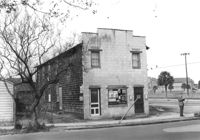
Corner grocery store on site affected by the construction of the Crosstown. Address: 121 America Street. View of street corner (America Street and Lee Street). Surveyor notations on back of photo: "Dkt.: 10.518. Property owner: Vallie Talbert. Tract: 58. Station: 49+50 Lt. N.B. lane Route 17. Date: Mar. 7, 1963." [See collection description for explanation of surveyor notations.]
Side view of corner grocery store on site affected by the construction of the Crosstown. Address: 121 America Street. Surveyor notations on back of photo: "Dkt.: 10.518. Property owner: Vallie Talbert. Tract: 58. Station: 49+50 Lt. N.B. lane Route 17. Date: Mar. 7, 1963." [See collection description for explanation of surveyor notations.]
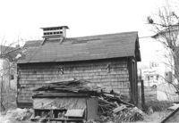
Shed/outbuilding on site affected by the construction of the Crosstown. Address: 121 America Street. Surveyor notations on back of photo: "Dkt.: 10.518. Property owner: Vallie Talbert. Tract: 58. Station: 48+87 Lt. N.B. lane Route 17. Date: Mar. 7, 1963. All in R/W." [See collection description for explanation of surveyor notations.]
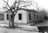
House on site affected by the construction of the Crosstown. Address: 119 America Street. Surveyor notations on back of photo: "Dkt.: 10.518. Property owner: J.A. Barrineau. Tract; 59. Station: 49+55 Rt. N.B. lane Route 17. Date: Mar. 7, 1963. In R/W - Bought." [See collection description for explanation of surveyor notations.]
House (rear view) on site affected by the construction of the Crosstown. Address: 119 America Street. Surveyor notations on back of photo: "Dkt.: 10.518. Property owner: J.A. Barrineau. Tract; 59. Station: 49+55 Rt. N.B. lane Route 17. Date: Mar. 7, 1963. In R/W - Bought." [See collection description for explanation of surveyor notations.]
House (freedman's cottage) on site affected by the construction of the Crosstown. Address: 115 America Street. Surveyor notations on back of photo: "Dkt.: 10.518. Property owner: Jerusalem Baptist Church. Tract: 60. Station: 49+60 Rt. N.B. lane Route 17. Date: Mar. 7, 1963." [See collection description for explanation of surveyor notations.]