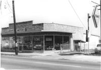
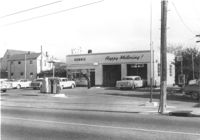
Lafayette Motors, on site affected by the construction of Interstate 26 (I-26). Address: 680 King Street. Surveyor notations on back of photo: "Dkt.: 10.517. Property owner: Raymond A. Wittschen. Tract: 122. Station: 28+35 Lt. Southbound Lane Route 17. Date: March 5, 1963. Proximity." [See collection description for explanation of surveyor notations.]
Lafayette Motors, on site affected by the construction of Interstate 26 (I-26). Address: 680 King Street. Surveyor notations on back of photo: "Dkt.: 10.517. Property owner: Raymond A. Wittschen. Tract: 122. Station: 28+35 Lt. Southbound Lane Route 17. Date: March 5, 1963. Proximity." [See collection description for explanation of surveyor notations.]
Lafayette Motors (rear view), on site affected by the construction of Interstate 26 (I-26). Address: 680 King Street. Surveyor notations on back of photo: "Dkt.: 10.517. Property owner: Raymond A. Wittschen. Tract: 122. Station: 28+35 Lt. Southbound Lane Route 17. Date: March 5, 1963. Proximity." [See collection description for explanation of surveyor notations.]
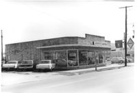
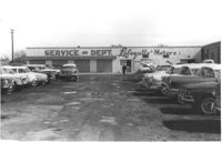
Lafayette Motors Service Dept., on site affected by the construction of Interstate 26 (I-26). Address: 680 King Street. Surveyor notations on back of photo: "Dkt.: 10.517. Property owner: Raymond A. Wittschen. Tract: 122. Station: 29±00 Lt. Southbound Lane Route 17. Date: March 5, 1963. Proximity." [See collection description for explanation of surveyor notations.]
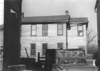
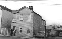
House (side view) on site affected by the construction of the Crosstown. Address: 55 Lee Street. Surveyor notations on back of photo: "Dkt.: 10.518. Property owner: Augustus G. Purvis. Tract: 49. Station: 45+55 Lt. N.B. lane Route 17. Date: Mar. 6, 1963. In R/W - Bought." [See collection description for explanation of surveyor notations.]
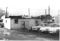
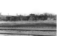
Lot with railroad tracks in foreground, behind Lafayette Motors, on site affected by the construction of Interstate 26 (I-26). Address: 680 King Street. Surveyor notations on back of photo: "Dkt.: 10.517. Property owner: Raymond A. Wittschen. Tract: 122. Station: 31± to 32± Rt. & Lt. Southbound Lane Route 17. Date: March 5, 1963." [See collection description for explanation of surveyor notations.]
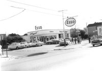
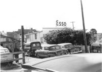
Esso (Humble) gas station on site affected by the construction of the Crosstown. Address: 53 Lee Street (corner of Lee Street and Aiken Street). Surveyor notations on back of photo: "Dkt.: 10.518. Property owner: Humble Oil Refining Co. Tract: 51. Station: 46+65 Lt. N.B. lane Route 17. Date: Mar. 6, 1963. In R/W - Bought." [See collection description for explanation of surveyor notations.]
Esso (Humble) gas station (corner view) on site affected by the construction of the Crosstown. Address: 53 Lee Street (corner of Lee Street and Aiken Street). Surveyor notations on back of photo: "Dkt.: 10.518. Property owner: Humble Oil Refining Co. Tract: 51. Station: 46+65 Lt. N.B. lane Route 17. Date: Mar. 6, 1963. In R/W - Bought." [See collection description for explanation of surveyor notations.]
Cars in lot behind Esso (Humble) gas station on site affected by the construction of the Crosstown. Address: 53 Lee Street (corner of Lee Street and Aiken Street). Surveyor notations on back of photo: "Dkt.: 10.518. Property owner: Humble Oil Refining Co. Tract: 51. Station: 46+65 Lt. N.B. lane Route 17. Date: Mar. 6, 1963. In R/W - Bought." [See collection description for explanation of surveyor notations.]
House on site affected by the construction of the Crosstown. Address: 55 Aiken Street. Surveyor notations on back of photo: "Dkt.: 10.518. Property owner: Julius Mitchell. Tract: 53. Station: 47+20 Rt. N.B. lane Route 17. Date: Mar. 7, 1963." [See collection description for explanation of surveyor notations.]