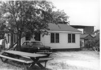
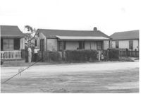
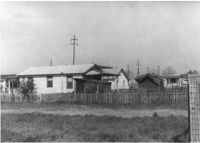
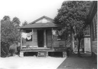
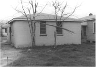
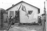
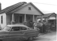
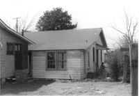
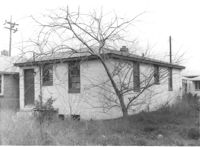
House on site affected by the construction of Interstate 26 (I-26). Address: 2157 Heriot Street. Picnic table in foreground. Surveyor notations on back of photo: "Dkt.: 10.490. Property owner: Thos. W. Towns [Thomas W. Towns]. Tract: 147-C. Station: 230' Lt. Sta. 5880+40. Date: May 15, 1962. Proximity." [See collection description for explanation of surveyor notations.]
House (corner view, rear) on site affected by the construction of Interstate 26 (I-26). Surveyor notations on back of photo: "Dkt.: 10.490. Property owner: Gladys Owens. Tract: 110. Station: 5830+00 Rt. Date: March 22, 1962. In R/W - Bought." [See collection description for explanation of surveyor notations.]
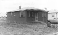
House on site affected by the construction of Interstate 26 (I-26). Surveyor notations on back of photo: "Dkt.: 10.490. Property owner: Harold I. Sherman, et al. Tract: 109-A. Station: 5828+70 Rt. Date: March 22, 1962. In R/W - Bought." [See collection description for explanation of surveyor notations.]
House on site affected by the construction of Interstate 26 (I-26). Surveyor notations on back of photo: "Dkt.: 10.490. Property owner: Christine Morris, et al. Tract: 109. Station: 5828+75 Rt. Date: March 22, 1962. In R/W - Bought." [See collection description for explanation of surveyor notations.]
House on site affected by the construction of Interstate 26 (I-26). Surveyor notations on back of photo: "Dkt.: 10.490. Property owner: Henry Ford, et al. Tract: 138-C. Station: 5858+40 Lt. Date: August 29, 1962. In R/W - Bought." [See collection description for explanation of surveyor notations.]
House on site affected by the construction of Interstate 26 (I-26). Surveyor notations on back of photo: "Dkt.: 10.490. Property owner: Louis Green. Tract: 138-B. Station: 5858+70 Lt. Date: August 29, 1962. In R/W - Bought." [See collection description for explanation of surveyor notations.]
House on site affected by the construction of Interstate 26 (I-26). Surveyor notations on back of photo: "Dkt.: 10.490. Property owner: Gladys Owens. Tract: 110. Station: 5830+00 Rt. Date: March 22, 1962. In R/W - Bought." [See collection description for explanation of surveyor notations.]
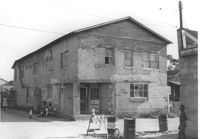
Building on site affected by the construction of Interstate 26 (I-26). View of street corner. Appears to previously have been a corner store named "Upper 10," perhaps with residence on second floor. Surveyor notations on back of photo: "Dkt.: 10.490. Property owner: Robert Martin. Tract: 38. Station: 5957+45 on CL Line 'G'. Date: September 11, 1962. In R/W - Bought." [See collection description for explanation of surveyor notations.]
House (rear view), possibly multi-family dwelling, on site affected by the construction of Interstate 26 (I-26). Surveyor notations on back of photo: "Dkt.: 10.490. Property owner: F.F. Bellinger, et al. Tract: 49. Station: 5800+50 Rt. Line 'G'. Date: September 11, 1962. To be cut off at R/W by SCHD [SC Highway Department]." [See collection description for explanation of surveyor notations.]
House (rear view) and lot on site affected by the construction of Interstate 26 (I-26). [Address 2208 Delano.] Surveyor notations on back of photo: "Dkt.: 10.490. Property owner: O.D. Tanner. Tract: 77. Station: 5822+32 Rt. Line 'G'. Date: March 22, 1962. In R/W - Bought." [See collection description for explanation of surveyor notations.]
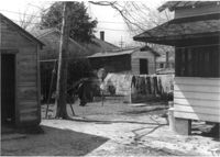
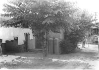
Structures and backyard behind house on site affected by the construction of Interstate 26 (I-26). [Address 2207 Delano.] Surveyor notations on back of photo: "Dkt.: 10.490. Property owner: Harry G. Cusack. Tract: 80. Station: 5824+15 Lt. Date: March 22, 1962. In R/W - Bought." [See collection description for explanation of surveyor notations.]
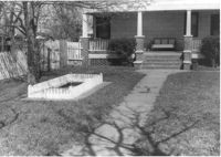
House and front yard on site affected by the construction of Interstate 26 (I-26). [Address 2208 Delano.] Surveyor notations on back of photo: "Dkt.: 10.490. Property owner: Geo. F. Garner [George F. Garner]. Tract: 78. Station: 5822+50 Lt. Date: March 22, 1962. In R/W - Bought." [See collection description for explanation of surveyor notations.]
House (rear view) on site affected by the construction of Interstate 26 (I-26). Surveyor notations on back of photo: "Dkt.: 10.490. Property owner: George L. Haseldor. Tract: 55. Station: 5801+15 Lt. Line 'F'. Date: September 12, 1962. In R/W - Bought." [See collection description for explanation of surveyor notations.]
House on site affected by the construction of Interstate 26 (I-26). Surveyor notations on back of photo: "Dkt.: 10.490. Property owner: Barney Witherspoon, et al. Tract: 53. Station: 5800+40 on CL Line 'F'. Date: September 12, 1962. In R/W - Bought." [See collection description for explanation of surveyor notations.]
House on site affected by the construction of Interstate 26 (I-26). Surveyor notations on back of photo: "Dkt.: 10.490. Property owner: William Parineau, et al. Tract: 54. Station: 5800+80 Lt. Line 'F'. Date: September 12, 1962. In R/W - Bought." [See collection description for explanation of surveyor notations.]
House on site affected by the construction of Interstate 26 (I-26). Surveyor notations on back of photo: "Dkt.: 10.490. Property owner: George L. Haseldor. Tract: 55. Station: 5801+15 Lt. Line 'F'. Date: September 12, 1962. In R/W - Bought." [See collection description for explanation of surveyor notations.]
House (corner view, rear) on site affected by the construction of Interstate 26 (I-26). Surveyor notations on back of photo: "Dkt.: 10.490. Property owner: Herbert Williams, et al. Tract: 108. Station: 5828+90 Rt. Date: March 22, 1962. In R/W - Bought." [See collection description for explanation of surveyor notations.]
House (rear view) on site affected by the construction of Interstate 26 (I-26). Surveyor notations on back of photo: "Dkt.: 10.490. Property owner: Daisey Bough, et al. Tract: 106. Station: 5828+90 Lt. Tract: 105. Station: 5828+90 Lt. Date: March 22, 1962. In R/W - Bought." [See collection description for explanation of surveyor notations.]
House (corner view, rear) on site affected by the construction of Interstate 26 (I-26). Surveyor notations on back of photo: "Dkt.: 10.490. Property owner: Christine Morris, et al. Tract: 109. Station: 5828+75 Rt. Date: March 22, 1962. In R/W - Bought." [See collection description for explanation of surveyor notations.]
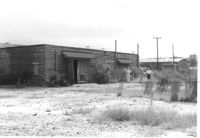
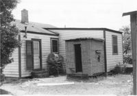
House (side view) and lot, on site affected by the construction of Interstate 26 (I-26). Surveyor notations on back of photo: "Dkt.: 10.490. Property owner: Jacob Bennekin. Tract: 138-A. Station: 5858+90 Lt. Date: August 29, 1962. In R/W - Bought." [See collection description for explanation of surveyor notations.]
House on site affected by the construction of Interstate 26 (I-26). Surveyor notations on back of photo: "Dkt.: 10.490. Property owner: Daisey Bough, et al. Tract: 106. Station: 5828+90 Lt. Tract: 105. Station: 5828+90 Lt. Date: March 22, 1962. In R/W - Bought." [See collection description for explanation of surveyor notations.]
House (rear view) on site affected by the construction of Interstate 26 (I-26). Surveyor notations on back of photo: "Dkt.: 10.490. Property owner: Louis Green. Tract: 138-B. Station: 5858+70 Lt. Date: August 29, 1962. In R/W - Bought." [See collection description for explanation of surveyor notations.]
House on site affected by the construction of Interstate 26 (I-26). Surveyor notations on back of photo: "Dkt.: 10.490. Property owner: Herbert Williams, et al. Tract: 108. Station: 5828+90 Rt. Date: March 22, 1962. In R/W - Bought." [See collection description for explanation of surveyor notations.]
House on site affected by the construction of Interstate 26 (I-26). Surveyor notations on back of photo: "Dkt.: 10.490. Property owner: Jacob Bennekin. Tract: 138-A. Station: 5858+90 Lt. Date: August 29, 1962. In R/W - Bought." [See collection description for explanation of surveyor notations.]
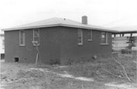
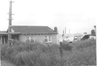
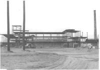
Virginia-Carolina Chemical Corp. structures on site affected by the construction of Interstate 26 (I-26). [VC Chemical Corp. was located on King Street Extn.] Surveyor notations on back of photo: "Dkt.: 10.490. Property owner: V.C. Chemical Co. Tract: 1. Station: 5800+00 Rt. Date: September 11, 1962. To be cut off at R/W." [See collection description for explanation of surveyor notations.]
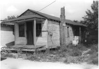
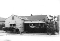
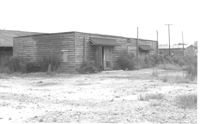
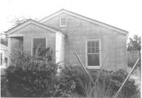
House on site affected by the construction of Interstate 26 (I-26). Building address number 2135. Surveyor notations on back of photo: "Dkt.: 10.490. Property owner: Sheppard Siders. Tract: 138-E. Station: 5858+00 Lt. Date: May 15, 1962. Owner to cut porch to clear R/W." [See collection description for explanation of surveyor notations.]
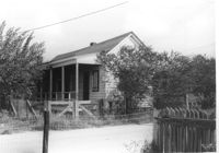
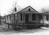
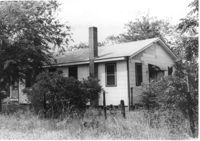
House at 2161 Heriot Street, on site affected by the construction of Interstate 26 (I-26). Address: 2159 Heriot Street. Surveyor notations on back of photo: "Dkt.: 10.490. Property owner: Henry Yaschik. Tract: 147-B. Station: 175' Lt. Sta. 5879+35. Date: May 15, 1962. Proximity." [See collection description for explanation of surveyor notations.]
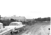
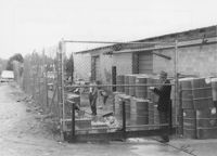
Dirt road and Charleston Oil Co. structures, on site affected by the construction of Interstate 26 (I-26). Surveyor notations on back of photo: "Dkt.: 10.490. Property owner: Charleston Oil Co. Tract: 140 and 140-A. Station: 5861+51 Rt. and Lt. (crosses CL). Date: August 29, 1962. In R/W - Bought." [See collection description for explanation of surveyor notations.]
House (rear view) on site affected by the construction of Interstate 26 (I-26). Surveyor notations on back of photo: "Dkt.: 10.490. Property owner: Henry Ford, et al. Tract: 138-C. Station: 5858+40 Lt. Date: August 29, 1962. In R/W - Bought." [See collection description for explanation of surveyor notations.]
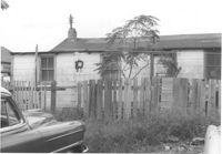
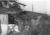
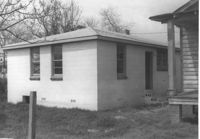
Structure on site affected by the construction of Interstate 26 (I-26). Surveyor notations on back of photo: "Dkt.: 10.490. Property owner: Ashley River Realty Co. Tract: 142. Station: 5876+60 Lt. Date: August 29, 1962. In R/W - Bought." [See collection description for explanation of surveyor notations.]
Structure on site affected by the construction of Interstate 26 (I-26). Surveyor notations on back of photo: "Dkt.: 10.490. Property owner: Ashley River Realty Co. Tract: 142. Station: 5876+60 Lt. Date: August 29, 1962. In R/W - Bought." [See collection description for explanation of surveyor notations.]
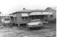
Renken Boat Co, on site affected by the widening of Route 171 (Folly Road). Surveyor notations on back of photo: "Dkt.: 10.494. Property owner: Renken Finance Co. Tract: 19. Station: 157+00 Lt. Date: Mar. 21, 1962. Proximity. [See collection description for explanation of surveyor notations.]
House (rear view) on site affected by the construction of Interstate 26 (I-26). [Building address number 2003(?).]Surveyor notations on back of photo: "Dkt.: 10.490. Property owner: L. Bradley. Tract: 39. Station: 5797+70 on CL Line 'G'. Date: September 11, 1962. In R/W - Bought." [See collection description for explanation of surveyor notations.]
House on site affected by the construction of Interstate 26 (I-26). Building address number 2009(?). Surveyor notations on back of photo: "Dkt.: 10.490. Property owner: John Simmons, Est. Tract: 42. Station: 5798+60 on CL Line 'G'. Date: September 12, 1962. In R/W - Bought." [See collection description for explanation of surveyor notations.]
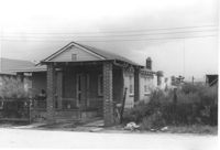
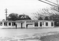
Furniture Repair Shop, on site affected by the widening of Route 171 (Folly Road). Surveyor notations on back of photo: "Dkt.: 10.494. Property owner: Isadora Bischoff. Tract: 32. Station: 162+00 Lt. Date: Mar. 21, 1962. Owner to cut off at R/W. [See collection description for explanation of surveyor notations.]
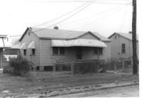
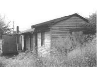
House and garage or shed on site affected by the construction of Interstate 26 (I-26). Surveyor notations on back of photo: "Dkt.: 10.490. Property owner: Loretta Gillard [Loretta Gaillard]. Tract: 56. 5800+00 Lt. Line 'G'. Date: September 12, 1962. In R/W - Bought." [See collection description for explanation of surveyor notations.]
House (rear view) on site affected by the construction of Interstate 26 (I-26). Surveyor notations on back of photo: "Dkt.: 10.490. Property owner: Loretta Gillard [Loretta Gaillard]. Tract: 56. 5801+50 Lt. Line 'F'. Date: September 12, 1962. In R/W - Bought." [See collection description for explanation of surveyor notations.]
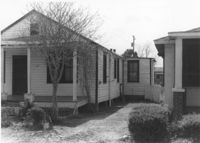
House (rear view) on site affected by the construction of Interstate 26 (I-26). Address: 2132 Montford Avenue. Surveyor notations on back of photo: "Dkt.: 10.490. Property owner: Wm. P. Mahon [William P. Mahon]. Tract: 172. Station: 5884+30 Rt. Date: May 15, 1962. In R/W - Bought." [See collection description for explanation of surveyor notations.]
House (rear view) on site affected by the construction of Interstate 26 (I-26). Address: 2136 Montford Avenue. Surveyor notations on back of photo: "Dkt.: 10.490. Property owner: Werner R. Mohrmann. Tract: 170. Station: 5884 ±20 Rt. Date: August 29, 1962. In R/W - Bought." [See collection description for explanation of surveyor notations.]
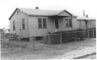
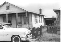
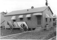
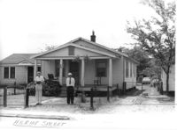
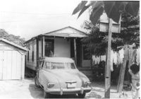
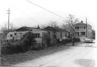
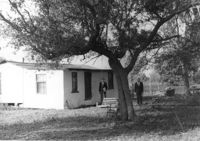
House, trailer, and street on site affected by the construction of Interstate 26 (I-26). Surveyor notations on back of photo: "Dkt.: 10.490. Property owner: Jacob Myers, et al. Tract: 86-A. Station: 5823+90 Rt. Date: March 22, 1962. Proximity to house. Owner to move trailer." [See collection description for explanation of surveyor notations.]
House (rear view) and backyard on site affected by the construction of Interstate 26 (I-26). Surveyor notations on back of photo: "Dkt.: 10.490. Property owner: Christer Bell King. Tract: 96-D. Station: 5826+95 Rt. Date: March 22, 1962. Proximity" [See collection description for explanation of surveyor notations.]
House (corner view, rear) on site affected by the construction of Interstate 26 (I-26). Surveyor notations on back of photo: "Dkt.: 10.490. Property owner: Buddy Floyd, et al. Tract: 90. Station: 5825+10 Lt. Date: March 22, 1962. In R/W - Bought." [See collection description for explanation of surveyor notations.]
House on site affected by the construction of Interstate 26 (I-26). [Address 2213 Delano.] Surveyor notations on back of photo: "Dkt.: 10.490. Property owner: Cath. Mason Lewis. Tract: 83. Station: 5824+00 on CL. Date: March 22, 1962. In R/W - Bought." [See collection description for explanation of surveyor notations.]
House on site affected by the construction of Interstate 26 (I-26). [Address 2213 Delano.] Surveyor notations on back of photo: "Dkt.: 10.490. Property owner: Cath. Mason Lewis. Tract: 83. Station: 5824+00 on CL. Date: March 22, 1962. In R/W - Bought." [See collection description for explanation of surveyor notations.]
House (rear view) and shed on site affected by the construction of Interstate 26 (I-26). Surveyor notations on back of photo: "Dkt.: 10.490. Property owner: Minnie R. Sherman. Tract: 92. Station: 5827+10 Lt. Date: March 22, 1962. In R/W - Bought." [See collection description for explanation of surveyor notations.]
House (corner view, rear) on site affected by the construction of Interstate 26 (I-26). Surveyor notations on back of photo: "Dkt.: 10.490. Property owner: Harold I. Sherman. Tract: 101. Station: 5827+80 Lt. Date: March 22, 1962. In R/W - Bought." [See collection description for explanation of surveyor notations.]
House (rear view) on site affected by the construction of Interstate 26 (I-26). Surveyor notations on back of photo: "Dkt.: 10.490. Property owner: Geo. L. Robertson [George L. Robertson]. Tract: 87. Station: 5825+30 Rt. Date: May 15, 1962. In R/W - Bought." [See collection description for explanation of surveyor notations.]
House (corner view, rear) on site affected by the construction of Interstate 26 (I-26). Surveyor notations on back of photo: "Dkt.: 10.490. Property owner: Minnie R. Sherman. Tract:96. Station: 5826+50 Rt. Date: March 22, 1962. In R/W - Bought." [See collection description for explanation of surveyor notations.]
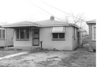
House on site affected by the widening of Route 171 (Folly Road). Surveyor notations on back of photo: "Dkt.: 10.494. Property owner: Sophie Sabel, Est. Tract: 97. Station: 372+20 Lt. Date: Mar. 21, 1962. To be cut off at R/W by SCHD [SC Highway Dept.?]. [See collection description for explanation of surveyor notations.]
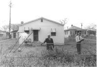
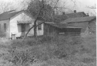
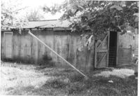
Outbuilding on site affected by the construction of Interstate 26 (I-26). Address: 2117 Weaver Avenue. See also I-26 Photos 1448-1449. Surveyor notations on back of photo: "Dkt.: 10.490. Property owner: Marion Butler, et al. Tract: 192. Station: 5888+80 Rt. Date: May 15, 1962. In R/W - Bought." [See collection description for explanation of surveyor notations.]