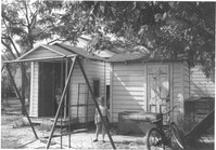
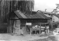
Two sheds and swing set, with standing girl, on site affected by the construction of Interstate 26 (I-26). Address: 2124 Weaver Avenue. Surveyor notations on back of photo: "Dkt.: 10.490. Property owner: Harry L. Rumph, Jr. Tract: 188. Station: 30' Lt. Sta. 5886-55. Date: May 15, 1962. In R/W - Bought." [See collection description for explanation of surveyor notations.]
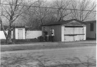
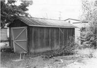
Garage and shed on site affected by the construction of Interstate 26 (I-26). Surveyor notations on back of photo: "Dkt.: 10.490. Property owner: Mostester Brown [Mostester Brown?]. Tract: 87-C. Station: 5825+45 Rt. Date: March 22, 1962. In R/W - Bought." [See collection description for explanation of surveyor notations.]
Garage and shed on site affected by the construction of Interstate 26 (I-26). Surveyor notations on back of photo: "Dkt.: 10.490. Property owner: Mostester Brown [Montester Brown?]. Tract: 87-C. Station: 5825+45 Rt. [Undated.] In R/W - Bought." [See collection description for explanation of surveyor notations.]
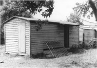
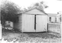
Shed on site affected by the construction of Interstate 26 (I-26). Address: 2130 Montford Avenue. Surveyor notations on back of photo: "Dkt.: 10.490. Property owner: Rosa Lee Knight. Tract: 173. Station: 5884+00 Lt. Date: May 15, 1962. In R/W - Bought." [See collection description for explanation of surveyor notations.]
Two sheds on site affected by the construction of Interstate 26 (I-26).Address: 2124 Weaver Avenue. Surveyor notations on back of photo: "Dkt.: 10.490. Property owner: Harry L. Rumph, Jr. Tract: 188. Station: 5887±00 Lt. Date: August 29, 1962. In R/W - Bought." [See collection description for explanation of surveyor notations.]
Shed on site affected by the construction of Interstate 26 (I-26). Surveyor notations on back of photo: "Dkt.: 10.490. Property owner: Leah D. Governor. Tract: 58. Station: 5800+60 Rt. Line 'G'. Date: September 12, 1962. In R/W - Bought." [See collection description for explanation of surveyor notations.]
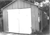
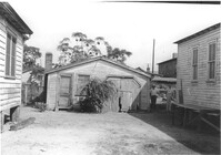
Garage and/or storage building on site affected by the construction of Interstate 26 (I-26).Address: 1317 King Street. Presumably part of the Rose Garden Tourist Court; see I-26 Photo 1467. Surveyor notations on back of photo: "Dkt.: 10.490. Property owner: The Long Corporation. Tract: 200. Station: 5889+45 Lt. Date: September 11, 1962. In R/W - Bought." [See collection description for explanation of surveyor notations.]
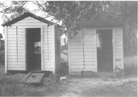
Shed on site affected by the construction of Interstate 26 (I-26). Address: 2128 Montford Avenue. Surveyor notations on back of photo: "Dkt.: 10.490. Property owner: Chas. W. Jenkins, Jr. [Charles W. Jenkins, Jr.]. Tract: 174. Station: 50' Lt. Sta. 5884+00. Date: May 15, 1962. In R/W - Bought." [See collection description for explanation of surveyor notations.]
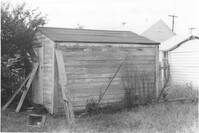
Shed on site affected by the construction of Interstate 26 (I-26). Address: 2133 Weaver Avenue. Surveyor notations on back of photo: "Dkt.: 10.490. Property owner: Arthur P. Jones. Tract: 199. Station: 5889+25 Rt. Date: May 15, 1962. In R/W - Bought." [See collection description for explanation of surveyor notations.]
Shed on site affected by the construction of Interstate 26 (I-26). Address: 2136 Montford Avenue. Surveyor notations on back of photo: "Dkt.: 10.490. Property owner: Werner R. Mohrmann. Tract: 170. Station: 5884 ±20 Rt. Date: August 29, 1962. In R/W - Bought." [See collection description for explanation of surveyor notations.]
Shed on site affected by the construction of Interstate 26 (I-26). Address: 2120 Weaver Avenue. Surveyor notations on back of photo: "Dkt.: 10.490. Property owner: Troy R. Bevill. Tract: 190. Station: 100' Lt. Sta. 5887+00. Date: May 15, 1962. In R/W - Bought." [See collection description for explanation of surveyor notations.]
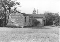
Shed or garage associated with Francis Brown Methodist Church, on site affected by the construction of Interstate 26 (I-26). [2202 Joppa.] Surveyor notations on back of photo: "Dkt.: 10.490. Property owner: Francis Brown Meth. Church. Tract: 52. Station: 5799+80 Lt. Line 'F'. Date: September 12, 1962. To be cut off at R/W by SCHD [SC Highway Department]." [See collection description for explanation of surveyor notations.]