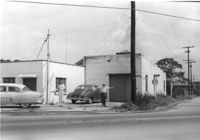
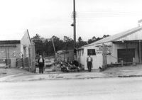
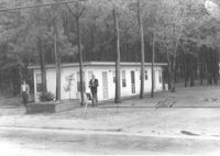
Building on site affected by the construction of Interstate 26 (I-26). On corner of Meeting Street and ? View of street corner. Surveyor notations on back of photo: "Dkt.: 10.510. Property owner: Ada M. Crosby Life Est. Tract: 66-C. Station: 5810+60 Lt. Line B (Meeting Street). Date: Sept. 12, 1962. Proximity." [See collection description for explanation of surveyor notations.]
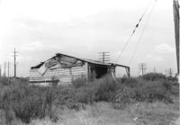
Dilapidated wood-sided structure on site affected by the construction of Interstate 26 (I-26). On grounds with many power lines on property. On Meeting Street/Meeting Street Road Surveyor notations on back of photo: "Dkt.: 10.510. Property owner: Geo. Fabian, Jr. Tract: 67. Station: 5796+10 on CL Lt. (Meeting Street). Date: Sept. 12, 1962. In R/W - Bought." [See collection description for explanation of surveyor notations.]
House on site affected by the construction of Interstate 26 (I-26). On Meeting Street/Meeting Street Road. Surveyor notations on back of photo: "Dkt.: 10.510. Property owner: Geo. Fabian, Jr. Tract: 67. Station: 5797+40 Lt. (Meeting Street). Date: Sept. 12, 1962. In R/W - Bought." [See collection description for explanation of surveyor notations.]
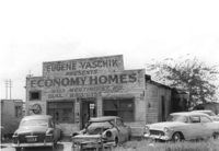
Dilapidated building on site affected by the construction of Interstate 26 (I-26). Several cars parked in front and on side of building. Painted on front facade: Eugene Yaschik Presents Economy Homes, 2323 Meeting Street Rd. Surveyor notations on back of photo: "Dkt.: 10.510. Property owner: Geo. Fabian, Jr. Tract: 67. Station: 5798+00 Lt. CL (Meeting Street). Date: Sept. 12, 1962. In R/W - Bought." [See collection description for explanation of surveyor notations.]
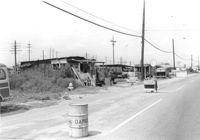
Lot on site affected by the construction of Interstate 26 (I-26). On Meeting Street/Meeting Street Road. View down street showing dilapidated structures on side of road, which is already a construction site. Surveyor notations on back of photo: "Dkt.: 10.510. Property owner: Geo. Fabian, Jr. Tract: 67. Station: 5801+60 - 5802+65 Lt. (Meeting Street). Date: Sept. 12, 1962. In R/W - Bought." [See collection description for explanation of surveyor notations.]
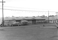
Renken Boat Co, on site affected by the widening of Route 171 (Folly Road). Surveyor notations on back of photo: "Dkt.: 10.494. Property owner: Renken Finance Co. Tract: 19. Station: 157+00 Lt. Date: Mar. 21, 1962. Proximity. [See collection description for explanation of surveyor notations.]
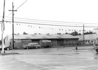
Renken Boat Co, on site affected by the widening of Route 171 (Folly Road). Surveyor notations on back of photo: "Dkt.: 10.494. Property owner: Renken Finance Co. Tract: 19. Station: 157+00 Lt. Date: Mar. 21, 1962. Proximity. [See collection description for explanation of surveyor notations.]
Renken Boat Co, on site affected by the widening of Route 171 (Folly Road). Surveyor notations on back of photo: "Dkt.: 10.494. Property owner: Renken Finance Co. Tract: 19. Station: 157+00 Lt. Date: Mar. 21, 1962. Proximity. [See collection description for explanation of surveyor notations.]
Renken Boat Co, on site affected by the widening of Route 171 (Folly Road). Surveyor notations on back of photo: "Dkt.: 10.494. Property owner: Renken Finance Co. Tract: 19. Station: 157+00 Lt. Date: Mar. 21, 1962. Proximity. [See collection description for explanation of surveyor notations.]
Renken Boat Co, on site affected by the widening of Route 171 (Folly Road). Surveyor notations on back of photo: "Dkt.: 10.494. Property owner: Renken Finance Co. Tract: 19. Station: 157+00 Lt. Date: Mar. 21, 1962. Proximity. [See collection description for explanation of surveyor notations.]
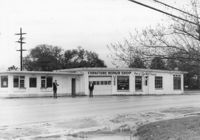
Furniture Repair Shop, on site affected by the widening of Route 171 (Folly Road). Surveyor notations on back of photo: "Dkt.: 10.494. Property owner: Isadora Bischoff. Tract: 32. Station: 162+00 Lt. Date: Mar. 21, 1962. Owner to cut off at R/W. [See collection description for explanation of surveyor notations.]
Furniture Repair Shop, on site affected by the widening of Route 171 (Folly Road). Surveyor notations on back of photo: "Dkt.: 10.494. Property owner: Isadora Bischoff. Tract: 32. Station: 162+00 Lt. Date: Mar. 21, 1962. Owner to cut off at R/W. [See collection description for explanation of surveyor notations.]
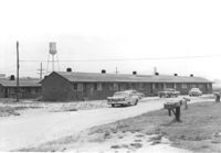
Building on site affected by the widening of Route 171 (Folly Road). (May be apartments or a motel.) Surveyor notations on back of photo: "Dkt.: 10.494. Property owner: James E. Smoot, et al. Tract: 34. Station: 170+80 Rt. Date: Mar. 21, 1962. Proximity. [See collection description for explanation of surveyor notations.]
Building on site affected by the widening of Route 171 (Folly Road). (May be apartments or a motel.) Surveyor notations on back of photo: "Dkt.: 10.494. Property owner: James E. Smoot, et al. Tract: 34. Station: 170+80 Rt. Date: Mar. 21, 1962. Proximity. [See collection description for explanation of surveyor notations.]
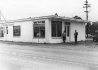
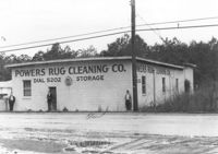
Powers Rug Cleaning Co, on site affected by the widening of Route 171 (Folly Road). Surveyor notations on back of photo: "Dkt.: 10.494. Property owner: K. & Dorothy Ohlinge. Tract: 38. Station: 174+30 Rt. Date: Mar. 21, 1962. Proximity. [See collection description for explanation of surveyor notations.]
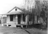
House on or in vicinity of King Street Extn., on site affected by the construction of Interstate 26 (I-26). Surveyor notations on back of photo: "Dkt.: 10.490. Property owner: V.C. Chemical Co. Tract: 1. Station: 5808+50 Rt. (Line F). Date: September 11, 1962. In R/W - Bought." [See collection description for explanation of surveyor notations.]
House (side view) on or in vicinity of King Street Extn., on site affected by the construction of Interstate 26 (I-26). Surveyor notations on back of photo: "Dkt.: 10.490. Property owner: V.C. Chemical Co. Tract: 1. Station: 5808+50 Rt. (Line F). Date: September 11, 1962. In R/W - Bought." [See collection description for explanation of surveyor notations.]
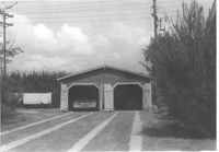
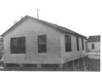
Garage on or in vicinity of King Street Extn., on site affected by the construction of Interstate 26 (I-26). Surveyor notations on back of photo: "Dkt.: 10.490. Property owner: V.C. Chemical Co. Tract: 1. Station: 5807+80 Rt. (Line F). Date: September 11, 1962. In R/W - Bought." [See collection description for explanation of surveyor notations.]
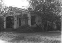
House on or in vicinity of King Street Extn., on site affected by the construction of Interstate 26 (I-26). Surveyor notations on back of photo: "Dkt.: 10.490. Property owner: V.C. Chemical Co. Tract: 1. Station: 5808+00 Lt. (Line F). Date: September 11, 1962. Partially in R/W." [See collection description for explanation of surveyor notations.]
House on or in vicinity of King Street Extn., on site affected by the construction of Interstate 26 (I-26). Surveyor notations on back of photo: "Dkt.: 10.490. Property owner: V.C. Chemical Co. Tract: 1. Station: 5809+00 Lt. (Line F). Date: September 11, 1962. Proximity." [See collection description for explanation of surveyor notations.]
House on or in vicinity of King Street Extn., on site affected by the construction of Interstate 26 (I-26). Surveyor notations on back of photo: "Dkt.: 10.490. Property owner: V.C. Chemical Co. Tract: 1. Station: 5810+10 Lt. (Line F). Date: September 11, 1962. Partially in R/W." [See collection description for explanation of surveyor notations.]
House (rear view) on or in vicinity of King Street Extn., on site affected by the construction of Interstate 26 (I-26). Surveyor notations on back of photo: "Dkt.: 10.490. Property owner: V.C. Chemical Co. Tract: 1. Station: 5809+10 Lt. (Line F). Date: September 11, 1962. In R/W - Bought." [See collection description for explanation of surveyor notations.]
House on or in vicinity of King Street Extn., on site affected by the construction of Interstate 26 (I-26). Surveyor notations on back of photo: "Dkt.: 10.490. Property owner: V.C. Chemical Co. Tract: 1. Station: 5809+10 Lt. (Line F). Date: September 11, 1962. In R/W - Bought." [See collection description for explanation of surveyor notations.]
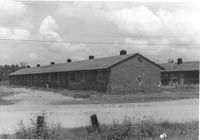
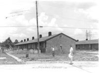
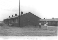
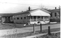
Multi-family housing on Pickens Street (312 Pickens Street), on site affected by the construction of Interstate 26 (I-26). Surveyor notations on back of photo: "Dkt.: 10.490. Property owner: Ashley Development Co. Tract: 1-A. Station: 5769+37 to 5771+00 Rt. Date: September 11, 1962. In R/W - Bought." [See collection description for explanation of surveyor notations.]
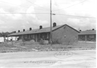
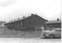
Multi-family housing on Pickens Street (310 Pickens Street), on site affected by the construction of Interstate 26 (I-26). Surveyor notations on back of photo: "Dkt.: 10.490. Property owner: Ashley Development Co. Tract: 1-A. Station: 5769+35 to 5771+00 on CL. Date: September 11, 1962. In R/W - Bought." [See collection description for explanation of surveyor notations.]
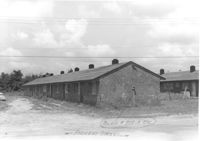
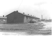
Multi-family housing on Pickens Street (308 Pickens Street), on site affected by the construction of Interstate 26 (I-26). Surveyor notations on back of photo: "Dkt.: 10.490. Property owner: Ashley Development Co. Tract: 1-A. Station: 5769+75 to 5771+25 Lt. Date: September 11, 1962. In R/W - Bought." [See collection description for explanation of surveyor notations.]
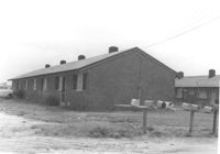
Multi-family housing on Pickens Street (306 Pickens Street), on site affected by the construction of Interstate 26 (I-26). Surveyor notations on back of photo: "Dkt.: 10.490. Property owner: Ashley Development Co. Tract: 1-A. Station: 5769+75 to 5771+25 Lt. Date: September 11, 1962. To be cut off at R/W line by owner." [See collection description for explanation of surveyor notations.]
Multi-family housing on Pickens Street (301 Pickens Street), on site affected by the construction of Interstate 26 (I-26). Surveyor notations on back of photo: "Dkt.: 10.490. Property owner: Ashley Development Co. Tract: 1-A. Station: 5772+19 to 5773+80 Lt. Date: September 11, 1962. In R/W - Bought." [See collection description for explanation of surveyor notations.]
Multi-family housing on Pickens Street (303 Pickens Street), on site affected by the construction of Interstate 26 (I-26). Surveyor notations on back of photo: "Dkt.: 10.490. Property owner: Ashley Development Co. Tract: 1-A. Station: 5772+19 to 5773+80 Left. Date: September 11, 1962. In R/W - Bought." [See collection description for explanation of surveyor notations.]
Multi-family housing on Pickens Street (305 Pickens Street), on site affected by the construction of Interstate 26 (I-26). Surveyor notations on back of photo: "Dkt.: 10.490. Property owner: Ashley Development Co. Tract: 1-A. Station: 5771+90 to 5772+90 Rt. Date: September 11, 1962. In R/W - Bought." [See collection description for explanation of surveyor notations.]
Multi-family housing on Pickens Street (307 Pickens Street), on site affected by the construction of Interstate 26 (I-26). Surveyor notations on back of photo: "Dkt.: 10.490. Property owner: Ashley Development Co. Tract: 1-A. Station: 5771+90 to 5772+90 Rt. Date: September 11, 1962. To be cut off at R/W by owner." [See collection description for explanation of surveyor notations.]
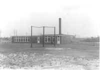
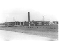
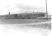
Daniel Jenkins Elementary School, on site affected by the construction of Interstate 26 (I-26). Surveyor notations on back of photo: "Dkt.: 10.490. Property owner: Ashley Development Co. Tract: 1-A. Station: 5775+65 to 5776+60 Lt. Date: September 11, 1962. In R/W - Bought." [See collection description for explanation of surveyor notations.]
Daniel Jenkins Elementary School, on site affected by the construction of Interstate 26 (I-26). Surveyor notations on back of photo: "Dkt.: 10.490. Property owner: V.C. Chemical Co. Tract: 1. Station: 5775+65 to 5776+60 Lt. Date: September 11, 1962. In R/W - Bought." [See collection description for explanation of surveyor notations.]
Daniel Jenkins Elementary School, on site affected by the construction of Interstate 26 (I-26). Surveyor notations on back of photo: "Dkt.: 10.490. Property owner: V.C. Chemical Co. Tract: 1. Station: 5776+00 to 5776+40 Rt. Date: September 11, 1962. To be cut off at R/W by owner." [See collection description for explanation of surveyor notations.]
Daniel Jenkins Elementary School, on site affected by the construction of Interstate 26 (I-26). Surveyor notations on back of photo: "Dkt.: 10.490. Property owner: V.C. Chemical Co. Tract: 1. Station: 5776+00 to 5776+40 Rt. Date: September 11, 1962. To be cut off at R/W by owner." [See collection description for explanation of surveyor notations.]
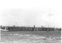
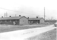
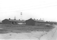
Daniel Jenkins Homes, federal multi-family housing, on Richland Avenue (119 Richland Avenue and 120 Richland Avenue), on site affected by the construction of Interstate 26 (I-26). Surveyor notations on back of photo: "Dkt.: 10.490. Property owner: Ashley Development Co. Tract: 1-A. Station: 5783+10 to 5784+00 Lt. Date: September 11, 1962. To be cut off at R/W by owner." [See collection description for explanation of surveyor notations.]
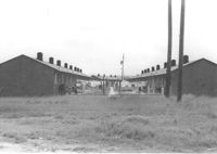
Daniel Jenkins Homes, federal multi-family housing, on Richland Avenue (115 Richland Avenue and 116 Richland Avenue), on site affected by the construction of Interstate 26 (I-26). Surveyor notations on back of photo: "Dkt.: 10.490. Property owner: Ashley Development Co. Tract: 1-A. Station: 5786+50 to 5787+40 Rt. and Lt. Date: September 11, 1962. To be cut off at R/W by owner." [See collection description for explanation of surveyor notations.]
Daniel Jenkins Homes, federal multi-family housing, on Richland Avenue (111 Richland Avenue and 112 Richland Avenue), on site affected by the construction of Interstate 26 (I-26). Surveyor notations on back of photo: "Dkt.: 10.490. Property owner: Ashley Development Co. Tract: 1-A. Station: 5788+35 to 5789+25 Rt. and Lt. Date: September 11, 1962. In R/W - Bought." [See collection description for explanation of surveyor notations.]
Daniel Jenkins Homes, federal multi-family housing, on Richland Avenue (113 Richland Avenue and 114 Richland Avenue), on site affected by the construction of Interstate 26 (I-26). Surveyor notations on back of photo: "Dkt.: 10.490. Property owner: Ashley Development Co. Tract: 1-A. Station: Rt. 5788+00. Date: September 11, 1962. In R/W - Bought." [See collection description for explanation of surveyor notations.]
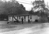
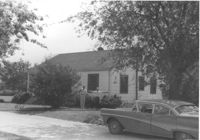
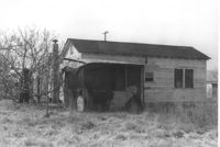
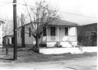
House on site affected by the construction of Interstate 26 (I-26). Surveyor notations on back of photo: "Dkt.: 10.490. Property owner: Robert M. Huckabee. Tract: 14. Station: 5818+00 (Lt. Line "G"). Date: March 22, 1962. In R/W - Bought." [See collection description for explanation of surveyor notations.]
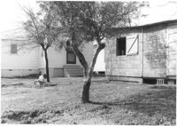
House (rear view) on site affected by the construction of Interstate 26 (I-26). Surveyor notations on back of photo: "Dkt.: 10.490. Property owner: Robert M. Huckabee. Tract: 14. Station: 5818+00 (Lt. Line "G"). Date: March 22, 1962. In R/W - Bought." [See collection description for explanation of surveyor notations.]
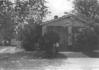
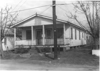
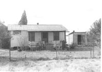
House on site affected by the construction of Interstate 26 (I-26). Surveyor notations on back of photo: "Dkt.: 10.490. Property owner: Kate Metts. Tract: 15. Station: 5818+20 Rt. Date: March 22, 1962. In R/W - Bought." [See collection description for explanation of surveyor notations.]
House (rear view) on site affected by the construction of Interstate 26 (I-26). Surveyor notations on back of photo: "Dkt.: 10.490. Property owner: Kate Metts. Tract: 15. Station: 5818+20 Rt. Date: March 22, 1962. In R/W - Bought." [See collection description for explanation of surveyor notations.]
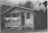
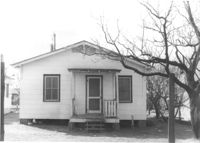
House on site affected by the construction of Interstate 26 (I-26). Surveyor notations on back of photo: "Dkt.: 10.490. Property owner: Charles L. Smith. Tract: 16. Station: 5818+20 Lt. Date: March 22, 1962. In R/W - Bought." [See collection description for explanation of surveyor notations.]
House (rear view) on site affected by the construction of Interstate 26 (I-26). Surveyor notations on back of photo: "Dkt.: 10.490. Property owner: Charles L. Smith. Tract: 16. Station: 5818+20 Lt. Date: March 22, 1962. In R/W - Bought." [See collection description for explanation of surveyor notations.]
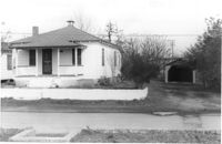
House on site affected by the construction of Interstate 26 (I-26). Building address number 2202. Surveyor notations on back of photo: "Dkt.: 10.490. Property owner: Julius A. Cercoply. Tract: 17. Station: 5818+20 Lt. Date: March 22, 1962. In R/W - Bought." [See collection description for explanation of surveyor notations.]
House on site affected by the construction of Interstate 26 (I-26). Building address number 2202. Surveyor notations on back of photo: "Dkt.: 10.490. Property owner: Julius A. Cercoply. Tract: 17. Station: 5818+20 Lt. Date: March 22, 1962. In R/W - Bought." [See collection description for explanation of surveyor notations.]
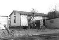
House (rear view) yard, and shed, on site affected by the construction of Interstate 26 (I-26). [Building address number 2202]. Surveyor notations on back of photo: "Dkt.: 10.490. Property owner: Julius A. Cercoply. Tract: 17. Station: 5818+20 Lt. Date: March 22, 1962. In R/W - Bought." [See collection description for explanation of surveyor notations.]
House on site affected by the construction of Interstate 26 (I-26). Surveyor notations on back of photo: "Dkt.: 10.490. Property owner: Joe B. Cusak, Jr. Tract: 18. Station: 5819+85 Lt. Date: March 22, 1962. In R/W - Bought." [See collection description for explanation of surveyor notations.]
House (rear view) on site affected by the construction of Interstate 26 (I-26). Surveyor notations on back of photo: "Dkt.: 10.490. Property owner: Joe B. Cusak, Jr. Tract: 18. Station: 5819+85 Lt. Date: March 22, 1962. In R/W - Bought." [See collection description for explanation of surveyor notations.]