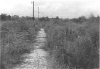
Virginia-Carolina Chemical Corp. land, on site affected by the construction of Interstate 26 (I-26). [VC Chemical Corp. was located on King Street Extn.] Surveyor notations on back of photo: "Dkt.: 10.490. Property owner: V.C. Chemical Co. Tract: 1. Station: 5804+00 and 5805+00 Rt. Date: September 11, 1962. All in R/W." [See collection description for explanation of surveyor notations.]
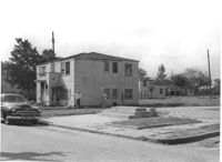
Two two-story dwellings (rear view) on site affected by the construction of Interstate 26 (I-26). Address: 1317 King Street. Presumably part of the Rose Garden Tourist Court; see I-26 Photo 1467. Surveyor notations on back of photo: "Dkt.: 10.490. Property owner: The Long Corporation. Tract: 200. Station: 5+50 & 6+20 Lt. (Mt. Pleasant Street). Date: September 11, 1962. In R/W - Bought." [See collection description for explanation of surveyor notations.]
Two two-story dwellings (rear view) on site affected by the construction of Interstate 26 (I-26).Address: 1317 King Street. Presumably part of the Rose Garden Tourist Court; see I-26 Photo 1467. Surveyor notations on back of photo: "Dkt.: 10.490. Property owner: The Long Corporation. Tract: 200. Station: 5889+00 to 5890+00 Lt. Date: September 11, 1962. In R/W - Bought." [See collection description for explanation of surveyor notations.]
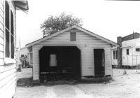
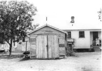
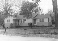
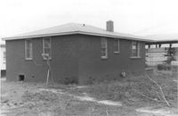
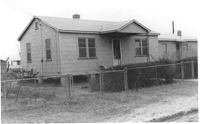
Garage on site affected by the construction of Interstate 26 (I-26). Address: 1340 Rutledge Avenue. Surveyor notations on back of photo: "Dkt.: 10.490. Property owner: Louise S. Carter. Tract: 155. Station: 5880+40 Rt. (house). 5880+10 Lt. (garage). Date: May 15, 1962. In R/W - Bought." [See collection description for explanation of surveyor notations.]
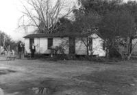
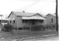
House (rear view) and shed/garage, on site affected by the construction of Interstate 26 (I-26). Address: 1344 Rutledge Avenue. Surveyor notations on back of photo: "Dkt.: 10.490. Property owner: Louise S. Carter. Tract: 154. Station: 5880+00 Rt. (house). 5880+00 Lt. (garage). Date: May 15, 1962. In R/W - Bought." [See collection description for explanation of surveyor notations.]
Two-story dwelling on site affected by the construction of Interstate 26 (I-26). Address: 1317 King Street. Adjacent lot in foreground appears to have had a building on it which had been razed. View of street corner; northwest corner of King Street and Mt. Pleasant Street. Presumably part of the Rose Garden Tourist Court; see I-26 Photo 1467. Surveyor notations on back of photo: "Dkt.: 10.490. Property owner: The Long Corporation. Tract: 200. Station: 7+10 Lt. (Mt. Pleasant Street). Date: September 11, 1962. To be cut off at R/W by SCHD [SC Highway Department]." [See collection description for explanation of surveyor notations.]
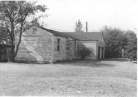
Garage and/or storage building on site affected by the construction of Interstate 26 (I-26).Address: 1317 King Street. Presumably part of the Rose Garden Tourist Court; see I-26 Photo 1467. Surveyor notations on back of photo: "Dkt.: 10.490. Property owner: The Long Corporation. Tract: 200. Station: 5889+45 Lt. Date: September 11, 1962. In R/W - Bought." [See collection description for explanation of surveyor notations.]
House on site affected by the widening of Route 171 (Folly Road). Surveyor notations on back of photo: "Dkt.: 10.494. Property owner: Sophie Sabel, Est. Tract: 97. Station: 372+20 Lt. Date: Mar. 21, 1962. To be cut off at R/W by SCHD [SC Highway Dept.?]. [See collection description for explanation of surveyor notations.]
House on site affected by the widening of Route 171 (Folly Road). Surveyor notations on back of photo: "Dkt.: 10.494. Property owner: G.L. Brown, et al. Tract: 69. Station: 218+90 Rt. Date: Mar. 21, 1962. Proximity. [See collection description for explanation of surveyor notations.]
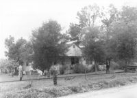
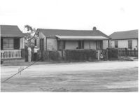
House on site affected by the widening of Route 171 (Folly Road). Surveyor notations on back of photo: "Dkt.: 10.494. Property owner: H.P. Duke. Tract: 51. Station: 186+65 Rt. Date: Mar. 21, 1962. Proximity. [See collection description for explanation of surveyor notations.]
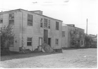
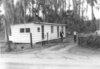
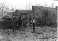
Building on site affected by the widening of Route 171 (Folly Road). Surveyor notations on back of photo: "Dkt.: 10.494. Property owner: John Harleston. Tract: 62. Station: 195+50 Rt. Date: Mar. 21, 1962. Moving item. [See collection description for explanation of surveyor notations.]
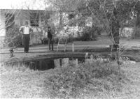
Pool and pump, on site affected by the widening of Route 171 (Folly Road). Surveyor notations on back of photo: "Dkt.: 10.494. Property owner: H.P. Duke. Tract: 51. Station: 186+65 Rt. Date: Mar. 21, 1962. Loss of pool and pump. [See collection description for explanation of surveyor notations.]
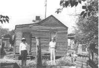
House (freedman's cottage) (rear view) on site affected by the construction of Interstate 26 (I-26). Surveyor notations on back of photo: "Dkt.: 10.490. Property owner: Martha Robinson, Est. Tract: 87-B. Station: 5825+00 Rt. Date: August 29, 1962. Proximity." [See collection description for explanation of surveyor notations.]
House (freedman's cottage) (rear view) on site affected by the construction of Interstate 26 (I-26). Surveyor notations on back of photo: "Dkt.: 10.490. Property owner: Ruth M. Bontz. Tract: 87-A. Station: 5824+80 Rt. Date: March 22, 1962. Proximity." [See collection description for explanation of surveyor notations.]
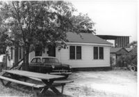
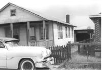
House on site affected by the construction of Interstate 26 (I-26). Address: 2157 Heriot Street. Picnic table in foreground. Surveyor notations on back of photo: "Dkt.: 10.490. Property owner: Thos. W. Towns [Thomas W. Towns]. Tract: 147-C. Station: 230' Lt. Sta. 5880+40. Date: May 15, 1962. Proximity." [See collection description for explanation of surveyor notations.]
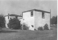
House (corner view, rear) on site affected by the construction of Interstate 26 (I-26). Surveyor notations on back of photo: "Dkt.: 10.490. Property owner: Gladys Owens. Tract: 110. Station: 5830+00 Rt. Date: March 22, 1962. In R/W - Bought." [See collection description for explanation of surveyor notations.]
House on site affected by the construction of Interstate 26 (I-26). Surveyor notations on back of photo: "Dkt.: 10.490. Property owner: Harold I. Sherman, et al. Tract: 109-A. Station: 5828+70 Rt. Date: March 22, 1962. In R/W - Bought." [See collection description for explanation of surveyor notations.]
House on site affected by the construction of Interstate 26 (I-26). Surveyor notations on back of photo: "Dkt.: 10.490. Property owner: Christine Morris, et al. Tract: 109. Station: 5828+75 Rt. Date: March 22, 1962. In R/W - Bought." [See collection description for explanation of surveyor notations.]
House on site affected by the construction of Interstate 26 (I-26). Surveyor notations on back of photo: "Dkt.: 10.490. Property owner: Henry Ford, et al. Tract: 138-C. Station: 5858+40 Lt. Date: August 29, 1962. In R/W - Bought." [See collection description for explanation of surveyor notations.]
House on site affected by the construction of Interstate 26 (I-26). Surveyor notations on back of photo: "Dkt.: 10.490. Property owner: Louis Green. Tract: 138-B. Station: 5858+70 Lt. Date: August 29, 1962. In R/W - Bought." [See collection description for explanation of surveyor notations.]