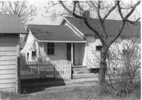
House (rear view) on site affected by the construction of Interstate 26 (I-26). [Building address number 2205 (2205 Peace).] Surveyor notations on back of photo: "Dkt.: 10.490. Property owner: W.W. Tuten. Tract: 73. Station: 5821+90 Lt. Date: March 22, 1962. In R/W - Bought." [See collection description for explanation of surveyor notations.]
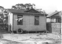
House (rear view) on site affected by the construction of Interstate 26 (I-26). Small pony grazing nearby. Surveyor notations on back of photo: "Dkt.: 10.490. Property owner: H.T. Sturken, et al. Tract: 89. Station: 5825+40 Lt. Date: March 22, 1962. In R/W - Bought." [See collection description for explanation of surveyor notations.]
House (rear view) on site affected by the construction of Interstate 26 (I-26). [Address 2207 Peace.] Surveyor notations on back of photo: "Dkt.: 10.490. Property owner: Carl W. Huckabee. Tract: 76. Station: 5820+45 Rt. Line 'G'. Date: March 22, 1962. In R/W - Bought." [See collection description for explanation of surveyor notations.]
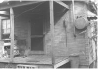
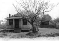
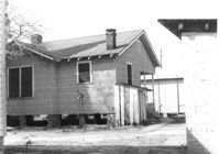
House (rear view, back porch) on site affected by the construction of Interstate 26 (I-26). Surveyor notations on back of photo: "Dkt.: 10.490. Property owner: Lillian Ferguson. Tract: 43. Station: 5799+00 Rt. Line 'G.' Date: September 12, 1962. In R/W - Bought." [See collection description for explanation of surveyor notations.]
House on site affected by the construction of Interstate 26 (I-26). [Address 2208 Delano.] Surveyor notations on back of photo: "Dkt.: 10.490. Property owner: Geo. F. Garner [George F. Garner]. Tract: 78. Station: 5822+50 Lt. Date: March 22, 1962. In R/W - Bought." [See collection description for explanation of surveyor notations.]
House on site affected by the construction of Interstate 26 (I-26). [Address 2208 Delano.] Surveyor notations on back of photo: "Dkt.: 10.490. Property owner: O.D. Tanner. Tract: 77. Station: 5822+32 Rt. Line 'G'. Date: March 22, 1962. In R/W - Bought." [See collection description for explanation of surveyor notations.]
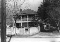
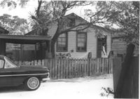
House, driveway, and shed/garage on site affected by the construction of Interstate 26 (I-26). Surveyor notations on back of photo: [Address number 2204.] "Dkt.: 10.490. Property owner: Joseph B. Cusack, Jr. Tract: 27. Station: 5820+50 Lt. Date: March 22, 1962. In R/W - Bought." [See collection description for explanation of surveyor notations.]
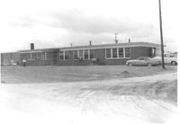
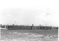
Daniel Jenkins Elementary School, on site affected by the construction of Interstate 26 (I-26). Surveyor notations on back of photo: "Dkt.: 10.490. Property owner: V.C. Chemical Co. Tract: 1. Station: 5776+00 to 5776+40 Rt. Date: September 11, 1962. To be cut off at R/W by owner." [See collection description for explanation of surveyor notations.]
Daniel Jenkins Elementary School, on site affected by the construction of Interstate 26 (I-26). Surveyor notations on back of photo: "Dkt.: 10.490. Property owner: V.C. Chemical Co. Tract: 1. Station: 5776+00 to 5776+40 Rt. Date: September 11, 1962. To be cut off at R/W by owner." [See collection description for explanation of surveyor notations.]
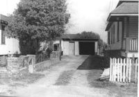
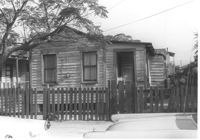
House (rear view) on site affected by the construction of Interstate 26 (I-26). [Building address number 2204.] Surveyor notations on back of photo: "Dkt.: 10.490. Property owner: Joseph B. Cusack, Jr. Tract: 27. Station: 5820+50 Lt. Date: March 22, 1962. In R/W - Bought." [See collection description for explanation of surveyor notations.]
House on site affected by the construction of Interstate 26 (I-26). (See I-26 Photo 1138, rear view.) Surveyor notations on back of photo: "Dkt.: 10.490. Property owner: Nathaniel Phoenix. Tract: 46. Station: 5799+65 Rt. Line 'G'. Date: September 11, 1962. Proximity." [See collection description for explanation of surveyor notations.]
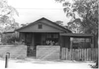
House on site affected by the construction of Interstate 26 (I-26). Surveyor notations on back of photo: "Dkt.: 10.490. Property owner: Rev. Andrew Johnson, et al. Tract: 30. Station: 5794+45 on CL Line 'A'. Date: September 11, 1962. In R/W - Bought." [See collection description for explanation of surveyor notations.]
House (rear view) on site affected by the construction of Interstate 26 (I-26). Surveyor notations on back of photo: "Dkt.: 10.490. Property owner: Anna Broderick. Tract: 31. Station: 5794+75 on CL Line 'A'. Date: September 11, 1962. In R/W - Bought." [See collection description for explanation of surveyor notations.]
House on site affected by the construction of Interstate 26 (I-26). Surveyor notations on back of photo: "Dkt.: 10.490. Property owner: Anna Broderick. Tract: 31. Station: 5794+75 on CL Line 'A'. Date: September 11, 1962. In R/W - Bought." [See collection description for explanation of surveyor notations.]
House on site affected by the construction of Interstate 26 (I-26). Surveyor notations on back of photo: "Dkt.: 10.490. Property owner: Sylvia Yaschik. Tract: 32. Station: 5795+05 on CL Line 'A'. Date: September 11, 1962. In R/W - Bought." [See collection description for explanation of surveyor notations.]
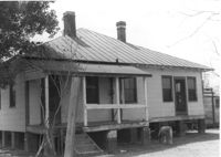
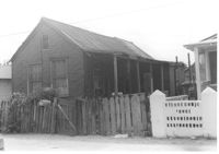
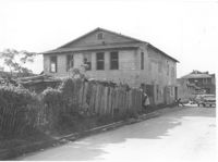
Building (rear view) on site affected by the construction of Interstate 26 (I-26). [Possibly previously a corner store with residence on second floor.] Surveyor notations on back of photo: "Dkt.: 10.490. Property owner: Robert Martin. Tract: 38. Station: 5957+45 on CL Line 'G'. Date: September 11, 1962. In R/W - Bought." [See collection description for explanation of surveyor notations.]
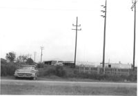
View of a row of utility poles on site affected by the construction of Interstate 26 (I-26). Charleston Plywood & Lumber Co. buildings in background. Surveyor notations on back of photo: "Dkt.: 10.490. Property owner: S.C. Electric & Gas Co. Tract: 134. Station: 5835+00 - 5835+50 Lt. Date: August 29, 1962. Camera on CL. Meters approximately 15 feet inside R/W." [See collection description for explanation of surveyor notations.]
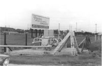
Industrial equipment on site affected by the construction of Interstate 26 (I-26). Billboard for Planters Fertilizer and Phosphate Company in background. Surveyor notations on back of photo: "Dkt.: 10.490. Property owner: Planters Fertilizer Co. Tract: 136. Station: 5843+40 Lt. Date: August 29, 1962. Moving items." [See collection description for explanation of surveyor notations.]
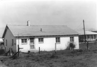
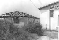
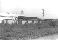
Unfinished cinder block structure next door to National Welders Supply Co., on site affected by the construction of Interstate 26 (I-26). Surveyor notations on back of photo: "Dkt.: 10.490. Property owner: Estell Stephney. Tract: 117. Station: 5830+05 Lt. Date: August 29, 1962. Rear of building to be removed by SCHD [SC Highway Department]." [See collection description for explanation of surveyor notations.]
Unfinished cinder block structure next door to National Welders Supply Co., on site affected by the construction of Interstate 26 (I-26). Surveyor notations on back of photo: "Dkt.: 10.490. Property owner: Estell Stephney. Tract: 117. Station: 5830+05 Lt. Date: August 29, 1962." [See collection description for explanation of surveyor notations.]