House (side view) on site affected by the construction of Interstate 26 (I-26). Surveyor notations on back of photo: "Dkt.: 10.490. Property owner: E.S. Lapine, et al. Tract: 60. Station: 5801+40 Rt. Line 'G'. Date: September 12, 1962. In R/W - Bought." [See collection description for explanation of surveyor notations.]
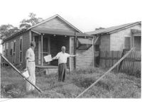
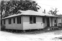
House (rear view) on site affected by the construction of Interstate 26 (I-26). Surveyor notations on back of photo: "Dkt.: 10.490. Property owner: F.F. Bellinger, et al. Tract: 48. Station: 5800+00 Rt. Line 'G'. Date: September 11, 1962. Proximity to rear." [See collection description for explanation of surveyor notations.]
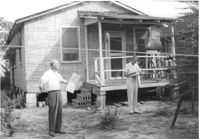
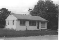
House (rear view) on site affected by the construction of Interstate 26 (I-26). Surveyor notations on back of photo: "Dkt.: 10.490. Property owner: Thomasina Goss. Tract: 47. Station: 5799+90 Rt. Line 'G'. Date: September 11, 1962. Proximity." [See collection description for explanation of surveyor notations.]
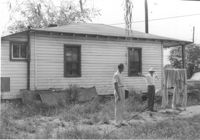
House on site affected by the construction of Interstate 26 (I-26). Surveyor notations on back of photo: "Dkt.: 10.490. Property owner: F.F. Bellinger, et al. Tract: 48. Station: 5800+00 Rt. Line 'G'. Date: September 11, 1962. Proximity." [See collection description for explanation of surveyor notations.]
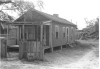
House on site affected by the construction of Interstate 26 (I-26). Surveyor notations on back of photo: "Dkt.: 10.490. Property owner: Thomasina Goss. Tract: 47. Station: 5799+90 Rt. Line 'G'. Date: September 11, 1962. Proximity." [See collection description for explanation of surveyor notations.]
House (rear view) on site affected by the construction of Interstate 26 (I-26). Address: 2167 Heriot Street. Surveyor notations on back of photo: "Dkt.: 10.490. Property owner: Louise S. Carter. Tract: 147. Station: 85' Lt. Sta. 5879+50). Date: May 15, 1962. In R/W - Bought." [See collection description for explanation of surveyor notations.]
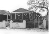
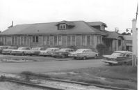
House on site affected by the construction of Interstate 26 (I-26). Surveyor notations on back of photo: "Dkt.: 10.490. Property owner: Charleston Rifle Club. Tract: 146-A. Station: 3+30 on CL of frontage road from Mechanic Street to Heriot Street. Date: September 11, 1962. In R/W - Bought." [See collection description for explanation of surveyor notations.]
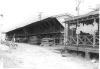
Storage structure for lumber and rear of house with laundry hanging from back porch rafter, on site affected by the construction of Interstate 26 (I-26). Address: Heriot Street. Presumably part of lumber yard. Surveyor notations on back of photo: "Dkt.: 10.490. Property owner: G.S. Carter & Son., Inc. Tract: 143. Station: 5878+40 Lt. Date: August 29, 1962. To be cut off at R/W." [See collection description for explanation of surveyor notations.]
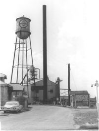
Koppers Company building and car port on site affected by the construction of Interstate 26 (I-26). Surveyor notations on back of photo: "Dkt.: 10.490. Property owner: Koppers Co. Tract: 137. Station: 5848+50 Rt. Date: August 29, 1962. To be moved by SCHD [SC Highway Department]." [See collection description for explanation of surveyor notations.]
Koppers Company building no. 21 on site affected by the construction of Interstate 26 (I-26). Surveyor notations on back of photo: "Dkt.: 10.490. Property owner: Koppers Co. Tract: 137. Station: 5847+00 Rt. Date: August 29, 1962. In R/W - Bought." [See collection description for explanation of surveyor notations.]
Koppers Company buildings and structures on site affected by the construction of Interstate 26 (I-26). Surveyor notations on back of photo: "Dkt.: 10.490. Property owner: Koppers Co. Tract: 137. Station: 5847±. Date: August 29, 1962. Guys to be relocated." [See collection description for explanation of surveyor notations.]
Koppers Company building on site affected by the construction of Interstate 26 (I-26). Surveyor notations on back of photo: "Dkt.: 10.490. Property owner: Koppers Co. Tract: 137. Station: 5848+00 on CL. Date: August 29, 1962. In R/W - Bought." [See collection description for explanation of surveyor notations.]
Koppers Company building on site affected by the construction of Interstate 26 (I-26). Surveyor notations on back of photo: "Dkt.: 10.490. Property owner: Koppers Co. Tract: 137. Station: 5848+00 on CL. Date: August 29, 1962. In R/W - Bought." [See collection description for explanation of surveyor notations.]
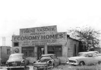
Dilapidated building on site affected by the construction of Interstate 26 (I-26). Several cars parked in front and on side of building. Painted on front facade: Eugene Yaschik Presents Economy Homes, 2323 Meeting Street Rd. Surveyor notations on back of photo: "Dkt.: 10.510. Property owner: Geo. Fabian, Jr. Tract: 67. Station: 5798+00 Lt. CL (Meeting Street). Date: Sept. 12, 1962. In R/W - Bought." [See collection description for explanation of surveyor notations.]
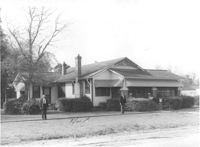
House on site affected by the construction of Interstate 26 (I-26). On Meeting Street/Meeting Street Road. Surveyor notations on back of photo: "Dkt.: 10.510. Property owner: Geo. Fabian, Jr. Tract: 67. Station: 5797+40 Lt. (Meeting Street). Date: Sept. 12, 1962. In R/W - Bought." [See collection description for explanation of surveyor notations.]
House on site affected by the widening of Route 171 (Folly Road). Surveyor notations on back of photo: "Dkt.: 10.494. Property owner: H.W. Halter, et al. Tract: 79. Station: 299+00 Rt. Date: Mar. 21, 1962. Proximity. [See collection description for explanation of surveyor notations.]
House on site affected by the widening of Route 171 (Folly Road). Surveyor notations on back of photo: "Dkt.: 10.494. Property owner: D.J. Byrd, et al. Tract: 73. Station: 280+60 Rt. Date: Mar. 21, 1962. Proximity. [See collection description for explanation of surveyor notations.]
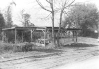
Wooden stand, on site affected by the widening of Route 171 (Folly Road). Possibly a fruit/vegetable or sweetgrass basket stand. Surveyor notations on back of photo: "Dkt.: 10.494. Property owner: Ossie Moore. Tract: 80. Station: 300+90 Rt. Date: Mar. 21, 1962. Owner to move. [See collection description for explanation of surveyor notations.]
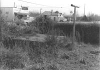
Site affected by the widening of Route 171 (Folly Road). Folly Road Pantry, B&H Grocery, and Phillips 66 gas Station: in background. Surveyor notations on back of photo: "Dkt.: 10.494. Property owner: H.W. Halter, et al. Tract: 78. Station: 298+44 Rt. Date: Mar. 21, 1962. Loss in R/W. [See collection description for explanation of surveyor notations.]
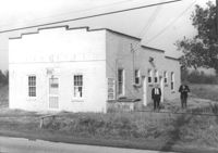
Building, on site affected by the widening of Route 171 (Folly Road). Dave Richardson and Son General Contractor. Front facade has stepped parapet. Surveyor notations on back of photo: "Dkt.: 10.494. Property owner: Dave Richardson, et al. Tract: 93. Station: 314+40 Lt. Date: Mar. 21, 1962. To be cut off at R/W by SCHD [SC Highway Department?]. [See collection description for explanation of surveyor notations.]