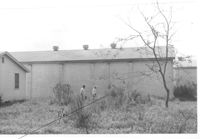
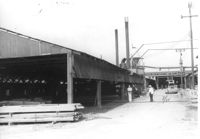
Charleston Plywood and Lumber Co. building (side view) on site affected by the construction of Interstate 26 (I-26). Surveyor notations on back of photo: "Dkt.: 10.490. Property owner: Minnie R. Sherman. Tract: 104-B. Station: 5829+20 Lt. Date: August 29, 1962. End to be moved by SCHD [SC Highway Department]." [See collection description for explanation of surveyor notations.]
Charleston Plywood and Lumber Co. building, on site affected by the construction of Interstate 26 (I-26). Surveyor notations on back of photo: "Dkt.: 10.490. Property owner: Minnie R. Sherman. Tract: 104-B. Station: 5829+20 Lt. Date: August 29, 1962. End to be moved by SCHD [SC Highway Department]." [See collection description for explanation of surveyor notations.]
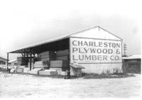
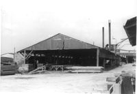
Charleston Plywood & Lumber Co. building (side view) on site affected by the construction of Interstate 26 (I-26). Surveyor notations on back of photo: "Dkt.: 10.490. Property owner: Kurco, Inc. Tract: 120, 121, 124 through 140-A and 133 through 133. Station: 5831+35 Rt. Date: August 29, 1962. Part in R/W to be moved by SCHD {SC Highway Department]." [See collection description for explanation of surveyor notations.]
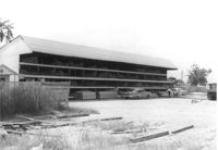
Charleston Plywood & Lumber Co. building on site affected by the construction of Interstate 26 (I-26). Surveyor notations on back of photo: "Dkt.: 10.490. Property owner: Kurco, Inc. Tract: 120, 121, 124 through 140-A and 133 through 133. Station: 5832+30 Rt. Date: August 29, 1962. Part in R/W to be moved by SCHD {SC Highway Department]." [See collection description for explanation of surveyor notations.]
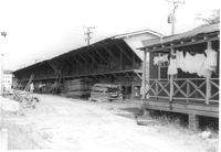
Charleston Plywood & Lumber Co. building (side view) on site affected by the construction of Interstate 26 (I-26). Surveyor notations on back of photo: "Dkt.: 10.490. Property owner: Kurco, Inc. Tract: 120, 121, 124 through 140-A and 133 through 133. Station: 5832+30 Rt. Date: August 29, 1962." [See collection description for explanation of surveyor notations.]
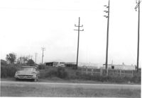
View of a row of utility poles on site affected by the construction of Interstate 26 (I-26). Charleston Plywood & Lumber Co. buildings in background. Surveyor notations on back of photo: "Dkt.: 10.490. Property owner: S.C. Electric & Gas Co. Tract: 134. Station: 5835+00 - 5835+50 Lt. Date: August 29, 1962. Camera on CL. Meters approximately 15 feet inside R/W." [See collection description for explanation of surveyor notations.]
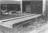
Storage structures for lumber on site affected by the construction of Interstate 26 (I-26). Address: Heriot Street. Presumably part of lumber yard. Surveyor notations on back of photo: "Dkt.: 10.490. Property owner: G.S. Carter & Son., Inc. Tract: 143. Station: 5878±. Date: August 29, 1962. In R/W - Bought." [See collection description for explanation of surveyor notations.]
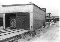
Storage structure for lumber on site affected by the construction of Interstate 26 (I-26). Address: Heriot Street. Presumably part of lumber yard. Surveyor notations on back of photo: "Dkt.: 10.490. Property owner: G.S. Carter & Son., Inc. Tract: 143. Station: 5878±. Date: August 29, 1962. To be cut off at R/W." [See collection description for explanation of surveyor notations.]
Storage structures for lumber on site affected by the construction of Interstate 26 (I-26). Address: Heriot Street. Presumably part of lumber yard. Surveyor notations on back of photo: "Dkt.: 10.490. Property owner: G.S. Carter & Son., Inc. Tract: 143. Station: 5878±. Date: August 29, 1962. To be cut off at R/W." [See collection description for explanation of surveyor notations.]
Storage structure for lumber and other structure (for lumber processing?) on site affected by the construction of Interstate 26 (I-26). Address: Heriot Street. Presumably part of lumber yard. Surveyor notations on back of photo: "Dkt.: 10.490. Property owner: G.S. Carter & Son., Inc. Tract: 143. Station: 5878±. Date: August 29, 1962. To be cut off at R/W." [See collection description for explanation of surveyor notations.]
Storage structure for lumber and other structure (lumber processing?) on site affected by the construction of Interstate 26 (I-26). Address: Heriot Street. Presumably part of lumber yard. Surveyor notations on back of photo: "Dkt.: 10.490. Property owner: G.S. Carter & Son., Inc. Tract: 143. Station: 5878±. Date: August 29, 1962. To be cut off at R/W." [See collection description for explanation of surveyor notations.]
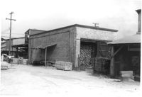
Storage structure for lumber and rear of house with laundry hanging from back porch rafter, on site affected by the construction of Interstate 26 (I-26). Address: Heriot Street. Presumably part of lumber yard. Surveyor notations on back of photo: "Dkt.: 10.490. Property owner: G.S. Carter & Son., Inc. Tract: 143. Station: 5878+40 Lt. Date: August 29, 1962. To be cut off at R/W." [See collection description for explanation of surveyor notations.]