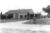
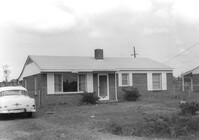
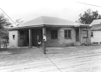
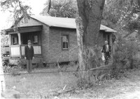
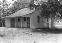
House on site affected by the construction of Interstate 26 (I-26). Building address number 35. Surveyor notations on back of photo: "Dkt.: 10.480. Property owner: Mrs. Helen S. Shuler. Tract: 291. Station: 5738+50 CL Main Line. Date: May 30, 1961. In R/W - Bought." [See collection description for explanation of surveyor notations.]
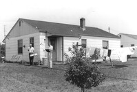
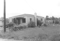
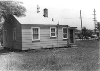
House (corner view, rear) on site affected by the construction of Interstate 26 (I-26). Surveyor notations on back of photo: "Dkt.: 10.480. Property owner: Mrs. Evelyn R. King. Tract: 288. Station: 5738+80 Lt. (Line B). Date: May 30, 1961. Proximity." [See collection description for explanation of surveyor notations.]
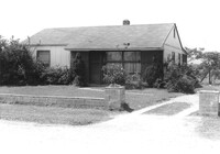
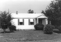
House on site affected by the construction of Interstate 26 (I-26). Surveyor notations on back of photo: "Dkt.: 10.480. Property owner: Mrs. Evelyn R. King. Tract: 288. Station: 5738+80 Lt. (Line B). Date: May 30, 1961. Proximity." [See collection description for explanation of surveyor notations.]
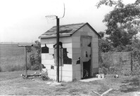
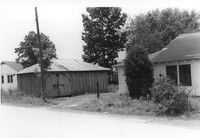
Small shed on site affected by the construction of Interstate 26 (I-26). Surveyor notations on back of photo: "Dkt.: 10.480. Property owner: Harold W. Cone. Tract: 285. Station: 5734+10 Lt. (Line B). Date: May 30, 1961. In R/W - Bought." [See collection description for explanation of surveyor notations.]
Shed on site affected by the construction of Interstate 26 (I-26). Surveyor notations on back of photo: "Dkt.: 10.480. Property owner: Ruth I. Kirby. Tract: 236. Station: 5699+30 Lt. Date: May 2, 1961. In R/W - Bought." [See collection description for explanation of surveyor notations.]
House on site affected by the construction of Interstate 26 (I-26). Sign over window: Pat's TV and Radio Repair. Surveyor notations on back of photo: "Dkt.: 10.480. Property owner: Boyd E. Patterson. Tract: 153. Station: 5666+80 Rt. Date: May 2, 1961. In R/W - Bought." [See collection description for explanation of surveyor notations.]
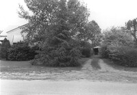
House on site affected by the construction of Interstate 26 (I-26). Obscured by trees. Garage/shed at end of driveway. Surveyor notations on back of photo: "Dkt.: 10.480. Property owner: Edward P. Blanton. Tract: 146. Station: 5661+30 Rt. Date: May 2, 1961. In R/W - Bought." [See collection description for explanation of surveyor notations.]
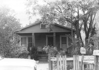
House on site affected by the construction of Interstate 26 (I-26). Royal Crown Cola sign on fence. Surveyor notations on back of photo: "Dkt.: 10.480. Property owner: Central McMillan, et al. Tract: 38. Station: 5508+40 Rt. Date: May 2, 1961. In R/W - Bought." [See collection description for explanation of surveyor notations.]
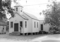
Enah Chapel Church on site affected by the construction of Interstate 26 (I-26). Surveyor notations on back of photo: "Dkt.: 10.480. Property owner: Enoch Methodist Church. Tract: 36. Station: 5507+80 Lt. Date: May 2, 1961. In R/W - Bought." [See collection description for explanation of surveyor notations.]
House on site affected by the construction of Interstate 26 (I-26). Surveyor notations on back of photo: "Dkt.: 10.480. Property owner: Joseph Perry. Tract: 34. Station: 5507+10 Lt. Date: May 2, 1961. In R/W - Bought." [See collection description for explanation of surveyor notations.]
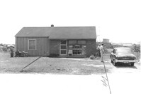
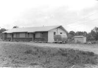
House on site affected by the construction of Interstate 26 (I-26). Building address number 105. Surveyor notations on back of photo: "Dkt.: 10.480. Property owner: Norman Lubesky. Tract: 284. Station: 5733+50 Lt. (Line B). Date: May 30, 1961. In R/W - Bought." [See collection description for explanation of surveyor notations.]
House, possibly duplex, on site affected by the construction of Interstate 26 (I-26). Surveyor notations on back of photo: "Dkt.: 10.480. Property owner: Roy A. Farley, et al. Tract: 102-A. Station: 55+60 Lt. (Goodrich Road). Date: May 2, 1961. Proximity." [See collection description for explanation of surveyor notations.]
House on site affected by the construction of Interstate 26 (I-26). Outbuilding in background. Surveyor notations on back of photo: "Dkt.: 10.480. Property owner: Rosa Bell Harley. Tract: 83. Station: 5521+80 Rt. Date: May 2, 1961. In R/W - Bought." [See collection description for explanation of surveyor notations.]
House on site affected by the construction of Interstate 26 (I-26). Surveyor notations on back of photo: "Dkt.: 10.480. Property owner: Joe Stephens, Est. Tract: 29. Station: 5506+00 Lt. Date: May 1, 1961. In R/W - Bought." [See collection description for explanation of surveyor notations.]
House on site affected by the construction of Interstate 26 (I-26). Surveyor notations on back of photo: "Dkt.: 10.480. Property owner: Evelyn Nelson. Tract: 80. Station: 5519+30 Rt. Date: May 2, 1961. In R/W - Bought." [See collection description for explanation of surveyor notations.]
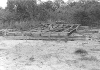
Pile of wood framing on lot, on site affected by the construction of Interstate 26 (I-26). Surveyor notations on back of photo: "Dkt.: 10.480. Property owner: Williams Furniture Co., et al. Tract: 103-B. Station: 5583+55 Rt. Date: May 2, 1961. In R/W - Bought." [See collection description for explanation of surveyor notations.]
House (rear view?) and structure (garage or shed) on site affected by the construction of Interstate 26 (I-26). Building address number 1800. Possibly on Rivers Avenue. Surveyor notations on back of photo: "Dkt.: 10.486. Property owner: G.P. Parris, Est. Tract: 6. Station: 9+50 Lt. Date: May 30, 1961. In R/W - Bought." [See collection description for explanation of surveyor notations.]
House (corner view, rear) on site affected by the construction of Interstate 26 (I-26). Building address number 1806. Possibly on Rivers Avenue. Surveyor notations on back of photo: "Dkt.: 10.486. Property owner: Cleve G. Murray. Tract: 12. Station: 10+90 Lt. Date: May 30, 1961. In R/W - Bought." [See collection description for explanation of surveyor notations.]
House on site affected by the construction of Interstate 26 (I-26). Piggly Wiggly store across the street, in background. Possibly on Rivers Avenue. Surveyor notations on back of photo: "Dkt.: 10.486. Property owner: Mrs. Hazel Faulkner. Tract: 9. Station: 10+35 Lt. Date: May 30, 1961. In R/W - Bought." [See collection description for explanation of surveyor notations.]
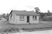
House on site affected by the construction of Interstate 26 (I-26). Surveyor notations on back of photo: "Dkt.: 10.480. Property owner: Herbert Jones. Tract: 192. Station: 5687+00 Lt. Date: May 31, 1961. In R/W - Bought." [See collection description for explanation of surveyor notations.]