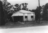
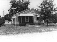
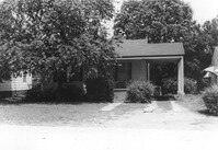
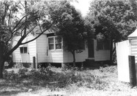
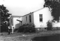
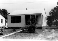
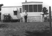
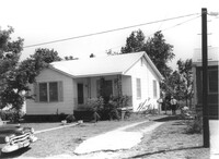
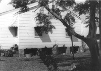
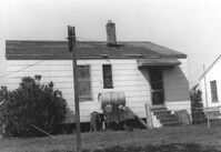
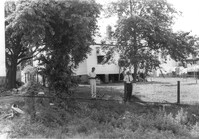
House on site affected by the construction of Interstate 26 (I-26). Surveyor notations on back of photo: "Dkt.: 10.480. Property owner: William A. Graham. Tract: 239. Station: 5701+00 Lt. Date: May 31, 1961. In R/W - Bought." [See collection description for explanation of surveyor notations.]
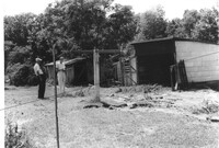
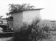
Wooden structure (possibly garage, shed, barn) on site affected by the construction of Interstate 26 (I-26). Surveyor notations on back of photo: "Dkt.: 10.480. Property owner: William A. Graham. Tract: 239. Station: 5701+00 Lt. Date: May 31, 1961. In R/W - Bought." [See collection description for explanation of surveyor notations.]
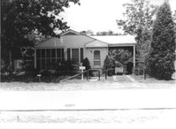
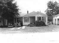
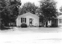
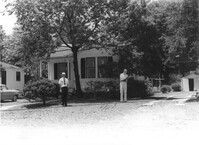
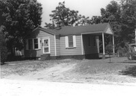
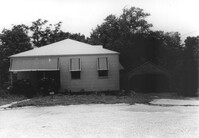
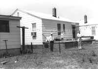
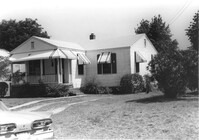
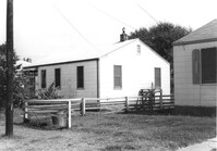
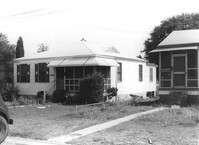
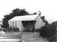
House on site affected by the construction of Interstate 26 (I-26). Building address number 70. Surveyor notations on back of photo: "Dkt.: 10.480. Property owner: James Menke Jr. Tract: 240. Station: 5701+60 Lt. Date: May 31, 1961. In R/W - Bought." [See collection description for explanation of surveyor notations.]
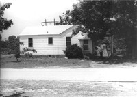
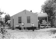
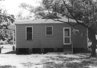
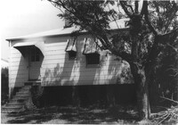
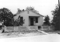
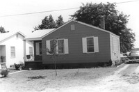
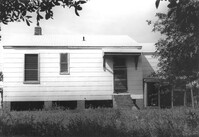
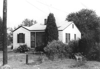
House on site affected by the construction of Interstate 26 (I-26). Surveyor notations on back of photo: "Dkt.: 10.480. Property owner: Mrs. Margaret H. Patterson. Tract: 241. Station: 5702+10 Lt. Date: May 31, 1961. In R/W - Bought." [See collection description for explanation of surveyor notations.]
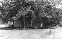
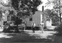
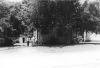
Cinderblock structure on site affected by the construction of Interstate 26 (I-26). Obscured by trees. Surveyor notations on back of photo: "Dkt.: 10.480. Property owner: Mrs. Margaret H. Patterson. Tract: 241. Station: 5702+60 Lt. Date: May 31, 1961. In R/W - Bought." [See collection description for explanation of surveyor notations.]
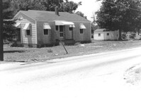
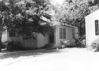
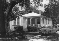
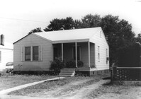
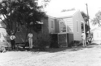
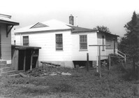
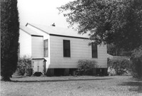
House on site affected by the construction of Interstate 26 (I-26). Building address number 80. Surveyor notations on back of photo: "Dkt.: 10.480. Property owner: William F. Carter. Tract: 243. Station: 5704+85 Rt. Date: May 31, 1961. In R/W - Bought." [See collection description for explanation of surveyor notations.]
House on site affected by the construction of Interstate 26 (I-26). Building address number 80. Surveyor notations on back of photo: "Dkt.: 10.480. Property owner: William F. Carter. Tract: 243. Station: 5704+85 Rt. Date: May 31, 1961. In R/W - Bought." [See collection description for explanation of surveyor notations.]
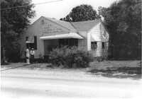
House on site affected by the construction of Interstate 26 (I-26). Surveyor notations on back of photo: "Dkt.: 10.480. Property owner: The Beach Company. Tract: 244. Station: 5705+35 Rt. Date: May 31, 1961. In R/W - Bought." [See collection description for explanation of surveyor notations.]
House (side view) on site affected by the construction of Interstate 26 (I-26). Surveyor notations on back of photo: "Dkt.: 10.480. Property owner: The Beach Company. Tract: 244. Station: 5705+35 Rt. Date: May 31, 1961. In R/W - Bought." [See collection description for explanation of surveyor notations.]
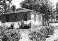
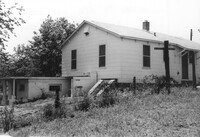
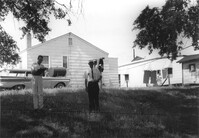
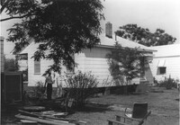
House (corner view, rear) on site affected by the construction of Interstate 26 (I-26). Surveyor notations on back of photo: "Dkt.: 10.480. Property owner: James H. Black. Tract: 245. Station: 5705+60 Rt. Date: May 31, 1961. In R/W - Bought." [See collection description for explanation of surveyor notations.]
House on site affected by the construction of Interstate 26 (I-26). Surveyor notations on back of photo: "Dkt.: 10.480. Property owner: James H. Black. Tract: 245. Station: 5705+60 Rt. Date: May 31, 1961. In R/W - Bought." [See collection description for explanation of surveyor notations.]
House on site affected by the construction of Interstate 26 (I-26). Obscured by shadows and tree. Surveyor notations on back of photo: "Dkt.: 10.480. Property owner: James R. & Elanor P. Cooper. Tract: 246. Station: 5706+00 Rt. Date: May 31, 1961. In R/W - Bought." [See collection description for explanation of surveyor notations.]
House on site affected by the construction of Interstate 26 (I-26). Surveyor notations on back of photo: "Dkt.: 10.480. Property owner: James R. & Elanor P. Cooper. Tract: 246. Station: 5706+00 Rt. Date: May 31, 1961. In R/W - Bought." [See collection description for explanation of surveyor notations.]
House (corner view, rear) on site affected by the construction of Interstate 26 (I-26). Surveyor notations on back of photo: "Dkt.: 10.480. Property owner: James R. & Elanor P. Cooper. Tract: 246. Station: 5706+00 Rt. Date: May 31, 1961. In R/W - Bought." [See collection description for explanation of surveyor notations.]
House on site affected by the construction of Interstate 26 (I-26). Surveyor notations on back of photo: "Dkt.: 10.480. Property owner: J.P. Harvey. Tract: 247. Station: 5706+85 Rt. Date: May 31, 1961. Proximity." [See collection description for explanation of surveyor notations.]
House on site affected by the construction of Interstate 26 (I-26). Surveyor notations on back of photo: "Dkt.: 10.480. Property owner: Florence K. Byfield. Tract: 248. Station: 5705+40 Lt. Date: May 31, 1961. In R/W - Bought." [See collection description for explanation of surveyor notations.]
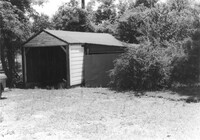
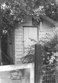
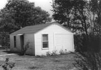
Garage/shed on site affected by the construction of Interstate 26 (I-26). Surveyor notations on back of photo: "Dkt.: 10.480. Property owner: Florence K. Byfield. Tract: 248. Station: 5705+40 Lt. Date: May 31, 1961. In R/W - Bought." [See collection description for explanation of surveyor notations.]
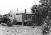
House (rear view) on site affected by the construction of Interstate 26 (I-26). Surveyor notations on back of photo: "Dkt.: 10.480. Property owner: Florence K. Byfield. Tract: 248. Station: 5705+40 Lt. Date: May 31, 1961. In R/W - Bought." [See collection description for explanation of surveyor notations.]
House on site affected by the construction of Interstate 26 (I-26). Partially obscured by trees. Surveyor notations on back of photo: "Dkt.: 10.480. Property owner: C.H. & Elise V. Meidburg. Tract: 249. Station: 5705+80 Lt. Date: May 31, 1961. In R/W - Bought." [See collection description for explanation of surveyor notations.]
Shed on site affected by the construction of Interstate 26 (I-26). Surveyor notations on back of photo: "Dkt.: 10.480. Property owner: C.H. & Elise V. Meidburg. Tract: 249. Station: 5705+80 Lt. Date: May 31, 1961. In R/W - Bought." [See collection description for explanation of surveyor notations.]
House on site affected by the construction of Interstate 26 (I-26). Partially obscured by trees. Surveyor notations on back of photo: "Dkt.: 10.480. Property owner: C.G. Hudson. Tract: 250. Station: 5706+30 Lt. Date: May 31, 1961. In R/W - Bought." [See collection description for explanation of surveyor notations.]
Sheds in dilapidated condition on site affected by the construction of Interstate 26 (I-26). Surveyor notations on back of photo: "Dkt.: 10.480. Property owner: C.G. Hudson. Tract: 250. Station: 5706+30 Lt. Date: May 31, 1961. In R/W - Bought." [See collection description for explanation of surveyor notations.]
House (corner view, rear) on site affected by the construction of Interstate 26 (I-26). Partially obscured by trees. Surveyor notations on back of photo: "Dkt.: 10.480. Property owner: C.G. Hudson. Tract: 250. Station: 5706+30 Lt. Date: May 31, 1961. In R/W - Bought." [See collection description for explanation of surveyor notations.]
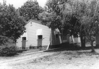
House on site affected by the construction of Interstate 26 (I-26). Surveyor notations on back of photo: "Dkt.: 10.480. Property owner: C.G. Hudson. Tract: 251. Station: 5706+70 Lt. Date: May 31, 1961. In R/W - Bought." [See collection description for explanation of surveyor notations.]
House (rear view) on site affected by the construction of Interstate 26 (I-26). Surveyor notations on back of photo: "Dkt.: 10.480. Property owner: C.G. Hudson. Tract: 251. Station: 5706+70 Lt. Date: May 31, 1961. In R/W - Bought." [See collection description for explanation of surveyor notations.]
House on site affected by the construction of Interstate 26 (I-26). Surveyor notations on back of photo: "Dkt.: 10.480. Property owner: Juanita Miller. Tract: 252. Station: 5705+15 Rt. Date: May 31, 1961. In R/W - Bought." [See collection description for explanation of surveyor notations.]
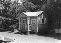
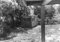
Child's playhouse or small guest house, on site affected by the construction of Interstate 26 (I-26). Surveyor notations on back of photo: "Dkt.: 10.480. Property owner: Juanita Miller. Tract: 252. Station: 5707+65 Rt. Date: May 31, 1961. In R/W - Bought." [See collection description for explanation of surveyor notations.]
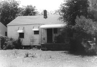
House (rear view) on site affected by the construction of Interstate 26 (I-26). Surveyor notations on back of photo: "Dkt.: 10.480. Property owner: Juanita Miller. Tract: 252. Station: 5705+15 Rt. Date: May 31, 1961. In R/W - Bought." [See collection description for explanation of surveyor notations.]
House on site affected by the construction of Interstate 26 (I-26). Surveyor notations on back of photo: "Dkt.: 10.480. Property owner: Mouzon Taylor. Tract: 253. Station: 5707+55 Rt. Date: May 31, 1961. In R/W - Bought." [See collection description for explanation of surveyor notations.]
House (side view) on site affected by the construction of Interstate 26 (I-26). Surveyor notations on back of photo: "Dkt.: 10.480. Property owner: Mouzon Taylor. Tract: 253. Station: 5707+55 Rt. Date: May 31, 1961. In R/W - Bought." [See collection description for explanation of surveyor notations.]
House on site affected by the construction of Interstate 26 (I-26). Surveyor notations on back of photo: "Dkt.: 10.480. Property owner: Fred S. Saulters. Tract: 259. Station: 5712+45 Lt. Date: May 31, 1961. In R/W - Bought." [See collection description for explanation of surveyor notations.]
House (corner view, rear) on site affected by the construction of Interstate 26 (I-26). Surveyor notations on back of photo: "Dkt.: 10.480. Property owner: Fred S. Saulters. Tract: 259. Station: 5712+45 Lt. Date: May 31, 1961. In R/W - Bought." [See collection description for explanation of surveyor notations.]
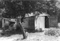
Sheds in dilapidated condition and yard on site affected by the construction of Interstate 26 (I-26). Surveyor notations on back of photo: "Dkt.: 10.480. Property owner: Fred S. Saulters. Tract: 259. Station: 5711+85 Lt. Date: May 31, 1961. Bought." [See collection description for explanation of surveyor notations.]
House on site affected by the construction of Interstate 26 (I-26). Surveyor notations on back of photo: "Dkt.: 10.480. Property owner: Mrs. Sarah Elise P. Ford Thompson. Tract: 260. Station: 5712+20 Lt. Date: May 31, 1961. In R/W - Bought." [See collection description for explanation of surveyor notations.]
House (rear view) on site affected by the construction of Interstate 26 (I-26). Surveyor notations on back of photo: "Dkt.: 10.480. Property owner: Mrs. Sarah Elise P. Ford Thompson. Tract: 260. Station: 5712+20 Lt. Date: May 31, 1961. In R/W - Bought." [See collection description for explanation of surveyor notations.]
House on site affected by the construction of Interstate 26 (I-26). Building address number 185. Surveyor notations on back of photo: "Dkt.: 10.480. Property owner: Janet H. & Robert Carl Wilson. Tract: 262. Station: 5713+50 Lt. Date: May 31, 1961. In R/W - Bought." [See collection description for explanation of surveyor notations.]
House (corner view, rear) on site affected by the construction of Interstate 26 (I-26). [Building address number 185.] Surveyor notations on back of photo: "Dkt.: 10.480. Property owner: Janet H. & Robert Carl Wilson. Tract: 262. Station: 5713+50 Lt. Date: May 31, 1961. In R/W - Bought." [See collection description for explanation of surveyor notations.]
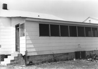
Small cinderblock structure (shed?) on site affected by the construction of Interstate 26 (I-26). [Building address number 185.] Surveyor notations on back of photo: "Dkt.: 10.480. Property owner: Janet H. & Robert Carl Wilson. Tract: 262. Station: 5713+50 Lt. Date: May 31, 1961. In R/W - Bought." [See collection description for explanation of surveyor notations.]
House (corner view, rear) on site affected by the construction of Interstate 26 (I-26). Surveyor notations on back of photo: "Dkt.: 10.480. Property owner: D.T. Browning. Tract: 263. Station: 5713+85 Lt. Date: May 31, 1961. In R/W - Bought." [See collection description for explanation of surveyor notations.]
House on site affected by the construction of Interstate 26 (I-26). Surveyor notations on back of photo: "Dkt.: 10.480. Property owner: D.T. Browning. Tract: 263. Station: 5713+85 Lt. Date: May 31, 1961. In R/W - Bought." [See collection description for explanation of surveyor notations.]
House on site affected by the construction of Interstate 26 (I-26). Surveyor notations on back of photo: "Dkt.: 10.480. Property owner: D.T. Browning. Tract: 264. Station: 5714+20 Lt. Date: May 31, 1961. In R/W - Bought." [See collection description for explanation of surveyor notations.]
House (side view?) on site affected by the construction of Interstate 26 (I-26). Surveyor notations on back of photo: "Dkt.: 10.480. Property owner: D.T. Browning. Tract: 264. Station: 5714+20 Lt. Date: May 31, 1961. In R/W - Bought." [See collection description for explanation of surveyor notations.]
House (rear view) on site affected by the construction of Interstate 26 (I-26). Surveyor notations on back of photo: "Dkt.: 10.480. Property owner: D.T. Browning. Tract: 264. Station: 5714+60 Lt. Date: May 31, 1961. In R/W - Bought." [See collection description for explanation of surveyor notations.]
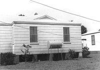
Cinderblock structure and doghouse, on site affected by the construction of Interstate 26 (I-26). Surveyor notations on back of photo: "Dkt.: 10.480. Property owner: D.T. Browning. Tract: 264. Station: 5714+60 Lt. Date: May 31, 1961. In R/W - Bought." [See collection description for explanation of surveyor notations.]
House (rear view) on site affected by the construction of Interstate 26 (I-26). Surveyor notations on back of photo: "Dkt.: 10.480. Property owner: John J. & Yolanda W. Houton. Tract: 265. Station: 5714+55 Lt. Date: May 31, 1961. Proximity." [See collection description for explanation of surveyor notations.]
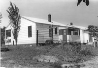
House on site affected by the construction of Interstate 26 (I-26). Surveyor notations on back of photo: "Dkt.: 10.480. Property owner: John J. & Yolanda W. Houton. Tract: 265. Station: 5714+55 Lt. Date: May 31, 1961. In R/W - Bought." [See collection description for explanation of surveyor notations.]
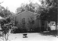
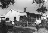
House (rear view) and yard, on site affected by the construction of Interstate 26 (I-26). Surveyor notations on back of photo: "Dkt.: 10.480. Property owner: Matthew J. & Winifred C. Polutto. Tract: 266. Station: 5715+00 Lt. Date: May 31, 1961. Proximity." [See collection description for explanation of surveyor notations.]
House (rear view) on site affected by the construction of Interstate 26 (I-26). Surveyor notations on back of photo: "Dkt.: 10.480. Property owner: Woodrow W. Wade. Tract: 268. Station: 5723+40 Lt. (Line C). Date: May 31, 1961. Proximity." [See collection description for explanation of surveyor notations.]
House (rear view) on site affected by the construction of Interstate 26 (I-26). [Building address number 145.] Surveyor notations on back of photo: "Dkt.: 10.480. Property owner: Jerome M. Williams. Tract: 270. Station: 5724+10 Lt. (Line C). Date: May 31, 1961. Proximity." [See collection description for explanation of surveyor notations.]
House on site affected by the construction of Interstate 26 (I-26). Building address number 145. Surveyor notations on back of photo: "Dkt.: 10.480. Property owner: Jerome M. Williams. Tract: 270. Station: 5724+10 Lt. (Line C). Date: May 31, 1961. Proximity." [See collection description for explanation of surveyor notations.]
House on site affected by the construction of Interstate 26 (I-26). Surveyor notations on back of photo: "Dkt.: 10.480. Property owner: Willie M. Burbage. Tract: 271. Station: 5724+60 Lt. Date: May 31, 1961. Proximity." [See collection description for explanation of surveyor notations.]
House (corner view, rear) on site affected by the construction of Interstate 26 (I-26). Surveyor notations on back of photo: "Dkt.: 10.480. Property owner: Willie M. Burbage. Tract: 271. Station: 5724+60 Lt. (Line C) Date: May 31, 1961. Proximity." [See collection description for explanation of surveyor notations.]
House on site affected by the construction of Interstate 26 (I-26). Surveyor notations on back of photo: "Dkt.: 10.480. Property owner: Jessie L. & Doris S. Bercaw. Tract: 272. Station: 5725±Lt. (Line C). Date: May 31, 1961. In R/W - Bought." [See collection description for explanation of surveyor notations.]
House (corner view, rear) on site affected by the construction of Interstate 26 (I-26). Surveyor notations on back of photo: "Dkt.: 10.480. Property owner: Jessie L. & Doris S. Bercaw. Tract: 272. Station: 5725+00 Lt. (Line C). Date: May 31, 1961. In R/W - Bought." [See collection description for explanation of surveyor notations.]
Guesthouse? on site affected by the construction of Interstate 26 (I-26). Surveyor notations on back of photo: "Dkt.: 10.480. Property owner: Jessie L. & Doris S. Bercaw. Tract: 272. Station: 5724+85 Rt. (Line C). Date: May 31, 1961. In R/W - Bought." [See collection description for explanation of surveyor notations.]
House on site affected by the construction of Interstate 26 (I-26). Surveyor notations on back of photo: "Dkt.: 10.480. Property owner: William J. Thrift Jr. Tract: 273. Station: 5725+40 on CL (Line C). Date: May 31, 1961. In R/W - Bought." [See collection description for explanation of surveyor notations.]
House (rear view) on site affected by the construction of Interstate 26 (I-26). Surveyor notations on back of photo: "Dkt.: 10.480. Property owner: William J. Thrift Jr. Tract: 273. Station: 5725+40 on CL (Line C). Date: May 31, 1961. In R/W - Bought." [See collection description for explanation of surveyor notations.]
House (corner view, rear) on site affected by the construction of Interstate 26 (I-26). Surveyor notations on back of photo: "Dkt.: 10.480. Property owner: H.L. DuPuis Sr. Tract: 274. Station: 5725+90 Rt. (Line C). Date: May 31, 1961. In R/W - Bought." [See collection description for explanation of surveyor notations.]
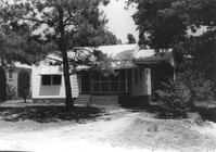
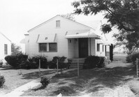
House on site affected by the construction of Interstate 26 (I-26). Surveyor notations on back of photo: "Dkt.: 10.480. Property owner: H.L. DuPuis Sr. Tract: 274. Station: 5725+90 Rt. (Line C). Date: May 31, 1961. In R/W - Bought." [See collection description for explanation of surveyor notations.]
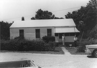
House on site affected by the construction of Interstate 26 (I-26). Surveyor notations on back of photo: "Dkt.: 10.480. Property owner: William R. Hankins. Tract: 275. Station: 5726+40 Rt. (Line C). Date: May 31, 1961. In R/W - Bought." [See collection description for explanation of surveyor notations.]
House (rear view) on site affected by the construction of Interstate 26 (I-26). Surveyor notations on back of photo: "Dkt.: 10.480. Property owner: William R. Hankins. Tract: 275. Station: 5726+40 Rt. (Line C). Date: May 31, 1961. In R/W - Bought." [See collection description for explanation of surveyor notations.]
House (corner view, rear) on site affected by the construction of Interstate 26 (I-26). Surveyor notations on back of photo: "Dkt.: 10.480. Property owner: J.E. Kitchins Sr. & Jr. Tract: 276. Station: 5726+90 Rt. (Line C). Date: May 31, 1961. In R/W - Bought." [See collection description for explanation of surveyor notations.]
House (rear view) on site affected by the construction of Interstate 26 (I-26). Surveyor notations on back of photo: "Dkt.: 10.480. Property owner: J.E. Kitchins Sr. & Jr. Tract: 276. Station: 5726+90 Rt. (Line C). Date: May 31, 1961. In R/W - Bought." [See collection description for explanation of surveyor notations.]
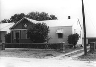
House (corner view, rear) on site affected by the construction of Interstate 26 (I-26). [Building address number 131). Surveyor notations on back of photo: "Dkt.: 10.480. Property owner: Minnie L. Geiger. Tract: 277. Station: 5725+40 Rt. (Line C). Date: May 31, 1961. In R/W - Bought." [See collection description for explanation of surveyor notations.]
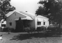
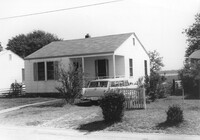
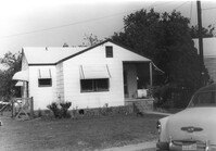
House on site affected by the construction of Interstate 26 (I-26). Building address number 131. Surveyor notations on back of photo: "Dkt.: 10.480. Property owner: Minnie L. Geiger. Tract: 277. Station: 5725+40 Rt. (Line C). Date: May 31, 1961. In R/W - Bought." [See collection description for explanation of surveyor notations.]
Sheds and old car, on site affected by the construction of Interstate 26 (I-26). [Building address number 131.] Surveyor notations on back of photo: "Dkt.: 10.480. Property owner: Minnie L. Geiger. Tract: 277. Station: 5726+80 Rt. (Line C). Date: May 31, 1961. In R/W - Bought." [See collection description for explanation of surveyor notations.]
House on site affected by the construction of Interstate 26 (I-26). Surveyor notations on back of photo: "Dkt.: 10.480. Property owner: H.L. DuPuis Jr. Tract: 278. Station: 5728+00 Rt. (Line C). Date: May 31, 1961. In R/W - Bought." [See collection description for explanation of surveyor notations.]
House (rear view) on site affected by the construction of Interstate 26 (I-26). Surveyor notations on back of photo: "Dkt.: 10.480. Property owner: H.L. DuPuis Jr. Tract: 278. Station: 5728+00 Rt. (Line C). Date: May 31, 1961. In R/W - Bought." [See collection description for explanation of surveyor notations.]
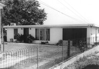
House on site affected by the construction of Interstate 26 (I-26). Surveyor notations on back of photo: "Dkt.: 10.480. Property owner: William C. Minter. Tract: 279. Station: 5728+65 Lt. (Line C). Date: May 31, 1961. In R/W - Bought." [See collection description for explanation of surveyor notations.]
House (corner view, rear) on site affected by the construction of Interstate 26 (I-26). Surveyor notations on back of photo: "Dkt.: 10.480. Property owner: William C. Minter. Tract: 279. Station: 5728+65 Lt. (Line C). Date: May 31, 1961. In R/W - Bought." [See collection description for explanation of surveyor notations.]
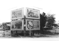
Billboards on lot, on site affected by the construction of Interstate 26 (I-26). Life Insurance Company of Georgia, Sprite, Phillips 66, and FLIT. Surveyor notations on back of photo: "Dkt.: 10.480. Property owner: William C. Minter. Tract: 279. Station: [unknown/unidentified]. Date: May 31, 1961. For information only." [See collection description for explanation of surveyor notations.]
House on site affected by the construction of Interstate 26 (I-26). Surveyor notations on back of photo: "Dkt.: 10.480. Property owner: Mrs. Lila Hutto. Tract: 280. Station: 5729+00 Lt. (Line C). Date: May 31, 1961. Proximity." [See collection description for explanation of surveyor notations.]
House (rear view) and yard, on site affected by the construction of Interstate 26 (I-26). Surveyor notations on back of photo: "Dkt.: 10.480. Property owner: Mrs. Lila Hutto. Tract: 280. Station: 5729+00 Lt. (Line C). Date: May 31, 1961. Proximity." [See collection description for explanation of surveyor notations.]
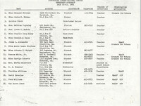
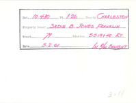
Example of information written on back of photograph: Docket Number, Route, County, Property Owner, Tract, Station, Date, and added note pertaining to right-of-way.
Newspaper printed for the civilian employees of the Charleston Naval Shipyard starting on January 6th 1961. This volume covers from January 6th 1961 to December 29rd 1961.
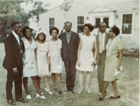
Photograph of eight members of Avery's class of 1931 reunited after thirty years at a classmate's wedding. All are dressed up and stand outside of a church.
Correspondence from Bernice V. Robinson to the Highlander Staff regarding the Report of the Training Leaders for Citizenship Schools, July 17 to 23, 1961.
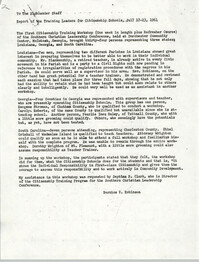
Example of information written on back of photograph: Docket Number, Route, County, Property Owner, Tract, Station, Date, and added note pertaining to right-of-way.
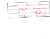
Example of information written on back of photograph: Docket Number, Route, County, Property Owner, Tract, Station, Date, and added note pertaining to right-of-way.
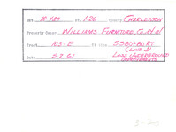
Example of information written on back of photograph: Docket Number, Route, County, Property Owner, Tract, Station, Date, and added note pertaining to right-of-way.
Compilation of original deeds, titles, and other documents related to the transfer, sale, and ownership of the double tenement at 72-74 Tradd Street, known as the Fotheringham-McNeil Tenements. Documents span from 1765 to 1961, likely representing the entire history of the ownership of the double tenement throughout that time period. Also includes blueprints and photographs. (NOTE: Fotheringham has also been spelled Fotheringham.)
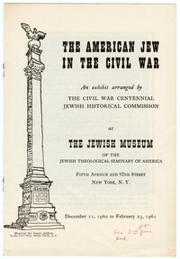
A pamphlet for an exhibit on Jewish participation in the Civil War. Includes a brief overview of the exhibit, a map of Jewish communities in the United States during the Civil War, lists of organizations and individuals who contributed to the exhibit, and a list of objects in the exhibit.


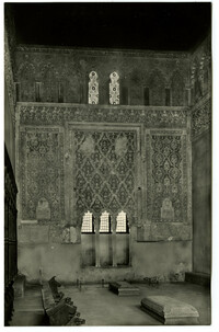
![[Ben Ezra Synagogue, Cairo]](https://rspace.library.cofc.edu/iiif/image/47345/full/200,/0/default.jpg)