Page 257 of the City Engineer's Plat Book with two plats. Plat 1 shows lots located between St. Margaret Street and Grove Street. Plat 2 shows lots located along Marsh Street and Concord Street, near where they intersect with Laurens Street.
A report from the mayor, city council, and various governmental departments of Charleston, S.C. for the year 1926. ??The Year Book opens with an address from the mayor, Thomas P. Stoney, followed by reports from various departments.
The College of Charleston Magazine is a monthly publication released by the College of Charleston's Chrestomathic Society during the academic year. This volume is comprised of the bound together publications from the months of November 1926-April 1927. The volume is missing pages 117-122 of Vol. XXX No. 4.
“Stories Collected from Slaves” by Leonarda J. Aimar is a bound volume of formerly enslaved people's stories. In her transcription, she attempted to capture the storytellers’ colloquial speech, now recognized as the Gullah language. The volume includes a list of addresses, occupations, and diseases of African Americans during their enslavement; an eye-witness account of the Battle of Secessionville on James Island during the Civil War in 1862; how enslaved people were returned to their slaveholders following the Revolutionary War; and an account of Sherman's march from Savannah, Georgia to Charleston, South Carolina during the Civil War. A formerly enslaved man, Sam, provides a detailed account of being a butler, coachman, and horse jockey. He also recounts how Union Army Major Robert Anderson took control of Fort Sumter and the events that transpired there on April 12, 1861. Other accounts include an enslaved man’s recollections of his time as a servant to a plantation overseer who sympathized with the Union during the Civil War and formerly enslaved man Jim Alston’s detailed eye-witness account of the 1876 Cainhoy Riot.
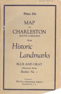
Map of the Charleston peninsula featuring points of interest. Cover title: Map of Charleston, South Carolina with historic landmarks. Blue and gray historical series, booklet no. 1. Published by Wil-Tuc Advertising Agency. Map measures 21” x 6.25” folded to create 13 pages measuring 6.25” x 3.5.