Department of the Interior Bureau of Education leaflet, "Civic Training Through Service," by Arthur William Dunn, Specialist in Civic Education for the United States Bureau of Education.
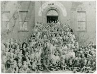
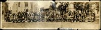
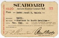
A report from the mayor, city council, and various governmental departments of Charleston, S.C. for the year 1920. The Year Book opens with an address from the mayor, John P. Grace, followed by reports from various departments.
Framed oil painting, "Shrimp Vendor," depicting an African American man with a tray of shrimp walking by a house with iron fence and balcony, typical of Charleston homes. On long term loan to the Avery Research Center from St. Mark’s Episcopal Church.
One of three scrapbooks compiled by William Henry Johnson containing, among other materials, photographs depicting scenes of the South Carolina Lowcountry, with descriptive notes. Volume 1 includes photographs depicting cemeteries, churches, plantations, historic buildings, ruins, landscapes, and the interiors of buildings. Subjects include locations in Berkeley County, St. Johns (Berkeley) Parish, Goose Creek, and along the Cooper River. Other sites and subjects include Belmont, Black Oak Church, Bluford, Casada, Cedar Grove, Cedar Spring, Comingtee, a Prioleau family burial ground, Crowfield, Dean Hall Plantation, Dockon Plantation, Eutaw, Eutaw Springs, Exeter, Fairspring, Fort Dorchester, Four Hole Swamp, Gippy, Gravel Hill, the gravestone of Susan Bee, Hanover Plantation, Indian Fields Campground, Ingleside, Indianfield, Liberty Hall Club, Lewisfield, Magnolia Cemetery, monument of Col. Hezekiah Maham, grave of Major Majoribanks, Medway Plantation, Mepkin, a milestone by the Cooper River, Moorfield, Mount Pleasant Plantation, Mulberry Castle, North Hampton, Numertia, The Oaks Plantation, Ophir, Otranto Hunting Club, Parnassus, Pimlico, Pinegrove, Pond Bluff, Pooshee Plantation, John Poppenheim's plantation, Quarter house, Red Bank Hunting Club, an Episcopal church in Pineville, Rice Hope Plantation, The Rocks, St. James Goose Creek church, St. Johns Berkeley rectory site, St. Johns AME Church, a St. Julien family house, a Santee Canal lock, "Sarrazin house," a shanty, Somerset Plantation, Somerton Plantation, "Francis Marion spring," Springfield, Stoney Landing, Strawberry Chapel, Ten Mile Hill, Thoroughgood, Wadboo Barony, Wadboo bridge, Walnut Grove, Walworth, Wampee, Wampoolah, Wappetaw, Washington Plantation, the Whaley place, White Hall, Wiskinboo, Woodlawn, and Yeamans Hall.
The College of Charleston Magazine is a monthly publication released by the College of Charleston's Chrestomathic Society during the academic year. This volume is comprised of the bound together publications from the months of November 1920-April 1921.
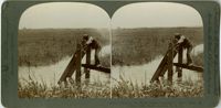
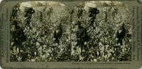
A stereoscopic image of an African American man using a rice trunk to tend rice. The bottom text of the picture states that the field is being flooded at high tide.
A notebook (ca. 1920) containing reminiscences by Rose P. Ravenel, who writes about her girlhood, her relationship with her "mammy" and her French nurse. She describes life at Farmfield Plantation during the Civil War, knitting socks for Confederate soldiers, making paper and envelopes, salt production, molasses candy, flower dolls, and the family's hardships after the Civil War.
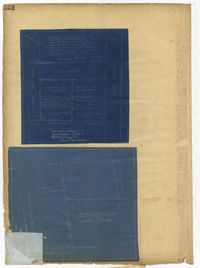
Page 246 of the City Engineer's Plat Book with one plat. The plat shows lots located between Rutledge Avenue and the Ashley River. Groups of lots are labelled with red letters. The plat also shows Darlington Avenue, Ashley Avenue, Piedmont Avenue, Hester Street, Clemson Street, Maple Street, Peachtree Street, Poplar Street, Pendleton Street, and Sans Souci Street.
Page 250 of the City Engineer's Plat Book with one plat. The plat shows lots between Romney Street and Williman Street, and east of Meeting Street. The plat also shows Isabella Street.
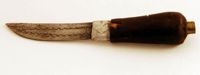
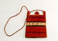
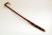
Knife contained in a leather sheath. There is a braided strap with a button loop closure and several decorative styles with a fringe at the base. Origin Liberia.
Page 252 of the City Engineer's Plat Book with two plats. Plat 1 shows lots on and near Lenwood Street, between South Bay Street and Boulevard Drive. Plat 2 shows lots located on and near the intersection of Huger Street and Rutledge Avenue.
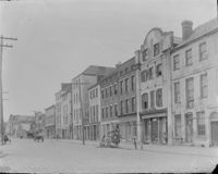
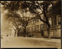
Photograph of Green Street (now Green Way) and north side of Randolph Hall in 1920. Construction of Randolph Hall, the most recognizable building at the College, began in 1828 under the direction of architect William Strickland. Flanking wings and portico for the main building were designed by Edward Brickell White and erected circa 1850. In 1886 the wings were destroyed by the Charleston earthquake and rebuilt between 1888 to 1894 under the direction of Gabriel Manigault.
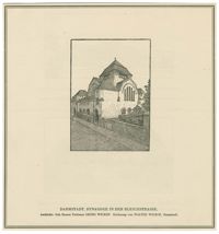
Black-and-white drawing of the exterior of the Orthodoxe Synagoge (Orthodox Synagogue) on the Bleichstraße in Darmstadt. Drawing by Walter Wickop. From Darmstadt und Umgebung in zweihundert Federzeichungen by August Buxbaum.
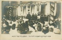
Black-and-white photographic postcard of Rabbi Ben-Zion Meir Hai Uziel addressing the first meeting of the Assembly of Representatives on October 7, 1920, in Jerusalem. On stage are Arthur Ruppin, Menaḥem Mendel Ussishkin, Yitzhak Ben-Zvi, David Yellin, Rabbi Jacob Meir, and Yosef Sprinzak.
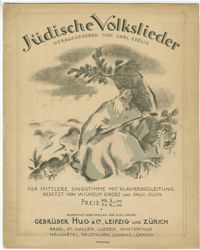
Sheet music cover for Jüdische Volkslieder : für mittlere Stimme mit Klavierbegleitung by Wilhelm Grosz and Paul Juon; edited by Carl Seelig, published Leipzig: Gebrüder Hug.
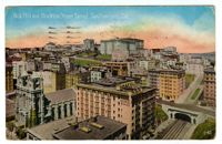
Color panoramic postcard of Nob Hill in San Francisco, including Temple Emanu-El on Sutter Street as it appeared after its restoration following the San Francisco earthquake and fire of 1906.


![[Neue Synagoge, Breslau]](https://iiif.library.cofc.edu/iiif/2/25172/full/200,/0/default.jpg)