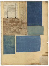
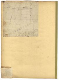
Page 125 of the City Engineer's Plat Book with seven plats. Plat 1 shows several measurements for a structure. Plat 2 shows the line of division between St. Mary's Church Yard and the "Property of Mrs. Anna D. Fleming." Plat 3 shows two wharves. Plat 4 shows lots and structures near wharf street. Plat 5 shows lots near the intersection of Washington Street and Laurens Street. Plat 6 shows lots between Rose Lane and Market Street, near where they intersect with East Bay Street. Plat 7 shows lots between Congress Street and Race Street, near Rutledge Street.
A report from the mayor, city council and various governmental departments of Charleston, South Carolina, for the year 1887. The Year Book opens with an address from Mayor Courtenay followed by reports from various departments and an appendix.
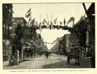
Caption: 'Charleston--Celebration of her recovery from the effects of the Earthquake.--from a photograph by Cook.--[see page 818.]' [full date November 12, 1887.]
Page 180 of the City Engineer's Plat Book with one plat. The plat shows lots located on and near Brigade Street, Lee Street, the City Boundary, and the "N.E.R.R. Right of Way."