Search
« Previous |
201 - 226 of 226
|
Next »
Search Results
Date:
1886
Description:
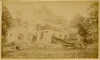
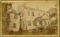
Caption: 'Cook's Earthquake Views of Charleston and Vicinity. Series No.2. No.141, Minott residence, Summerville.'
Date:
1886
Description:
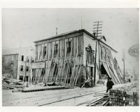
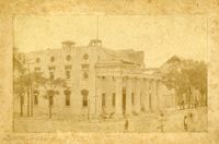
Charleston Earthquake scene. Possibly from Dr. E.P. Howland's series. Charleston Post Office (Exchange Building) shored up by timbers. [Copy]
Date:
1886
Description:
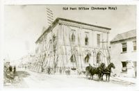
Charleston Earthquake scene. Possibly from Cook's Earthquake views, No.10, Post Office.' Typed on image at top: 'Old Post Office (Exchange Bldg).'
Date:
1886
Description:
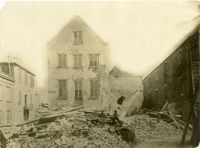
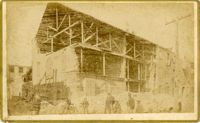
Charleston Earthquake scene. Possibly from Cook's Earthquake views, No.74, wreck in rear of Post Office, showing shell hole made during the war.'
Date:
1886
Description:
Charleston Earthquake scene. Written on reverse: 'Down town Guard house. South west corner [of] Meeting and Broad Sts., Charleston, S.C.'
Date:
1886
Description:
Charleston Earthquake scene. Caption typed at top of image: 'Main police station S.W. corner of Broad and Meeting Sts.'
Date:
1886
Description:
Caption: 'Cook's Earthquake Views of Charleston and Vicinity. Series No.2. No.191, Prioleau Street, 60 days after.'
Date:
1886
Description:
Caption: 'Cook's Earthquake Views of Charleston and Vicinity. Taken after the 31st of August, 1886. No.73, View on Prioleau Street.'
Date:
1886
Description:
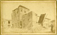
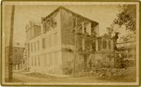
Charleston Earthquake scene. Written on front, at bottom: 'Charleston Earthquake Scene - ruins of cotton warehouse on Prioleau St.'
Date:
1886
Description:
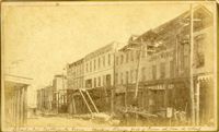
Caption: 'Cook's Earthquake Views of Charleston and Vicinity. Taken after the 31st of August, 1886. No.110, View on Queen Street.'
Date:
1886
Description:
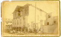
Caption: 'Cook's Earthquake Views of Charleston and Vicinity. Taken after the 31st of August, 1886. No.25, Vendue Range.' Written on front, at bottom: 'Charleston Earthquake scene - Vendue Range, foot of Queen St. near the wharf.' Sign for John Werner visible. Charleston city directory for 1886 shows business at 27 Vendue Range.
Date:
1886
Description:
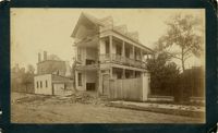
Caption: 'Cook's Earthquake Views of Charleston and Vicinity. Taken after the 31st of August, 1886. No.143, Voss residence, Summerville.'
Date:
1886
Description:
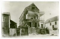
Caption: 'Cook's Earthquake Views of Charleston and Vicinity. Taken after the 31st of August, 1886. No.142, Shultz residence, Summerville.'
Date:
1886
Description:
Caption: 'Cook's Earthquake Views of Charleston and Vicinity. Taken after the 31st of August, 1886. No.69, ______ Sinkler, Tradd Street.'
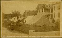
Date:
1886
Description:
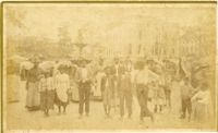
Caption: 'Cook's Earthquake Views of Charleston and Vicinity. Taken after the 31st of August, 1886. No.86, tents, Rutledge St[reet] Terrace.' Handwritten at bottom, front: 'Charleston Earthquake views - tents on Rutledge Terrace.'
Date:
1886
Description:
Caption: 'Cook's Earthquake Views of Charleston and Vicinity. Taken after the 31st of August, 1886. No.137, Smith Street, cor[ner] Montague [sic].'
Date:
1886
Description:
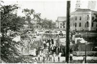
Charleston Earthquake scene. Tent village in Washington Square (also known as City Hall Park).
Date:
1886
Description:
Charleston Earthquake scene. Tent village in Washington Square (also known as City Hall Park).
Date:
1886
Description:
Caption: 'Cook's Earthquake Views of Charleston and Vicinity. Taken after the 31st of August, 1886. No.13, Washington Square.'
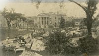
Date:
1886
Description:
Caption: 'Cook's Earthquake Views of Charleton and Vicinity. Taken after the 31st of August, 1886. No.101, camp on Wragg Square.'
Date:
1886
Description:
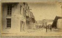
Caption: 'Cook's Earthquake Views of Charleston and Vicinity. Taken after the 31st of August, 1886. No.135, Corner State and Chalmers Streets.' Written on front, at bottom: 'Charleston Earthquake views - ruins cor[ner] Chalmers & State Str.'
Date:
1886
Description:
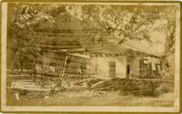
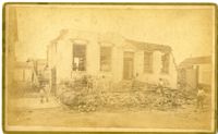
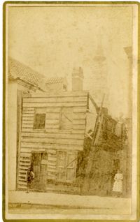
Caption: 'Cook's Earthquake Views of Charleston and Vicinity. Taken after the 31st of August, 1886. No.111, Ruined shanty, State Street.'
Date:
1886
Description:
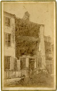
Caption: 'Cook's Earthquake Views of Charleston and Vicinity. Taken after the 31st of August, 1886. No.41, Corner of Tradd and Friend Streets.'
Date:
1886
Description:
Charleston Earthquake scene. Residence on Wilson Street.
Date:
1886
Description:
Caption: 'Cook's Earthquake Views of Charleston and Vicinity. Taken After the 31st of August, 1886. No.43, House in Water Street.'
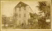
Date:
1886
Description:
Charleston Earthquake Scene. Possibly from Cook's Earthquake Views, No.56, Alderman Murray's residence, Wentworth Street.' Charleston city directory for 1886 shows Andrew B. Murray at 175 Wentworth.