Search
« Previous |
1 - 20 of 239
|
Next »
Search Results
Date:
1886
Description:
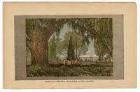
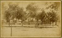
Illustration of Magnolia Cemetery overlooking water with a sailboat.
Date:
1886
Description:
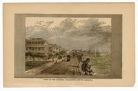
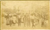
A color illustration of the Battery showing White Point Garden, the promenade, and African American children fishing.
Date:
1886
Description:
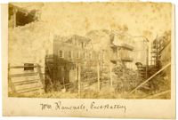
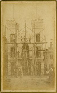
Charleston Earthquake scene. Possibly from Cook's Earthquake Views, no.63. William Ravenel, East Battery, rear. Written on front, at bottom: 'Wm Ravenel's, East Battery.'
Date:
1886
Description:
Caption: 'Cook's Earthquake Views of Charleston and Vicinity. Taken after the 31st of August, 1886. No.113, No.3 Meeting Street.'
Date:
1886
Description:
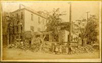
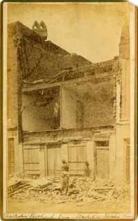
Caption: 'Cook's Earthquake Views of Charleston and Vicinity. Taken after the 31st of August, 1886. No.129, College as torn down.' Handwritten at bottom, front: 'Charleston Earthquake views - Charleston College. Both wings gone.'
Date:
1886
Description:
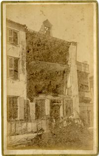
Caption: 'Cook's Earthquake Views of Charleston and Vicinity. Series No.2. No.106, Corner Meeting and Chalmers Streets.'
Date:
1886
Description:
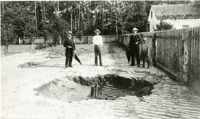
Charleston Earthquake scene. Possibly a copy of one of Cook's Earthquake Views. Three men and a boy standing near a fissure at Ten Mile Hill.
Date:
1886
Description:
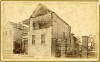
Caption: 'Cook's Earthquake Views of Charleston and Vicinity. Taken after the 31st of August, 1886. No.35, No.5 Engine House.'
Date:
1886
Description:
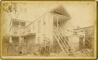
Caption: 'Cook's Earthquake Views of Charleston and Vicinity. Taken after the 31st of August, 1886. No.112, Rear of house on Smith's Lane.'
Date:
1886
Description:
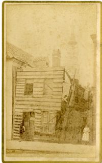
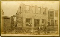
Caption: 'Cook's Earthquake Views of Charleston and Vicinity. Taken after the 31st of August, 1886. No.111, Ruined shanty, State Street.'
Date:
1886
Description:
Caption: 'Cook's Earthquake Views of Charleston and Vicinity. Taken after the 31st of August, 1886. No.110, View on Queen Street.'
Date:
1886
Description:
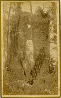
Caption: 'Cook's Earthquake Views of Charleston and Vicinity. Series No.2. No.166, Dorchester Church Tower, rear.'
Date:
1886
Description:
Caption: 'Cook's Earthquake Views of Charleston and Vicinity. Taken after the 31st of August, 1886. No.13, Washington Square.'
Date:
1886
Description:
Caption: 'Cook's Earthquake Views of Charleton and Vicinity. Taken after the 31st of August, 1886. No.101, camp on Wragg Square.'
Date:
1886
Description:
Caption: 'Cook's Earthquake Views of Charleston and Vicinity. Taken after the 31st of August, 1886. No.70, E.B. Hume, Legare Street.' Charleston city directory for 1886 shows Errington B. Hume at 17 Legare Street.
Date:
1886
Description:
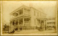
Caption: 'Cook's Earthquake Views of Charleston and Vicinity. Taken after the 31st of August, 1886. No.75, Cosgrove House, Market St.'
Date:
1886
Description:
Caption: 'Cook's Earthquake Views of Charleston and Vicinity. Series No.2. No.174, Hall residence, Limehouse Street.'
Date:
1886
Description:
Caption: 'Cook's Earthquake Views of Charleston and Vicinity. Taken after the 31st of August, 1886. No.72, Twisted chimney, Market Street.'
Date:
1886
Description:
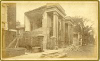
Caption: 'Cook's Earthquake Views of Charleston and Vicinity. Taken after the 31st of August, 1886. No.92, No.25 Legare Street.'
Date:
1886
Description:
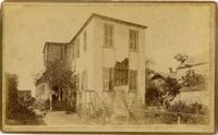
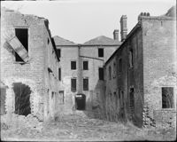
89 to 91 Church Street, Catfish Row (maybe after 1886 earthquake)