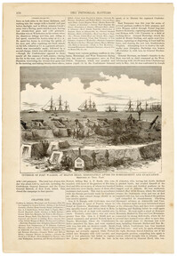
The illustration on the front page is captioned 'Interior of Fort Walker, at Hilton Head, immediately after its bombardment and evacuation'. The damage to the fort is in the foreground while in the background, sailing ships with small rowboats can be seen. On the verso are more illustrations. The top picture is captioned "Banks division crossing the Potomac previous to the Battle of Ball's Bluff." The left picture is captioned "Sinking of the peerless in a gale and rescue of the crew." The right illustration is captioned "Perilous position of a transport." The bottom picture is captioned "Capture of the steamer 'Fanny' by three Confederate steamers off Chicamicomica, N.C."
Letter to the members of St. Matthew's Lutheran Church- here abbreviated under its original name, the German Evangelical Lutheran Church- from the Building Committee, detailing repairs to the church after suffering hurricane ("cyclone") storm damage totaling $3,627, which in the committee's view should be raised by church members.
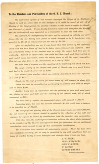
Main caption: 'South Carolina.--scenes in the track of the cyclone which devastated Charleston, August 25th. See page 43. 1. St. Michael's Church [upper left]. 2. Scene on the water front after the storm [top right]. 3. Destruction on South Battery [bottom].' [full date September 5, 1885.]
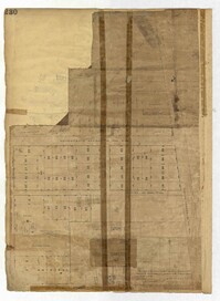
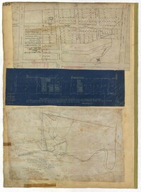
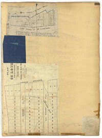
Page 230 of the City Engineer's Plat Book with one plat. The Plat features lots located between Chinquapin Street and President Street, and between Bee Street and Spring Street. It also shows several structures, Pine Street, and Chesnut Street. One lot is labelled "Vegetable Garden."
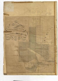
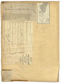
Page 234 of the City Engineer's Plat Book with one plat. The plat shows lots and structures located on Mill Street, President Street, Lucas Street, and Sixth Street. It also shows a lot labelled "U. S. Arsenal."
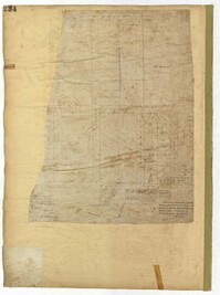
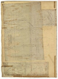
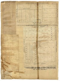
Page 231 of the City Engineer's Plat Book with one plat. The plat features lots belonging to "The Cannonsboro Whf & Mill Co." It shows Bee Street, Doughty Street, President Street, Lucas Street, and Mill Street.
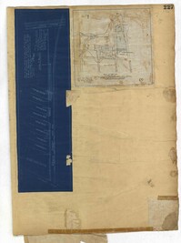
Page 227 of the City Engineer's Plat Book with two plats. Plat 1 shows lots and structures located on Grove Street, between King Street and Russell Street. Plat 2 features a "Plot of Ground Surrounding Charleston Colored Industrial School." Plat 2 also shows Fishburne Street, Mount Street, Congress Street, and President Street.
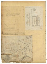
Page 212 of the City Engineer's Plat Book with three plats. Plat 1 shows lots located between Broad Street, Tradd Street, and Savage Street. Plat 2 shows lots and structures located near the intersection of Tradd Street and Chisolm Street, including wharves, a storehouse, a rice mill, an engine house, and a saw mill. Plat 3 shows lots, structures, and geographic features located between New Street and the Ashley River. Plat 3 also includes Tradd Street, Savage Street, Rutledge Street, Lynch Street, and a large stretch of marshland.
Page 198 of the City Engineer's Plat Book with three plats. Plat 1 shows land between President Street and Rutledge Street, and also shows Ashley Street, Boignard Street, Kennedy Street, Payne Street, Rosemont Street, and Krackes Street. Plat 2 shows lots along Mount Street, between Rutledge Street and Payne Street. Plat 3 shows land between "Town Creek" and Meeting Street, and also shows some marshland and a lot labelled "Roman Catholic Cemetery."
Page 182 of the City Engineer's Plat Book with three plats. Plat 1 shows lots and structures located along Spring Street, near its intersection and Chesnut Street. Plat 2 shows "the Schützenplatz," located at the end of Heriot Street. It also shows several structures, a marsh extending to the Ashley River, and a label reading "Known as the Village of Rikersville." Plat 3 shows lots and low land located near Meeting Street.
Page 165 of the City Engineer's Plat Book with three plats. Plat 1 shows lots located near a "Public Road from and to Charleston." It also shows marsh land, a fishpond, and a garden. Plat 2 shows land located near the intersection of America Street and Brigade Street. Plat 3 shows lots located near the intersection of Meeting Street and Riker Street, including a stretch of land labeled "Low Ground."
Page 164 of the City Engineer's Plat Book with three plats. Plat 1 shows lots located between Meeting Street and Aiken Street, and between Cooper Street and Line Street. Plat 2 shows lots located on Felix Street. Plat 3 shows lots located on Grove Street, and shows a stream and a label reading "Frenchman's Hill."
Page 160 of the City Engineer's Plat Book with four plats. Plat 1 shows a stretch of Mazyck Street, near its intersections with Queen Street and Short Street. Plat 2 shows lots and structures located on and near Reid Street, between Drake Street and Bay Street. Plat 4 shows lots and structures located between Nassau Street and Meeting Street, and between Stewart Street and Johnson Street.
Page 128 of the City Engineer's Plat Book with one plat. The plat shows a city block between Meeting Street and Church Street, and between Cumberland Street and Market Street. A label reads "Champion Cotton Press Co. Lots," and another reads "Tudor Ice House."
Page 100 of the City Engineer's Plat Book with four plats. Plat 1 features lots located near the intersection of Broad Street and Friend Street. Plat 2 shows lots and structures on Meeting Street. Plat 3 shows land located near the intersection of Drake Street and Cool Blow Street, including a stretch of the North Eastern Rail Road, a creek leading to the Cooper River, and some marshland. Plat 4 is affixed to the page so it folds in and out, and shows lots located near a stream, Pine Street, Alleyway Street, Norman Street, and Ashton Street.
Page 99 of the City Engineer's Plat Book with four plats. Plat 1 shows land located near Meeting Street, between Williams Street and Semmes Street. Plat 1 also shows Nassau Street, Romney Street, some marshland, and New Market Creek. Plat 2 shows a lot with two structures located on Laurel Street. Plat 3 features lots located between Congress Street and Gadsden Street, near Pinckney Street. Plat 4 features lots located along Mount Street, between President Street and Payne Street.
Page 97 of the City Engineer's Plat Book with three plats. Plat 1 shows a stretch of land extending from Cunnington Street to Columbus Street, with a projected rout for America Street. Plat 1 also shows Hampstead Mall, Meeting Street, several creeks, some city lands, and a stretch of King Street. Plat 2 shows land from near Line Street to Hudson Street, between King Street and Meeting Street. Plat 2 also features structures, including several freight depots. Plat 3 shows a lot labelled "Lands of Fourth Brigade," between Brigade Street and William Street.
Page 95 of the City Engineer's Plat Book with four plats. Plat 1 shows lots located between Mount Street and Congress Street, and between Rutledge Street and Payne Street. Plat 2 features lots near Meeting Street, and shows a stretch of low ground. Plat 3 shows lots located near Mount Street, Payne Street, and Lowndes Court. Plat 4 shows lots located on Fishburne Street.