The Kiawah Stock Account Book, 1877-1882, is kept by a member of the Vanderhorst Family for their estate Kiawah Plantation on Kiawah Island, South Carolina. Entries include information on the numbers of livestock sold, list of expenses and marketing and account statements for the overseer Quash Stevens.
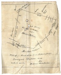
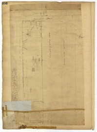
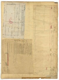
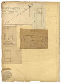
Plan of land in St. James Santee for Abraham Micheau. Names associated with this plat are Ann Colburn, Gardner, Anthony Germain, Buneli, B. Skipper, Isaac Skipper, Abraham Micheau, and William H. Simons.
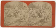
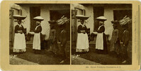
Stereoscopic image of African American cotton pickers in a cotton field on St. Helena Island, South Carolina. Handwritten caption on verso reads, "Cotton picking at the yard-St. Helena Island Fall of 1879."
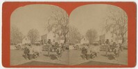
Stereoscopic image of five visible horse drawn carriages, some transporting cotton from the gin. Handwritten caption on the verso reads, "Some scene 1879-Cotten ginned and booked for shipping. Gin property of Mr. JJ Dale, J.R. Macdonald, George Wilkins."
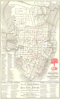
Map of the Charleston peninsula. Revised in 1879; published by Walker, Evans & Cogswell. Features locations of fire alarm boxes and public buildings, with indexes to each. Presented by A.R. Thomlinson, manufacturer of harness, saddles, bridles, etc., located at 137 Meeting Street. Measures 21.875" x 13.625"
A stereoscopic image of African American women holding baskets with wares on top of their heads and children carrying wares atop their head. The text at the bottom of the image identifies them as "street vendors."
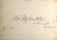
Pencil sketches and occasional watercolors by Charleston-born architect William Martin Aiken. Primarily landscapes and sketches of architectural elements in Boston, Mass.; Newport, R.I.; Brookline, Mass.; White Mountains, N.Y.; Chateaugay, N.Y.; and Quebec, Canada.
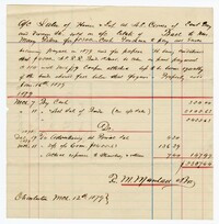
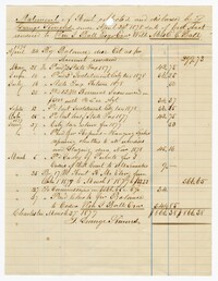
An account of sales of a house and lot on the corner of East Bay and Vernon Street in Charleston on account of the estate of the Ball family. Costs include those for advertising, commissions and the sale of bonds.
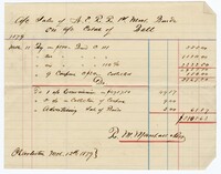
A statement on rents collected and distributed for the estate owned by Mrs. Eliza C. Ball with William Ball as her executor. The account also includes taxes and commissions.
Page 206 of the City Engineer's Plat Book with one plat. The plat shows lots and structures between Charlotte Street and Calhoun Street, near where they intersect with Washington Street. The plat also shows a planing mill, a saw mill, and a dock.
Page 185 of the City Engineer's Plat Book with four plats. Plat 1 shows lots and structures located near [Map too blurry to read, check when in-office]. Plat 2 shows lots and structures located near the intersection of Spring Street and Ashley Street. Plat 3 shows lots located near the intersection of Mount Street and Rutledge Avenue. Plat 4 shows lots located near Rutledge Avenue, between Congress Street and Huger Street.
Page 147 of the City Engineer's Plat Book with three plats. Plat 1 shows lots located between King Street and land owned by the South Carolina Railroad Company. Plat 2 shows lots and structures located between Charlotte Street and Calhoun Street, and between Washington Street and Meeting Street. It also shows Alexander Street, Elizabeth Street, and Henrietta Street. Plat 3 shows lots and structures located on and near the intersection of President Street and Cannon's Court.
Page 129 of the City Engineer's Plat Book with four plats. Plat 1 shows lots between Hayne Street and Market Street, near where they intersect with Meeting Street. Plat 2 features a lot and structures located along Meeting Street, between Hayne Street and Market Street. Plat 3 features a lot located on the "Charleston Harbour on Cooper River." Plat 3 also shows a wharf and other structures. Plat 4 shows the same area as Plat 3.
Page 131 of the City Engineer's Plat Book with three plats. Plat 1 shows lots and structures located on George Street. Plat 2 features a lot on Rutledge Street. Plat 3 shows lots located on King Street, near its intersection with Clifford Alley.
Page 106 of the City Engineer's Plat Book with ten plats. Plat 1 features a lot and its buildings located near the intersection of King Street and Tradd Street. Plat 2 features a lot and buildings located between Church Street and Water Street, near where the latter intersects with East Bay Street. Plat 3 shows lots located near the intersection of King Street and Grove Street. Plat 4 features a plat and building located on Church Street. Plat 5 features a lot located on the intersection of East Bay Street and Elliott Street. Plat 6 shows a lot located between two streets leading to wharves. Plat 7 shows lots, wharves, and docks located near the intersection of Market Street and East Bay Street. Plat 8 features a wharf and lot located near the intersection of Legare Street and South Bay Street. Plat 9 shows lots located on and near the intersection of Broad Street and East Bay Street. Plat 10 shows lots and some structures located on East Bay Street.
Page 112 of the City Engineer's Plat Book with five plats. Plat 1 shows lots and structures located on the north side of Tradd Street. Plat 2 shows lots located on the east side of Savage Street. Plat 3 shows lots located on King Street. Plat 4 shows lots located between Broad Street and Tradd Street, and between Lynch Street and the Ashley River. Plat 5 shows lots and structures located near the intersection of King Street and Broad Street.
Page 105 of the City Engineer's Plat Book with seven plats. Plat 1 shows several lots located on Chalmers Street. Plat 2 shows lots located near the intersection of East Bay Street and Market Street, and several structures, including docs and wharves. Plat 3 features lots and structures located on Chalmers Street. Plat 4 features a lot located on the intersection of Church Street and Waters Street, and shows several structures. Plat 5 shows a lot and several structures located on Waters Street. Plat 6 features a lot and buildings located on Broad Street. Plat 7 features the profiles of streets where tidal drains will be built. The profiles include Calhoun Street, Mazyck Street, Logan Street, Tradd Street, Coming Street, Chesnut Street, Spring Street, and Meeting Street.
1879, 1838, 1786, 1877, 1835, 1847, 1805, and 1807
Description:
Page 72 of the City Engineer's Plat Book with eight plats. Plat 1 is labelled as a "Plan of Mazyckborough" and shows land located near the intersections of Charlotte Street with Alexander Street and Washington Street. Plat 1 also shows marshlands, streams, and the Cooper River. Plat 2 features a lot and its structures located on Henrietta Street. Plat 3 shows lots located between Concord Street and the edge of the Cooper River Channel, and also shows Wharf Street. Plat 5 shows land and buildings located on Washington Street, and includes some marshland and a stream labelled "Creek to Cooper River." Plat 6 shows a "Plan of a Part of Wraggsborough" located between Elizabeth Street and the Cooper River Channel. The plat also labels some marshlands, part of a creek, Mazyckborough, the Village of Hampstead, "The Mall," Chapel Street, and Washington Street. Plat 7 shows a lot located near the intersection of King Street and Calhoun Street, and shows several structures including a kitchen. Plat 8 shows a plan for a market located on Boundary Street, near Water Street, Front Street, and Gadsden's Canal.
Page 64 of the City Engineer's Plat Book with six plats. Plat 1 features wharves near Concord Street and shows several other structures. Plat 2 shows "Dock Street or Queen Street" located towards the south, a structures and a creek near the center, and a lot labelled "Capt. Balls Lot" towards the north. Plat 2 also has a large label reading "Cooper River." Plat 3 shows lots located near Cumberland Street between Church Street and Philadelphia Street, and shows several structures on the lots. Plat 4 shows wharves and several buildings located between East Bay Street and the Cooper River. Plat 5 shows a stretch of land between King Street and a body of water, and also shows a stretch of Hasell Street. Plat 6 shows lots on Queen Street, and includes a lot labelled "St. Philips Church Yard." Plat 7 shows lots located near Queen Street, and has a label reading "St. Philips Church Yard."
Typed copy of a narrative concerning the harassment of the Gregorie family at Myrtle Grove plantation near Mt. Pleasant, SC, 1866. Gregorie details the destruction of personal property and crops, the wounding of his daughter and his battle for compensation for the damages inflicted upon his farm and family by African American troops after the war. 1879.
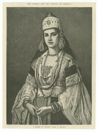
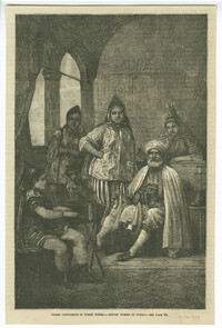
Black-and-white offset print reproduction of a Jewish woman from Tétouan. After a painting by Jean-François Portaels. Published in The Aldine, Volume 9.
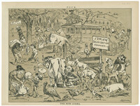
Caricature by Joseph Ferdinand Keppler published in the July 16, 1879, edition of Puck. The associated article reads in part : "The trouble with this country is that religion is getting to be altogether too much mixed up with affairs political and social; and the latest phase of this newest departure in American matters is the effort to populate the great waste places of the West with 'colonies' of certain religionists... Instead of little hamlets budding into thrifty villages, and blossoming into bustling cities, with the Methodist spire rising up into the same blue Heaven with the Catholic cross, while the dome of the Synagogue flashes between them--we are to have sectarian villages made up, as the case may be, exclusively either of Jews or Catholics..."
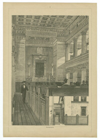
Black-and-white etching of the Hauptsynagoge (Main Synagogue) on Hans-Sachs-Platz in Nuremberg. Etching by Lorenz Ritter. From Malerische Ansichten aus Nürnberg.
Hand-colored wood engraving of a Jewish woman from Morocco. Wood engraving by Richard Henkel after Wilhelm Gentz. From Blätter für Kostümkunde, published Berlin: Franz Lipperheide.
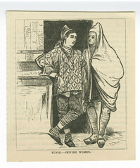
Black-and-white offset print reproduction of Jewish women from Tunis. From the article "Three continents in three weeks" by David Ker, published in the July 1879 edition of Frank Leslie's Popular Monthly.
A document conveying a tract of land to George Dispau. The document describes how W.D. Porter, a representative of the court, auctioned the land to the church so the estate of previous owner, Cephas Whittmore, could settle his debt.
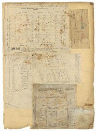
Page 33 of the City Engineer's Plat Book with five plats. Plat 1 shows land located near Mount Street's intersections with "Payne late Legare Street," Larne Court, and "Rutledge late Pinckney Street," including a stretch labelled "Flat Land." Plat 2 shows lots located near the intersection of Beaufain Street and King Street. Plat 3 shows lots located on "Council or New Street," near Gibbes Street, Smith Street, Beaufain Street, Tradd Street, New Street, and Savage Street. Plat 4 shows lots located along South Bay Street, between King Street and Meeting Street. Plat 5 shows lots, buildings, and structures located near the intersection of Line Street and Nassau Street.