Page 106 of the City Engineer's Plat Book with ten plats. Plat 1 features a lot and its buildings located near the intersection of King Street and Tradd Street. Plat 2 features a lot and buildings located between Church Street and Water Street, near where the latter intersects with East Bay Street. Plat 3 shows lots located near the intersection of King Street and Grove Street. Plat 4 features a plat and building located on Church Street. Plat 5 features a lot located on the intersection of East Bay Street and Elliott Street. Plat 6 shows a lot located between two streets leading to wharves. Plat 7 shows lots, wharves, and docks located near the intersection of Market Street and East Bay Street. Plat 8 features a wharf and lot located near the intersection of Legare Street and South Bay Street. Plat 9 shows lots located on and near the intersection of Broad Street and East Bay Street. Plat 10 shows lots and some structures located on East Bay Street.
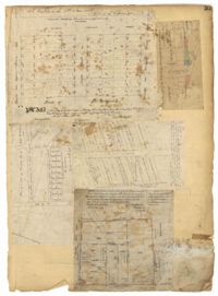
Page 33 of the City Engineer's Plat Book with five plats. Plat 1 shows land located near Mount Street's intersections with "Payne late Legare Street," Larne Court, and "Rutledge late Pinckney Street," including a stretch labelled "Flat Land." Plat 2 shows lots located near the intersection of Beaufain Street and King Street. Plat 3 shows lots located on "Council or New Street," near Gibbes Street, Smith Street, Beaufain Street, Tradd Street, New Street, and Savage Street. Plat 4 shows lots located along South Bay Street, between King Street and Meeting Street. Plat 5 shows lots, buildings, and structures located near the intersection of Line Street and Nassau Street.