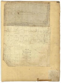
Page 167 of the City Engineer's Plat Book with two plats. Plat 1 shows lots located between Meeting Street and a line labelled "So. Ca. R. R." Plat 2 shows lots located between Moultrie Street and Line Street, and between America Street and Meeting Street. Plat 2 also shows lots between Hampton Street and Moultrie Street, West of Meeting Street.
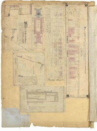
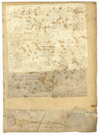
Page 92 of the City Engineer's Plat Book with six plats. Plat 1 features a "Plan of the Citadel Square," located between King Street and Meeting Street, and between Calhoun Street and Hudson Street. Plat 1 also shows several buildings, including the Citadel, the "U.S. Gov. Stables," and the "U.S. Hospital." Plat 2 shows lots and several buildings located between Smith Street and Franklin Street. Plat 3 shows lots and structures located along Market Street, between Church Street and Meeting Street. Plat 4 shows lots and structures located near Calhoun Street. Plat 5 shows several lots and structures located on King Street. Plat 6 is affixed to the page so it folds out, and shows lots located near Spring Street, between Chesnut Street and President Street. Plat 6 also shows Pine Street, Cannons Court, and Bee Street.
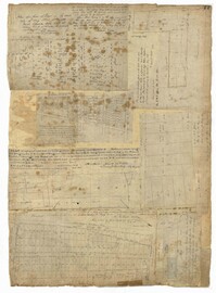
Page 77 of the City Engineer's Plat Book with seven plats, labelled 1 through 8 with Plat 3 missing. Plat 1 shows lots located between Smith Street and King Street, and between Morris Street and Radcliffe Street. Plat 1 also shows Coming Street and St. Philips Street, and a label reading "Bethlohim Congregation." Plat 2 shows lots and some structures near the intersection of King Street and Warren Street. Plat 4 shows lots between Smith Street and King Street, and north of Radcliffe Street. Plat 4 also shows Coming Street, St. Philips Street, Morris Street, and a lot labelled "Bethlehem Congregation." Plat 5 shows lots located near the intersection of Morris Street and St. Philips Street. Plat 6 shows lots located between Morris Street and "Hunter St now Line," and east of Coming Street. Plat 8 features a lot and structures located on the corner of St. Philips Street and Morris Street.
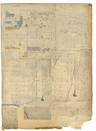
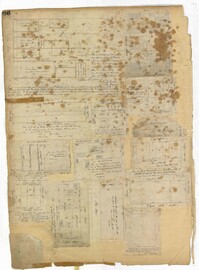
Page 83 of the City Engineer's Plat Book with eight plats. Plat 1 shows lots and some buildings located near Amherst Street, between Hanover Street and Nassau Street. Plat 2 shows lots located near the intersection of Mary Street and America Street, including a lot with structures including stables, a coach house, and a kitchen. Plat 3 shows lots located on Bay Street, near its intersections with North Street, Cooper Street, Drake Street, and Columbus Street. Plat 4 shows lots located along Drake Street, between Reid Street and Amherst Street. Plat 5 shows lots located on Meeting Street and Line Street. Plat 6 shows lots located near Line Street, between Meeting Street and Nassau Street. Plat 7 shows lots located near the intersection of Meeting Street and Columbus Street, and also shows a small Stretch of Spring Street. Plat 8 shows lots along Line Street, between Meeting Street and Aiken Street.
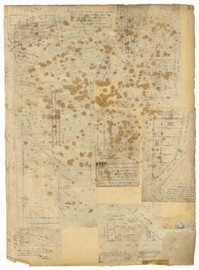
Page 66 of the City Engineer's Plat Book with fourteen plats. Plat 1 features buildings located near the intersection of King Street and Clifford Street. Plat 2 shows lots and structures located near the intersection of "Comings Street" and Wentworth Street. Plat 3 shows a lot and structures located on Pitt Street. Plat 4 shows lots located on a city block between Smith Street and Pitt Street, and between Montague Street and Wentworth Street. Plat 5 shows lots located on a city block between Montague Street and Wentworth Street, and between South Street and Rutledge Street. Plat 6 features a lot located near the intersection of "Comings Street" and Montague Street. Plat 7 shows lots and some structures located near the intersection of Bull Street and Coming Street. Plat 8 shows a lot and buildings located on Bull Street. Plat 9 Shows lots located near the intersection of Smith Street and Boundary Street. Plat 10 shows lots located on a city block between Lynch Street and Rutledge Street, and between Bull Street and Montague Street. Plat 11 shows lots and structures located near the intersection of Pitt Street and Bull Street. Plat 12 is features a lot located at the intersection of Pitt Street and Bull Street. Plat 13 Features lots located near the intersection of Bull Street and Lynch Street. Plat 14 shows lots located on Queen Street.
Page 51 of the City Engineer's Plat Book with seven plats. Plat 1 shows land located between Tradd Street and the Ashley River, and labels several features of geography such as a patch of marsh and some land labelled "Hard at low water." Plat 1 also shows a lot labelled "City Lands." Plat 2 shows lots and buildings located near the intersection of Tradd Street and Savage Street. Plat 3 shows land located on the west side of New Street. Plat 4 features a lot located at the intersection of New Street and Tradd Street. Plat 5 features lots located near the intersection of New Street and Tradd Street. Plat 6 shows lots located on and near Tradd Street. Plat 7 shows structures located near the intersection of New Street and Broad Street, including a building labelled "Theatre."
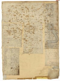
Page 41 of the City Engineer's Plat Book with six plats. Plat 1 shows land between Mount Street and Congress Street, and between a private street and "CITY LANDS Potter's Field." Plat 2 shows lots near Chestnut Street and near Spring Street, Ashton Street, Always Street, Lilly Street, and Pine Street. It also shows a few bodies of water. Plat 3 shows lots near Meeting Street's intersections with Market Alley, and State House Alley. It also labels a court house, the Treasury and Guard House, and St. Michael's Church. Plat 4 shows a stretch of land near President Street, Logan Street, Pinckney Street, Fishburne Street, Mount Street, Congress Street, and shows bodies of water and highlands. Plat 5 shows lots and buildings near the intersection Church Street and Water Street.
Page 47 of the City Engineer's Plat Book with four plats. Plat 1 shows lots between America Street and Meeting Street, and between Moultrie Street and Line Street. Plat 1 also includes a stretch of Moultrie Street and Hampton Street extending from Meeting Street to King Street. Plat 2 shows the plan of a wharf and channel located on East Bay Street, and includes several planned buildings and structures. Plat 3 shows lots of land located between East Bay Street and the "Edge of Channel of Cooper Street." Plat 4 shows lots located near East Bay Street's intersections with Water Street and Lynches Lane. Plat 4 shows several buildings, "Flat Broken ground," low lands, and a "Shoal dry at Low Water."
The Stoney Family Plantation Day Book, 1872 is a bound book kept by a member of the Stoney family recording payrolls, cash accounts and general accounts for laborers, formerly slaves and now freed persons, at Medway Plantation. The second half of the book is comprised of journal entries recording weather, work completed by laborers, conditions of the plantation crops, specifically rice, and visits from family and friends.
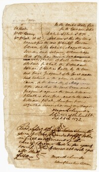
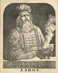
Black-and-white lithographed portrait of Aaron the high priest. With Hebrew text excerpted from Exodus 28:4 : "And they shall make holy garments for Aaron thy brother, and his sons, that he may minister unto Me in the priest's office." Entered according to the act of Congress in the year 1872 by Hyam Sakolski, in the office of the Librarian of Congress at Washington.
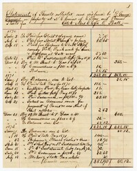
A set of annual reports of the the Fire Department from 1859-1872. Reports missing for years 1862-1865. The annual reports open with a statement from the Fire Chief and include multiple lists of department expenses, financial cost of fires, the cause of the fires, and locations of city property pertaining to the fire department.
Black-and-white offset print reproduction of the exterior of the Hurva Synagogue in Jerusalem. From Jerusalem : nach eigener Anschauung und den neuesten Forschungen geschildert by Philipp Wolff, published Leipzig: J.J. Weber.
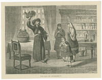
Black-and-white offset print reproduction depicting the ceremony of kapparot. From The home and synagogue of the modern Jew : sketches of modern Jewish life and ceremonies, published London: Religious Tract Society.
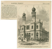
Black-and-white offset print reproduction of the exterior of Central Synagogue in New York. From a photograph by George Gardner Rockwood. Published in the July 6, 1872, edition of Harper's Weekly.
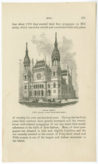
Black-and-white offset print reproduction of the exterior of the former location of Temple Emanu-El at 5th Avenue and 43rd Street in New York. From New York and its institutions, 1609-1871, by John Francis Richmond.
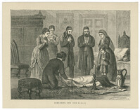
Black-and-white offset print reproduction of the preparation of a body for burial. From The home and synagogue of the modern Jew : sketches of modern Jewish life and ceremonies, published London: Religious Tract Society.
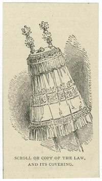
Black-and-white offset print reproduction of a Torah scroll with Torah mantle. From The home and synagogue of the modern Jew : sketches of modern Jewish life and ceremonies, published London: Religious Tract Society.
Black-and-white offset print reproduction depicting Yom Kippur in a synagogue in Paris. After a drawing by Auguste André Lançon. Published in the October 26, 172, edition of Le Monde illustré. Associated article published in the November2, 1872, edition of Le Monde illustré.