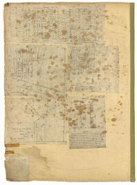
Page 48 of the City Engineer's Plat Book with five plats. Plat 1 shows lots located between Smith Street and King Street, and Radcliffe Street and Vanderhorst Street, including stretches of Thomas Street, Coming Street, St. Philip Street, and King Street. Plat 2 shows lots and buildings located near the intersection of King Street and South Bay Street. Plat 3 shows land near the intersection between Congress Street and Legare Street, and includes stretches of Hayne Street, Mount Street, and President Street. Plat 3 also shows some land labelled "City Land Potters Field." Plat 4 shows lots and a set of buildings located near Broad Street and Savage Street. Plat 5 shows lots and some buildings located on Gadsden Street.
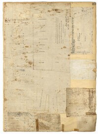
Page 27 of the City Engineer's Plat Book with five plats. Plat 1 shows lots located on Broad Street, between the intersections with East Bay Street and State Street. Plat 2 shows lots on Chapel Street. Plat 3 shows lots near Savage Street and Tradd Street. Plat 4 shows lots on Savage Street. Plat 5 shows lots near the intersection of Broad Street and East Bay Street.
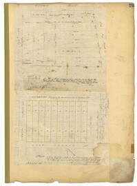
Page 25 of the City Engineer's Plat Book with two plats. Plat 1 shows lots and buildings near Guignard Street, located between East Bay Street and "Rapers Ally." Plat 2 shows lots located near Cumming Street, between Shepherd Street and Line Street.
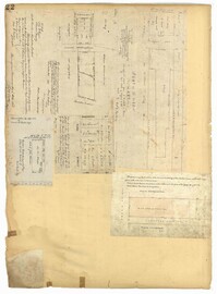
Page 22 of the City Engineer's Plat Book with five plats. Plat 1 shows lots located near the Charleston Harbor, Concord Street, Pinckney Street, and Pritchard Street. Plat 2 shows lots and structures located near the intersection of Concord Street and Pinckney Street, including a single-story building, a wharf, and a label reading "City property leased." Plat 3 shows a lot on Broad Street labelled "Lot of David McCredie." Plat 4 Shows lots located near Park Street, and between Shepherd Street and Line Street. Plat 5 shows lots near the intersection of Broad Street and Gadsden's Alley labelled with the names of banks.
Page 4 of the City Engineer's Plat Book with seven plats. Plat 1 features East Bay Street, Pinckney Street, Concord Street, and lots labelled "Burnt District." Plat 2 features lots on King Street. Plat 3 shows several lots on East Bay Street near the intersections with Pritchard Street and Hard Alley. Plat 4 shows three lots on East Bay Street. Plat 5 features lots at the intersection of East Bay Street and Hasell Street. Plat 5 shows a stretch of Queen Street including the intersections with Archdale Street and Friend Street, and includes a plat labelled "Catholic Church." Plat 7 shows plots of land on the intersection of Tradd Street and Meeting Street.
Volume Three in the Cote Bas and Mepkin Plantations Collection is a Southern Almanac for the Year of our Lord 1870 repurposed as a journal by Peter Gourdin. Entries include planting, farming and irrigation information from Cote Bas and Mepkin Plantations. Other entries concern rice, cotton, payments made for goods and services, social activities and clippings on various topics such as the Union Reform Party and voting for freedmen.
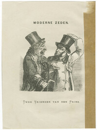
Hand-colored wood engraving of a hunchbacked Jewish man, Jaapje Blok, who hires himself out as a lectern at the Amsterdam Stock Exchange. Wood engraving by Henricus Adrianus (Henri) Bogaerts. Published in De katholieke illustratie : zondags-lektuur voor het katholieke Nederlandsche volk.
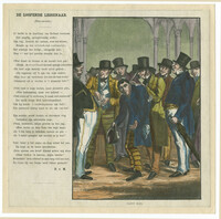
Black-and-white illustration of two men described as "Twee Vrienden van den Prins" ("two friends of the prince"). The accompanying story entitled "Modern Zeden" ("modern mores") describes two moneylenders, pictured here, and a prince who gives into their demands in order to receive money from them. Published in Asmodée: geillustreerde almanak.
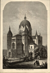
Color lithograph of the exterior of the Neue Synagoge (New Synagogue) in Hannover. Drawn and lithographed by Castell. Lithograph printed and published Hannover: Artist. Anstalt von Bühring, Pinther & Curtze.